

View Information About HSR Ratings
Note: After creating this page it came to our attention that the Historic American Engineering Record spelled the road as Beech when it should be Beach.

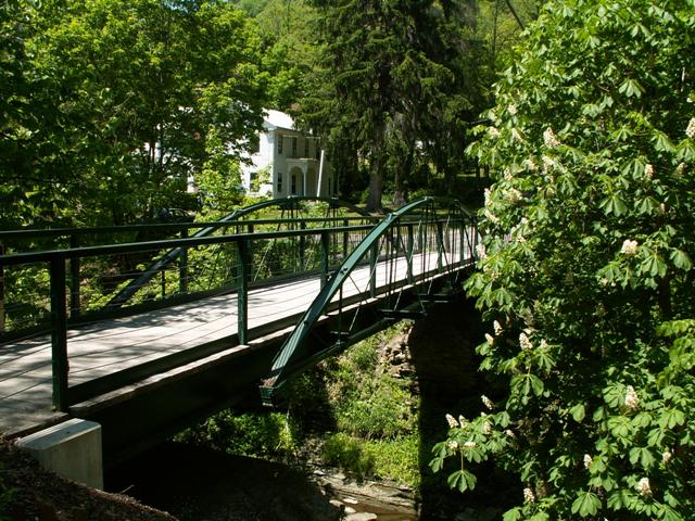
This bridge is an extremely rare example of a King Bridge Company bowstring truss bridge. With an 1873 construction date, it is also a very old example. Be sure to visit the HABS HAER page for technical drawings of this bridge, as well of photos showing the bridge prior to alteration.
It is certainly not the intention of this website to condemn well-intentioned preservation efforts. There are far too few examples of truss bridge preservation to go around not supporting the people whose efforts kept a bridge from ending up in the dumpster. However, with that said, a critical review of this bridge is presented below. The intention is not to make those who preserved this bridge feel bad, it is simply intended to influence future restoration projects, since what happened with this bridge was anything but the optimal solution. Restoration projects completed today should always focus on maintaining historic integrity. There are many resources available to any group wishing to restore a bridge correctly here in the 21st Century.
Upon approaching the Beech Road Bridge it appears that an abandoned truss bridge was restored for pedestrian use. However, this is not what happened. Instead, the historic truss bridge, including the abutments, were removed, and a new stringer bridge was built in its place on new abutments. The new abutments were designed differently, and the result was that this new bridge was considerably longer than the original bridge. The entire flooring system of the historic bridge was then scrapped, and the trusses were attached to the beams of this new bridge, which was four feet narrower, and considerably longer than the historic bridge originally was. The end result is an eight foot wide modern steel stringer bridge with two historic truss webs attached to it. The ends of the trusses hang in mid-air and do not rest on the abutments. Thus, when someone looks at the side of the bridge, it looks really quite silly.
The general objective with bridge preservation should always be to retain as much of the original material as possible, and if anything needs to be replaced, it should be replicated in a form that is in keeping with the original design. This was not done. A college student doing research on the various forms of flooring systems on historic bridges would be unable to use the Beech Road Bridge as a source anymore. In addition, the original dimensions of the bridge were not retained, and the structure was narrowed to eight feet, which gives the bridge an unusual "feel." Feel is important in preservation, since it is the intention to convey a period in history and make it as realistic as possible. Since the bridge looks unreasonably narrow, it is hard for visitors to imagine that this structure was originally built to handle such traffic as the horse and buggy. Worse, tall and modern-looking railings added to this bridge hide all that is left of the historic bridge, the truss webs.
Such drastic alterations are not necessary when restoring a bridge for pedestrian use. A properly restored bowstring truss is more than strong enough to support pedestrians. Narrowing the width is nothing more than a way to cut abutment costs, and it is doubtful how much costs it would actually cut.
Certainly, any solution, including what was done with the Beech Road Bridge is better than demolition and replacement. However it is doubtful that the Beech Road Bridge, a bridge on an abandoned road was actually facing a situation where preservation groups had to accept a drastically altered historic bridge or face demolition.
Note: The Historic Significance Rating determined for this bridge reflects the significance prior to alteration. Today, other examples better reflect the King Bridge Company design. The bridge today is worthy of a degradation to an 8 National and 7 Local rating.
![]()
![]()
Coordinates (Latitude, Longitude):
Search For Additional Bridge Listings:
Bridgehunter.com: View listed bridges within 0.5 miles (0.8 kilometers) of this bridge.
Bridgehunter.com: View listed bridges within 10 miles (16 kilometers) of this bridge.
Additional Maps:
Google Streetview (If Available)
GeoHack (Additional Links and Coordinates)
Apple Maps (Via DuckDuckGo Search)
Apple Maps (Apple devices only)
Android: Open Location In Your Map or GPS App
Flickr Gallery (Find Nearby Photos)
Wikimedia Commons (Find Nearby Photos)
Directions Via Sygic For Android
Directions Via Sygic For iOS and Android Dolphin Browser
USGS National Map (United States Only)
Historical USGS Topo Maps (United States Only)
Historic Aerials (United States Only)
CalTopo Maps (United States Only)

© Copyright 2003-2024, HistoricBridges.org. All Rights Reserved. Disclaimer: HistoricBridges.org is a volunteer group of private citizens. HistoricBridges.org is NOT a government agency, does not represent or work with any governmental agencies, nor is it in any way associated with any government agency or any non-profit organization. While we strive for accuracy in our factual content, HistoricBridges.org offers no guarantee of accuracy. Information is provided "as is" without warranty of any kind, either expressed or implied. Information could include technical inaccuracies or errors of omission. Opinions and commentary are the opinions of the respective HistoricBridges.org member who made them and do not necessarily represent the views of anyone else, including any outside photographers whose images may appear on the page in which the commentary appears. HistoricBridges.org does not bear any responsibility for any consequences resulting from the use of this or any other HistoricBridges.org information. Owners and users of bridges have the responsibility of correctly following all applicable laws, rules, and regulations, regardless of any HistoricBridges.org information.
![]()