

View Information About HSR Ratings
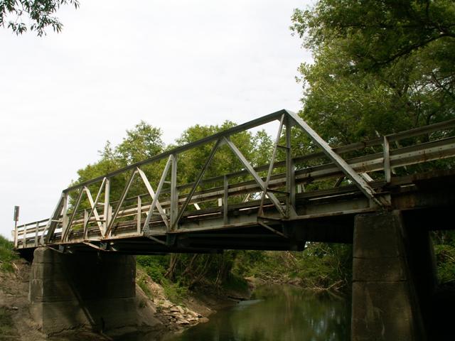
This bridge represents a type of bridge that was very common in Ontario and somewhat common Michigan and during the early twentieth century, but varies in how common it is elsewhere in North America. The design took a standard riveted Warren pony truss and riveted together just angles rather than the usual, more hefty assortment of built of beams composed of back-to-back channels and top chord made of built-up box beams. This bridge is a typical example of this angle-based design. The design was perhaps a little less strong, but it likely was more cost effective. Despite this, these bridges are generally still a reliable and strong bridge design. The continued use of this bridge by vehicular traffic was a good example. Alterations to the structure included some welded repairs to this bridge, and supplemental steel added to the floor beams. This bridge featured a stringer approach span at each end.
It should be noted that when this bridge was demolished, there was nothing significantly wrong with the trusses of this bridge. It likely could have been rehabilitated for less than the cost of replacement. It also had an extremely low Average Daily Traffic of only 27. Demolishing and replacing this bridge not only destroyed our nation's transportation heritage it was also an unnecessary waste of taxpayer dollars.
![]()
![]()
This historic bridge has been demolished. This map is shown for reference purposes only.
Coordinates (Latitude, Longitude):
Search For Additional Bridge Listings:
Bridgehunter.com: View listed bridges within 0.5 miles (0.8 kilometers) of this bridge.
Bridgehunter.com: View listed bridges within 10 miles (16 kilometers) of this bridge.
Additional Maps:
Google Streetview (If Available)
GeoHack (Additional Links and Coordinates)
Apple Maps (Via DuckDuckGo Search)
Apple Maps (Apple devices only)
Android: Open Location In Your Map or GPS App
Flickr Gallery (Find Nearby Photos)
Wikimedia Commons (Find Nearby Photos)
Directions Via Sygic For Android
Directions Via Sygic For iOS and Android Dolphin Browser
USGS National Map (United States Only)
Historical USGS Topo Maps (United States Only)
Historic Aerials (United States Only)
CalTopo Maps (United States Only)

© Copyright 2003-2024, HistoricBridges.org. All Rights Reserved. Disclaimer: HistoricBridges.org is a volunteer group of private citizens. HistoricBridges.org is NOT a government agency, does not represent or work with any governmental agencies, nor is it in any way associated with any government agency or any non-profit organization. While we strive for accuracy in our factual content, HistoricBridges.org offers no guarantee of accuracy. Information is provided "as is" without warranty of any kind, either expressed or implied. Information could include technical inaccuracies or errors of omission. Opinions and commentary are the opinions of the respective HistoricBridges.org member who made them and do not necessarily represent the views of anyone else, including any outside photographers whose images may appear on the page in which the commentary appears. HistoricBridges.org does not bear any responsibility for any consequences resulting from the use of this or any other HistoricBridges.org information. Owners and users of bridges have the responsibility of correctly following all applicable laws, rules, and regulations, regardless of any HistoricBridges.org information.
![]()