

View Information About HSR Ratings

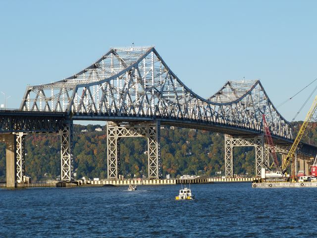
This impressive bridge is the longest bridge in New York State with a length of just over three miles. While not the an early example of this bridge type, the bridge is significant for its size. The bridge has three cantilever through truss main spans, and a very long series of simple Warren deck truss approach spans leading up to these main spans. The approach spans follow a curved layout giving the bridge a unique layout. The cantilever through truss spans are both unusual and technologically significant. The 1212 foot center span is one of the longest cantilever truss spans in the country. It includes a suspended span. The design of the cantilever truss is unusual and visually pleasing, particularly on account of the top chord on the center span. Like most cantilever truss bridges, the top chord slopes down along the cantilever arms as it becomes more distant from the piers, however this pattern usually ends at the suspended span, where the top chord is unusually horizontal. Instead, on this bridge, the suspended span's top chord is polygonal and takes a sagging shape that matches that of the cantilever arms. This gives the center span a consistent curved appearance that gives the bridge an element of grace not usually found on cantilever truss bridges. This is also a very wide bridge among cantilever and continuous through trusses, with a roadway that supports six lanes.
Despite the historic and technological significance of this bridge, it is being replaced, and although the new bridge is being built next to it, this historic bridge will be demolished after the replacement is complete. This is a shame. Imagine if this bridge, currently capable of carrying heavy Interstate traffic, were left standing next to its replacement bridge for pedestrian use. With its wide width, a unique linear park could be created on the bridge. The bridge could likely support the light load of pedestrians for decades even without repairs. However, imaginative solutions like this are not seriously considered. Perhaps some would argue that such a preservation solution would cost money. The irony of this however is that the cost would not be much especially when you consider how much the United States spends overseas on other counties. Is it so much to ask that this country spend a little extra money on itself, on a preservation solution that would create a fun and unique destination for area residents and visitors? This bridge crosses in a very scenic area, and a unique preserved pedestrian bridge would be a nice attraction for the area.
This bridge was built during a steel shortage during the Korean War. Reportedly, as a result it was not built as heavily as it might have been and some sources claim it was only ever designed to last 50 years as a result. The bridge's cantilever trusses do have a somewhat lightweight look to them when you consider the immense span length and unusually wide roadway, both things that require more massive trusses.
Pedestrians are not allowed on the bridge, but HistoricBridges.org is happy to offer a beautiful sequence of still photos taken with a GoPro camera in the photo gallery. These wide angle photos provide both a look at the details of the cantilever truss from on the bridge. Additionally, GoPro video is available which captures the experience of driving over the bridge.
Information and Findings From Pennsylvania's Historic Bridge InventoryDiscussion of Bridge The Tappan Zee Bridge was constructed between 1952 and 1955. Captain Emil H. Praeger, U.S. Navy Retired (1882-1973), served as chief engineer for Madigan-Hyland, the designers of the bridge. The bridge is 3.1-mile-long structure supported by a substructure consisting of abutments and 198 piers. It is the longest bridge in the state and one of the longest in the country. It also has the world's ninth longest cantilever span, at 1,212 feet. It has been determined eligible for National Register listing for its significance in the areas of transportation and engineering. The Tappan Zee Bridge is not designated as a National Historic Landmark. The Tappan Zee Bridge (NR-eligible) was determined eligible for the NR in 2003 under Criteria A and C. The bridge carries the New York State Thruway over the Hudson River from Rockland to Westchester County. Rockland County officials began to advocate for the construction of a bridge across the river to Westchester County near the present-day location of the Tappan Zee Bridge during the early 20th century. Studies were undertaken at that time which indicated the depth of bedrock under the river bed was too great to permit bridge construction. However, the concept for a Hudson River crossing between the counties was explored again roughly 15 years later due to the creation of NYSTA in 1950 and the Federal Interstate Highway System in 1954, which illustrated a pressing need for a Hudson River crossing between the two counties. In response to this need, the Tappan Zee Bridge was constructed between 1952 and 1955. Captain Emil H. Praeger, U.S. Navy Retired (1882-1973), served as chief engineer for Madigan-Hyland, designers of the bridge. To solve the depth to bedrock problem identified in the 1930s, Praeger- who also designed Shea and Dodger Stadiums, the Nebraska State Capitol, and the world's largest telescope in Arecibo, Puerto Rico- developed an innovative system in which eight buoyant caissons were constructed north of the crossing site in a natural clay pit in Grassy Point, the world's largest natural dry dock. Upon their completion, the clay pit was flooded and the caissons were floated downriver into place. The completed bridge is a 3.2-mile-long structure supported by a substructure consisting of abutments and 197 piers. The piers are erected upon four types of foundations, including river-based timber piles and the eight buoyant caissons. Piers in the river are protected by upstream and downstream ice breakers, and the caissons are also protected by a fender system. In the mid-1980s, notable deterioration of the Tappan Zee Bridge was recorded, after which an extensive repair program was commenced. Targeted repairs were undertaken through the mid-1990s, including repairs to the concrete deck, steelwork, bearings, columns, and piles. Due to the high rate of deterioration, major rehabilitation of the deck bearings, barriers, steelwork, and concrete were again initiated in September 2007. The Tappan Zee Bridge is the longest bridge in the state and one of the longest in the country. It also has the world's ninth longest cantilever span, at 1,212 feet. It has been determined eligible for NR listing under Criterion A for its significance in the area of transportation and Criterion C for its significance in the area of engineering. Character-defining features identified in the 2003 SHPO resource evaluation include the bridge's unique caisson support system, the length of its cantilever span, and the total bridge length. Information From American Bridge Company American Bridge was prime superstructure contractor for the 7,300' (2,225m) deep-water portion of this 16,000' (4,900m) crossing of the Hudson River above New York City. The three-span channel unit is a 2,415' (736m) cantilevered truss that was constructed by erecting the anchor (flanking) spans on falsework trusses and cantilevering the 1,212' (370m) mainspan from both directions. The 20 deck truss approach spans were constructed at an on-land yard facility and floated into place. Each span was about 250' long by 64' wide by 26' deep (76m by 20m by 8m), and weighed 830 tons (753mt). Bridge History From Wikipedia (CC-BY-SA 3.0) With the increasing demands for commuter travel taxing the existing bridges and tunnels, the Port Authority of New York and New Jersey had plans in 1950 to construct a bridge across the Hudson near Dobbs Ferry,
New York. The proposal was overridden by New York State Governor Thomas E. Dewey, who wanted to construct a bridge to connect the New York State Thruway across Westchester to the New England Thruway. The Port Authority promised its
bondholders that it would not allow any other entity to construct a river crossing within its jurisdiction, which reached to a point one mile (1.6 km) south of Nyack on the western shore of the Hudson River and across to
Tarrytown[8] on the eastern shore. |
![]()
![]()
![]()

![]()
This historic bridge has been demolished. This map is shown for reference purposes only.
Coordinates (Latitude, Longitude):
Search For Additional Bridge Listings:
Bridgehunter.com: View listed bridges within 0.5 miles (0.8 kilometers) of this bridge.
Bridgehunter.com: View listed bridges within 10 miles (16 kilometers) of this bridge.
Additional Maps:
Google Streetview (If Available)
GeoHack (Additional Links and Coordinates)
Apple Maps (Via DuckDuckGo Search)
Apple Maps (Apple devices only)
Android: Open Location In Your Map or GPS App
Flickr Gallery (Find Nearby Photos)
Wikimedia Commons (Find Nearby Photos)
Directions Via Sygic For Android
Directions Via Sygic For iOS and Android Dolphin Browser
USGS National Map (United States Only)
Historical USGS Topo Maps (United States Only)
Historic Aerials (United States Only)
CalTopo Maps (United States Only)

© Copyright 2003-2024, HistoricBridges.org. All Rights Reserved. Disclaimer: HistoricBridges.org is a volunteer group of private citizens. HistoricBridges.org is NOT a government agency, does not represent or work with any governmental agencies, nor is it in any way associated with any government agency or any non-profit organization. While we strive for accuracy in our factual content, HistoricBridges.org offers no guarantee of accuracy. Information is provided "as is" without warranty of any kind, either expressed or implied. Information could include technical inaccuracies or errors of omission. Opinions and commentary are the opinions of the respective HistoricBridges.org member who made them and do not necessarily represent the views of anyone else, including any outside photographers whose images may appear on the page in which the commentary appears. HistoricBridges.org does not bear any responsibility for any consequences resulting from the use of this or any other HistoricBridges.org information. Owners and users of bridges have the responsibility of correctly following all applicable laws, rules, and regulations, regardless of any HistoricBridges.org information.
![]()