

View Information About HSR Ratings

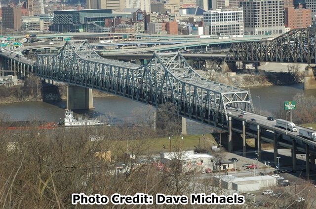
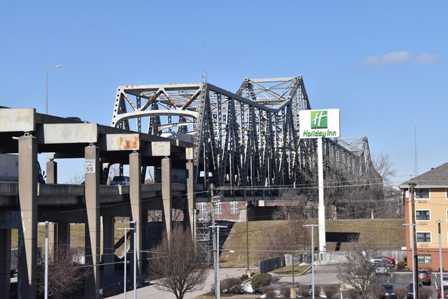
This is a large cantilever truss bridge that features two deck levels for traffic. It is a rare example of a double-deck bridge and one of the rapidly declining number of bridges remaining over the Ohio River that are 50 years old or older. It also is an increasingly rare example of a cantilever truss bridge, a beautiful, complex bridge type that has sadly been the victim of widespread nationwide demolition despite the fact that these bridges can be economically rehabilitated to safely continue to carry traffic. While the Brent Spence Bridge is a relatively late example of a cantilever truss bridge with a 1963 construction date, the bridge is still historically significant in light of the aforementioned facts.
The Brent Spence Bridge celebrates its 50th birthday in 2013, and this is significant because this bridge has previously been considered ineligible for listing in the National Register of Historic Places. With rare exceptions, only structures 50 years old and older are considered for the National Register. Now that the bridge meets that 50 year threshold, HistoricBridges.org believes this bridge should be reevaluated and considered eligible under Criterion C (engineering significance) as an increasingly rare example of a large cantilever truss bridge, particularly unusual for its double deck configuration. The trusses of this bridge appear to retain good historic integrity with no substantial alteration to original materials, design, or appearance. The bridge was also designed by the important engineering firm Modjeski and Masters. Renowned bridge engineer Ralph Modjeski was no longer alive when the Brent Spence Bridge was designed, but his company that lived on after his death continued to demonstrate a proficiency in designing large span bridges with the construction of the Brent Spence Bridge. Modjeski and Masters remains in business today, and in addition to work with new bridge construction, they have become experts in helping to rehabilitate and keep in service bridges that they designed years ago.
The future of this bridge has for many years been uncertain. The bridge has carried a tremendous amount of traffic, no less than two interstate freeways, far more than the bridge was designed to carry. The narrow lanes crammed with all this traffic put both drivers and the structural health of the bridge at risk. For a time, this bridge was at risk for demolition and replacement. However as of 2013, an extensive project study has moved toward a much better solution, which is to build a new bridge while also rehabilitating the Brent Spence Bridge. This, combined with some rerouting of the freeways to take advantage of this new two bridge configuration will spread traffic out, allow the Brent Spence Bridge to carry a more appropriate volume of traffic and with wider, safer traffic lanes. This is a win-win solution. Two bridges provides some redundancy in case one bridge ever has to be closed due to an accident or for repair work. The two bridge solution also preserves the historic Brent Spence Bridge.

The Brent Spence Bridge, despite its relatively late 1963 construction date, still offers some details associated with older historic bridges and no longer used in modern bridge construction. This includes the use of rivets in built-up beams, and built-up beams with lattice in the the bracing. The use of eyebar chains and pin connections around the top of the two towers on the top chord is unusual, and the eyebars and pins seem are a nod to earlier bridge technologies that were rarely used by 1963. The bridge has an attractive arched portal and sway bracing design which adds some class to the bridge. Evidence of its later construction and a transition away from historical methods like riveting is evidenced in the bolted connections on this bridge.
The Brent Spence Bridge proper is listed in inventories as just the cantilever spans, and as such the technical facts table presented on this page refers to just those spans. However it should be noted that a long series of steel stringer spans provide an approach to the bridge. These spans are noteworthy because not only do they bring the roadway up to the level of the bridge decks, it must transition the roadway from a divided highway to a double-deck configuration, which requires some creative engineering.
This bridge is tagged with the following special condition(s): Unorganized Photos
![]()
![]()
![]()
![]()
![]()
Coordinates (Latitude, Longitude):
Search For Additional Bridge Listings:
Bridgehunter.com: View listed bridges within 0.5 miles (0.8 kilometers) of this bridge.
Bridgehunter.com: View listed bridges within 10 miles (16 kilometers) of this bridge.
Additional Maps:
Google Streetview (If Available)
GeoHack (Additional Links and Coordinates)
Apple Maps (Via DuckDuckGo Search)
Apple Maps (Apple devices only)
Android: Open Location In Your Map or GPS App
Flickr Gallery (Find Nearby Photos)
Wikimedia Commons (Find Nearby Photos)
Directions Via Sygic For Android
Directions Via Sygic For iOS and Android Dolphin Browser
USGS National Map (United States Only)
Historical USGS Topo Maps (United States Only)
Historic Aerials (United States Only)
CalTopo Maps (United States Only)

© Copyright 2003-2024, HistoricBridges.org. All Rights Reserved. Disclaimer: HistoricBridges.org is a volunteer group of private citizens. HistoricBridges.org is NOT a government agency, does not represent or work with any governmental agencies, nor is it in any way associated with any government agency or any non-profit organization. While we strive for accuracy in our factual content, HistoricBridges.org offers no guarantee of accuracy. Information is provided "as is" without warranty of any kind, either expressed or implied. Information could include technical inaccuracies or errors of omission. Opinions and commentary are the opinions of the respective HistoricBridges.org member who made them and do not necessarily represent the views of anyone else, including any outside photographers whose images may appear on the page in which the commentary appears. HistoricBridges.org does not bear any responsibility for any consequences resulting from the use of this or any other HistoricBridges.org information. Owners and users of bridges have the responsibility of correctly following all applicable laws, rules, and regulations, regardless of any HistoricBridges.org information.
![]()