View Information About HSR Ratings
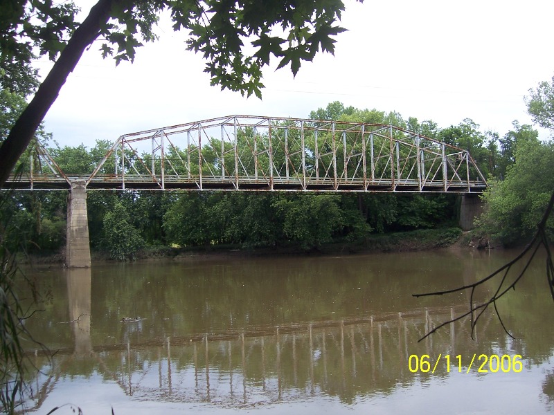
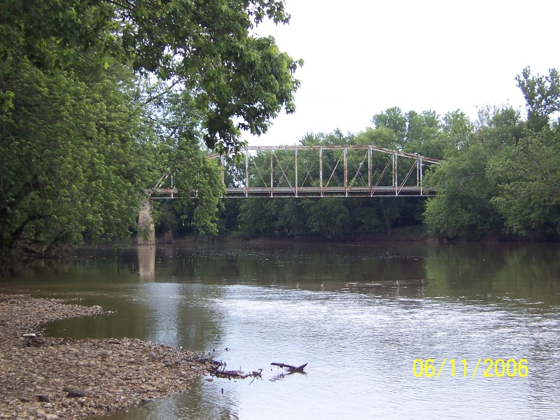
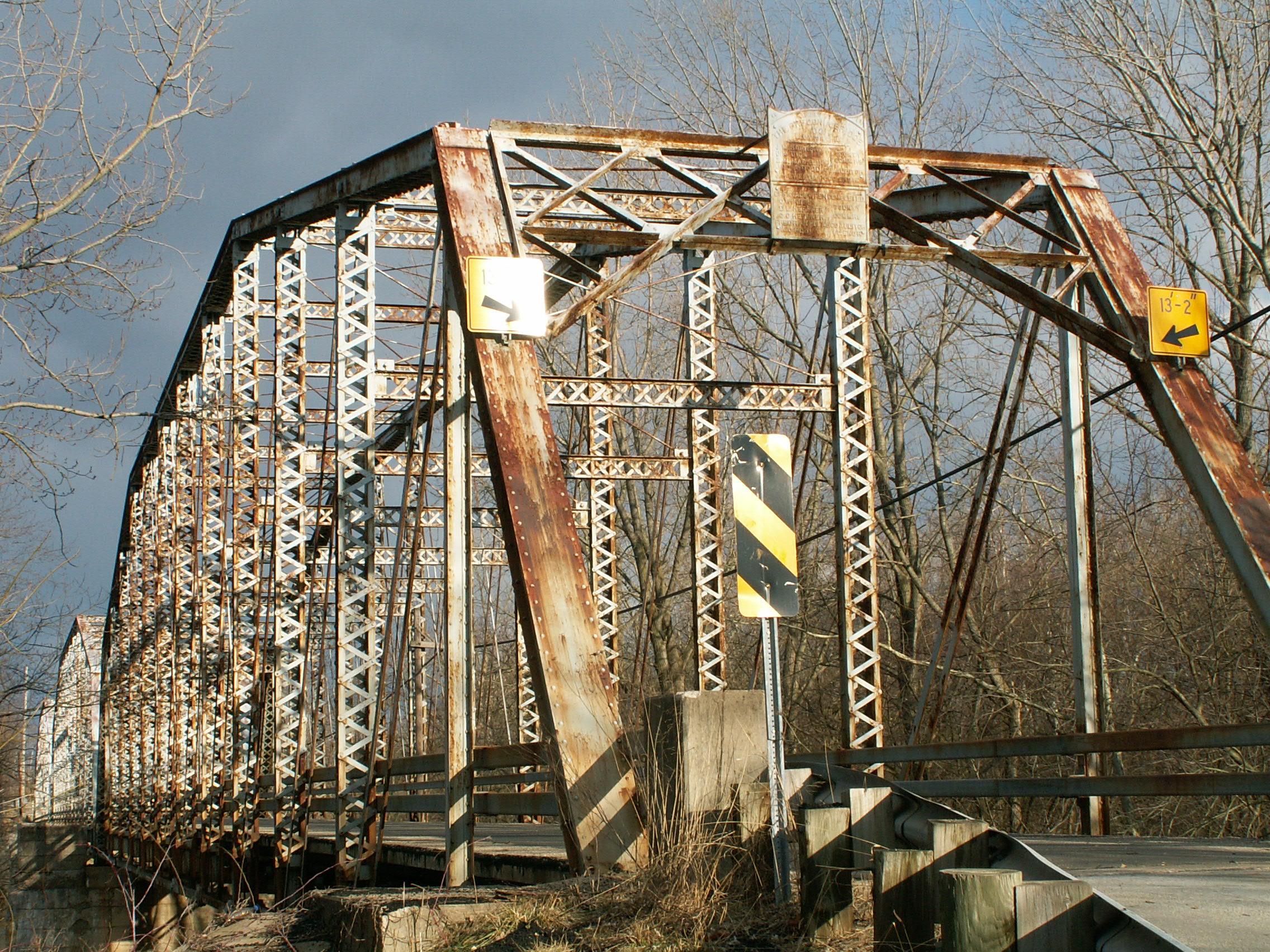
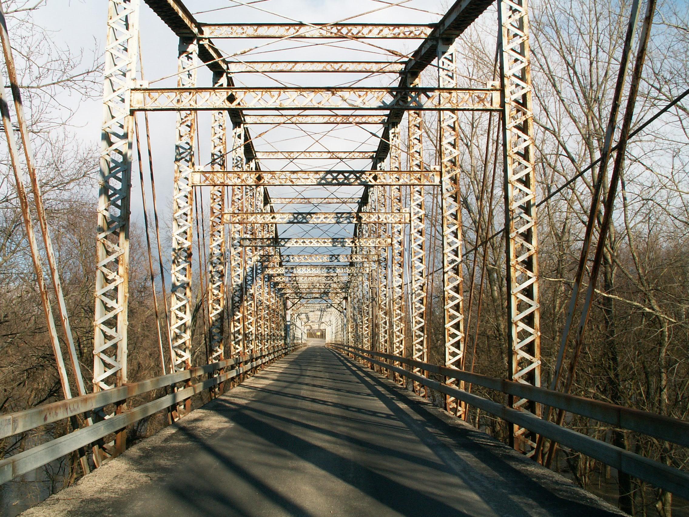
This bridge is one of the most impressive examples of pin-connected construction in the state of Ohio, due to its long, multi-span configurations. Even just one of this bridge's three spans is an impressive structure in its own right, with each span around 236 feet in length and composed of thirteen panels. This bridge is a relatively late example of pin-connected technology, with a 1913 construction date, however is historically significant for its long, multi-span configuration and impressive Camelback truss configuration. The bridge features a lattice portal bracing. Lattice is also present on the underside of the top chord and end posts. There is v-lacing on the verticals and the sway bracing. This, along with its length combine to make an attractive structure that offers a magnificent "tunnel effect" when crossed. The bridge also retains its builder plaques. The bridge features unusual concrete abutments that have lines carved in them to give them the appearance of stone blocks.
This bridge however was demolished and replaced by Pickaway County in 2008. This is a poor course of action, since as evidenced by a school bus crossing the structure, it is in relatively good condition and could be restored. With an alternate non-restricted crossing two miles south of this bridge, trucks have only a short detour, a small price to pay to keep this invaluable structure around for future generations to enjoy. As a long structure, this is a bridge that is not only visually impressive, it is historically significant as well. Commercial Point Road is not an essential through route, and is simply a shortcut for locals trying to get around, a purpose that the truss bridge could continue to serve if restored. If sight distance is a concern for this long bridge, a stoplight could be installed to direct traffic automatically.
The demolition of this structure marks the loss of a beautiful and significant part of Ohio's rich transportation heritage. It also will mark yet another example of how the weak laws in the United States designed to protect historic bridge lack teeth and do not effectively protect historic bridges. Not only is this a very important bridge, it is not even in all that bad of shape, compared to many truss bridges. It is a bridge that deserves to be rehabilitated.
Information and Findings From Ohio's Historic Bridge InventorySetting/Context The bridge carries a 2 lane road over a stream in a rural area of active farms. At the west end of the bridge are woods and fields. At the east end of the bridge are a hazardous waste site and scattered 20th-century residences. Physical Description The 3 span, 710'-long, pin-connected Camelback thru truss bridge is traditionally composed of built-up compression members and eyebar tension members. It is supported on concrete abutments and piers. Integrity Rehabilitated, 1984. Floorbeams strengthened with coverplate. Deck replaced. Summary of Significance The 1914 Camelback thru truss bridge built by the Oregonia Bridge Co. is a complete and long-span example of its type/design. The 1983-84 rehabilitation project did not result in an adverse effect. The eligible recommendation
of the prior inventory remains appropriate. Justification The pin connected thru truss bridge is one of 13 extant examples of bridges with polygonal upper chords and/or subdivided panels in the state that date from 1888 until 1923. It is of moderate significance given that the numbers in the population. Bridge Considered Historic By Survey: Yes View PDF Historic Bridge Inventory Sheet
|
![]()
![]()
![]()

![]()
This historic bridge has been demolished. This map is shown for reference purposes only.
Coordinates (Latitude, Longitude):
Search For Additional Bridge Listings:
Bridgehunter.com: View listed bridges within 0.5 miles (0.8 kilometers) of this bridge.
Bridgehunter.com: View listed bridges within 10 miles (16 kilometers) of this bridge.
Additional Maps:
Google Streetview (If Available)
GeoHack (Additional Links and Coordinates)
Apple Maps (Via DuckDuckGo Search)
Apple Maps (Apple devices only)
Android: Open Location In Your Map or GPS App
Flickr Gallery (Find Nearby Photos)
Wikimedia Commons (Find Nearby Photos)
Directions Via Sygic For Android
Directions Via Sygic For iOS and Android Dolphin Browser
USGS National Map (United States Only)
Historical USGS Topo Maps (United States Only)
Historic Aerials (United States Only)
CalTopo Maps (United States Only)

© Copyright 2003-2024, HistoricBridges.org. All Rights Reserved. Disclaimer: HistoricBridges.org is a volunteer group of private citizens. HistoricBridges.org is NOT a government agency, does not represent or work with any governmental agencies, nor is it in any way associated with any government agency or any non-profit organization. While we strive for accuracy in our factual content, HistoricBridges.org offers no guarantee of accuracy. Information is provided "as is" without warranty of any kind, either expressed or implied. Information could include technical inaccuracies or errors of omission. Opinions and commentary are the opinions of the respective HistoricBridges.org member who made them and do not necessarily represent the views of anyone else, including any outside photographers whose images may appear on the page in which the commentary appears. HistoricBridges.org does not bear any responsibility for any consequences resulting from the use of this or any other HistoricBridges.org information. Owners and users of bridges have the responsibility of correctly following all applicable laws, rules, and regulations, regardless of any HistoricBridges.org information.
![]()