

View Information About HSR Ratings
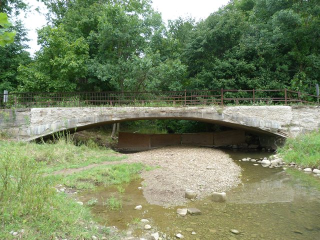
This small and unassuming bridge is one of the oldest concrete bridges in the country. With a Melan-style reinforcing system, it is also one of the rarest types of concrete arch bridge. The Melan system does not use rebar (reinforcing rods) to strengthen the concrete, but instead uses a steel arch embedded in concrete. In this case, the steel arch is created by use of bent railroad rails. The bridge retains original railings on one side only. The original railings are an unusual riveted metal fence style railing.
The bridge is a nationally significant historic bridge, yet is in a severely deteriorated condition. While bad for the bridge, the deterioration has exposed a section of the Melan style reinforcing, enabling photography of this normally hidden detail. It is hoped that this bridge will be restored.
Information and Findings From Ohio's Historic Bridge InventorySetting/Context The bridge carries a 1 lane road over a stream in a rural area of active farms. Physical Description The 1 span, 52'-long and 15'-wide concrete arch bridge uses bent 52-pound rail placed on 2' centers as the reinforcing, in imitation of the Melan system. The flat, thin shape of the arch was preferred by the fabricator. The bridge is finished with wrought iron railings set atop the curbs. The railings have impact damage. There is considerable spalling of the cement past leaving exposed and lost aggregate, but only limited exposed reinforcing. Integrity Significant loss of original fabric from deterioration, but there appears to be sufficient cover material to have protected the steel beams. The iron railings are original. Summary of Significance The 1896 steel and concrete arch bridge was built by the Buckeye Portland Cement Co. (est. 1888), the first Portland cement maker in the state, and is very much in the tradition of the Melan-type arch rather than
the design using reinforcing bars that came to dominate the bridge type early in the 20th century. Here 56-pound rails are bent into the elongated elliptical shape and placed on 2' centers to provide the reinforcing, then packed
with Buckeye's Portland cement to provide cover material for the steel. This short version of a Melan arch was designed by William H. Pratt (1852-1900) who was the general manager of the Mount Vernon Bridge Company from 1888 until
1898. He was also an early proponent of monolithic concrete bridges (as opposed to stone). Under his leadership, the company grew into a prominent national fabricator of metal bridges. A native of Vermont, he married Elizabeth Devin
of Mount Vernon woman and is buried locally. This bridge represents the era of experimentation that surrounded the introduction of "armed" concrete in this country. The bridge is the second oldest example of a "reinforced concrete"
arch in the state. Justification The bridge is one of the earliest "reinforced concrete" bridges in the country. It has national significance. It merits extraordinary measures and consideration for its preservation. Bridge Considered Historic By Survey: Yes |
![]()
![]()
![]()

![]()
Coordinates (Latitude, Longitude):
Search For Additional Bridge Listings:
Bridgehunter.com: View listed bridges within 0.5 miles (0.8 kilometers) of this bridge.
Bridgehunter.com: View listed bridges within 10 miles (16 kilometers) of this bridge.
Additional Maps:
Google Streetview (If Available)
GeoHack (Additional Links and Coordinates)
Apple Maps (Via DuckDuckGo Search)
Apple Maps (Apple devices only)
Android: Open Location In Your Map or GPS App
Flickr Gallery (Find Nearby Photos)
Wikimedia Commons (Find Nearby Photos)
Directions Via Sygic For Android
Directions Via Sygic For iOS and Android Dolphin Browser
USGS National Map (United States Only)
Historical USGS Topo Maps (United States Only)
Historic Aerials (United States Only)
CalTopo Maps (United States Only)

© Copyright 2003-2024, HistoricBridges.org. All Rights Reserved. Disclaimer: HistoricBridges.org is a volunteer group of private citizens. HistoricBridges.org is NOT a government agency, does not represent or work with any governmental agencies, nor is it in any way associated with any government agency or any non-profit organization. While we strive for accuracy in our factual content, HistoricBridges.org offers no guarantee of accuracy. Information is provided "as is" without warranty of any kind, either expressed or implied. Information could include technical inaccuracies or errors of omission. Opinions and commentary are the opinions of the respective HistoricBridges.org member who made them and do not necessarily represent the views of anyone else, including any outside photographers whose images may appear on the page in which the commentary appears. HistoricBridges.org does not bear any responsibility for any consequences resulting from the use of this or any other HistoricBridges.org information. Owners and users of bridges have the responsibility of correctly following all applicable laws, rules, and regulations, regardless of any HistoricBridges.org information.
![]()