

View Information About HSR Ratings
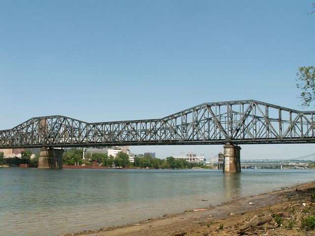
Historic American Engineering Record documentation mentioned that they believed this bridge is the second longest continuous span through truss constructed. It is unclear if this refers to when the bridge was first built or if that still held true when their documentation was completed. The bridge was built in 1929, and the Chesapeake and Ohio Railroad was the original owner. This bridge has a distinctive appearance because although its trusses are deeper over the piers, they do not come to a point like many bridges of this type. This bridge is usually described as a cantilever truss, but it is possible that this bridge may be one of those bridges that does not actually function as a cantilever truss (even if it was constructed as such) but in fact functions as a continuous truss. Closer inspection of this bridge is needed to verify this possibility.
This bridge was a replacement for a previous railroad truss bridge. When the current railroad bridge was built, the piers from this former railroad bridge were merely widened to support the new bridge. The previous bridge was left standing and converted for highway use. The railroad-turned-highway bridge was later demolished in 1970 and replaced with the current Clay Wade Bailey Bridge.

![]()
![]()
![]()
Coordinates (Latitude, Longitude):
Search For Additional Bridge Listings:
Bridgehunter.com: View listed bridges within 0.5 miles (0.8 kilometers) of this bridge.
Bridgehunter.com: View listed bridges within 10 miles (16 kilometers) of this bridge.
Additional Maps:
Google Streetview (If Available)
GeoHack (Additional Links and Coordinates)
Apple Maps (Via DuckDuckGo Search)
Apple Maps (Apple devices only)
Android: Open Location In Your Map or GPS App
Flickr Gallery (Find Nearby Photos)
Wikimedia Commons (Find Nearby Photos)
Directions Via Sygic For Android
Directions Via Sygic For iOS and Android Dolphin Browser
USGS National Map (United States Only)
Historical USGS Topo Maps (United States Only)
Historic Aerials (United States Only)
CalTopo Maps (United States Only)

© Copyright 2003-2024, HistoricBridges.org. All Rights Reserved. Disclaimer: HistoricBridges.org is a volunteer group of private citizens. HistoricBridges.org is NOT a government agency, does not represent or work with any governmental agencies, nor is it in any way associated with any government agency or any non-profit organization. While we strive for accuracy in our factual content, HistoricBridges.org offers no guarantee of accuracy. Information is provided "as is" without warranty of any kind, either expressed or implied. Information could include technical inaccuracies or errors of omission. Opinions and commentary are the opinions of the respective HistoricBridges.org member who made them and do not necessarily represent the views of anyone else, including any outside photographers whose images may appear on the page in which the commentary appears. HistoricBridges.org does not bear any responsibility for any consequences resulting from the use of this or any other HistoricBridges.org information. Owners and users of bridges have the responsibility of correctly following all applicable laws, rules, and regulations, regardless of any HistoricBridges.org information.
![]()