

View Information About HSR Ratings
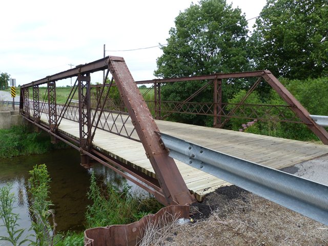
This bridge is a pin-connected pony truss of moderate length. The bridge remains open to traffic. Its historic integrity is fair, however several alterations do exist. A retrofit is present: additional rods have been added at the vertical members. The bottom chord has some welded repairs and splices. Welded repairs are also found at the base of the end posts. The bridge uses recessed nuts for the pins on the bridge, which provide the benefits of both a washer and a nut in one unit. One of the bottom chord nuts was put on backwards, likely after some repair was made to the bridge. It looks quite silly to anyone who knows how it is supposed to look!
Despite alteration, the bridge continues to offer aesthetic qualities typical of a pin-connected truss bridge, those qualities being far superior to any modern bridge.
Information and Findings From Ohio's Historic Bridge InventorySetting/Context The bridge carries a 1 lane road over a stream in a rural area of active farms. The road narrows at the bridge. Physical Description The 1 span, 61'-long, pin-connected Pratt pony truss bridge is supported on ashlar abutments. The truss lines are traditionally composed with built up box sections for the upper chords and inclined end posts. The verticals are toe-out channels with lacing, and the diagonals and lower chords are eye bars. Vertical rod helpers have been placed, and there is impacted rust at the box sections. Integrity Numerous welded repairs, including the lower portions of all end posts. Vertical helpers added. Impacted rust. Summary of Significance The date of construction of the ca. 1888 pin connected Pratt pony truss bridge is not documented in Morrow County records, but stylistically it appears to have been fabricated by the Massillon Bridge Co. It is
one of 20 examples of the important bridge type in Morrow County with the oldest extant example dating to 1874. Many are undocumented and represent the era of standardization. This example is attributed to the, who sold many truss
bridges to the county. Morrow County retains many deteriorating pin connected truss bridges largely because of the economic issues associated with there replacement in a largely rural county with no industrial tax base. This example
is not historically or technologically significant. This example has expedient repairs and is not historically or technologically significant in comparison to the county and state population of pin connected pony truss bridges. Bridge Considered Historic By Survey: No |
![]()
![]()
![]()
This historic bridge has been demolished. This map is shown for reference purposes only.
Coordinates (Latitude, Longitude):
Search For Additional Bridge Listings:
Bridgehunter.com: View listed bridges within 0.5 miles (0.8 kilometers) of this bridge.
Bridgehunter.com: View listed bridges within 10 miles (16 kilometers) of this bridge.
Additional Maps:
Google Streetview (If Available)
GeoHack (Additional Links and Coordinates)
Apple Maps (Via DuckDuckGo Search)
Apple Maps (Apple devices only)
Android: Open Location In Your Map or GPS App
Flickr Gallery (Find Nearby Photos)
Wikimedia Commons (Find Nearby Photos)
Directions Via Sygic For Android
Directions Via Sygic For iOS and Android Dolphin Browser
USGS National Map (United States Only)
Historical USGS Topo Maps (United States Only)
Historic Aerials (United States Only)
CalTopo Maps (United States Only)

© Copyright 2003-2024, HistoricBridges.org. All Rights Reserved. Disclaimer: HistoricBridges.org is a volunteer group of private citizens. HistoricBridges.org is NOT a government agency, does not represent or work with any governmental agencies, nor is it in any way associated with any government agency or any non-profit organization. While we strive for accuracy in our factual content, HistoricBridges.org offers no guarantee of accuracy. Information is provided "as is" without warranty of any kind, either expressed or implied. Information could include technical inaccuracies or errors of omission. Opinions and commentary are the opinions of the respective HistoricBridges.org member who made them and do not necessarily represent the views of anyone else, including any outside photographers whose images may appear on the page in which the commentary appears. HistoricBridges.org does not bear any responsibility for any consequences resulting from the use of this or any other HistoricBridges.org information. Owners and users of bridges have the responsibility of correctly following all applicable laws, rules, and regulations, regardless of any HistoricBridges.org information.
![]()