

View Information About HSR Ratings
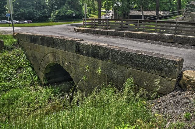
This small but unaltered and attractive stone arch bridge is located next to the remains of an old lock system.
This bridge is also near to a truss bridge.
Bridgehunter.com reported a ca. 1875 date for this bridge, although the source of that is unknown. The Historic Bridge Inventory suggests the bridge was built at the same time as the nearby truss bridge's abutments which seems plausible.
Information and Findings From Ohio's Historic Bridge InventorySetting/Context The bridge carries a 2-lane road over the tail race of Gaston's Mill in Beaver Creek State Park. The bridge is on the southern boundary of the Gaston's Mill and Lock No. 36, Sandy and Beaver Canal Historic District (NR 1974). The district includes two resources: Gaston's Mill, built around 1837, subsequently expanded, and rehabilitated as a historic site in 1964; and Lock No. 36 of the Sandy and Beaver Canal, built about 1845. The canal, which was a feeder to the Ohio & Erie Canal. was abandoned about 1852 following damage from flood and after only four years of operation. The north edge of Echo Dale Road is the southern property boundary, so the bridge is adjacent to, but not within, the NR district. Echo Dale Road is carried across Beaver Creek about 250' to the east by a 1909 pin-connected Pratt thru truss bridge that has been determined eligible (1537741). That bridge is supported on ashlar abutments similar to the ashlar that composes the arch bridge. Also within the park is a "pioneer village" composed of buildings moved to the park for preservation. Physical Description The 1-span, 21'-long, stone arch bridge has coursed ashlar arch barrel and spandrel walls. The sandstone ashlar is nicely tooled with margins. Integrity Needs repointing. Summary of Significance The stone arch bridge is estimated to date from ca. 1909 based on the similarity to the ashlar masonry in the 1909 pin-connected truss bridge over Beaver Creek. The bridge is not technologically distinguished on its own merits, but it is nicely composed and appears to be contributing to a possible expansion of the Gaston's Mill/Lock No. 36, Sandy and Beaver Canal Historic District. Full consideration of the bridge's relationship to this setting, which includes a high degree of restoration and relocation of resources beginning with the mill restoration in 1964, is beyond the scope of the historic bridge inventory. Stone arch highway bridges and culverts are not uncommon in Ohio with approximately 190 examples dating from ca. 1825 to 1940 (Phase 1A Survey, 2008). Significant examples date to the 2nd quarter of the 19th century (fewer than 26 pre-1851) and are often associated with historically important transportation routes such as the National Road and the state's early canals or railroads. Later examples may have significance on the merits of the aesthetic quality/craftsmanship of the masonry work or in association with parks, such as the stone arch bridges in Cleveland's Rockefeller Park (ca. 1897-1904) or Youngstown's Mill Creek Park (ca. 1913). Stone arch culverts have roadways on earth fill atop the arch, which may or may not have headwalls, but they are the same traditional technology as arch bridges that have spandrel walls and parapets. "The immigrants who settled America came from European countries where masonry arch bridge construction was well established. Our most distinctive collection of stone arch bridges are found on the early, eastern trunkline railroads such as the B&O and Erie railroads. Early turnpikes such as the National Road had impressive stone arch bridges in Maryland. Along the road in Ohio, the famous S-bridges were built. Canals such as the Erie and the Chesapeake & Ohio had stone arch aqueducts. The technology of stone arch construction is ancient. Increased use of metal truss bridges from the late 1800s into the early twentieth century, led to a decline in stone arch bridge construction. The strength and durability of stone arch bridges made them popular. Generally, stone arch bridges built during the nineteenth century are found today in areas where good stone was available. Stone arches were common in the first half of the nineteenth century, and a number of these structures still exist. Stone arch bridges from the late eighteenth and first half of the nineteenth century are highly significant if they retain their character-defining features, which include the arch ring with keystone, barrel, spandrel wall, parapet, headwalls and abutments/wingwalls. Piers may also be a character-defining feature. Many of these stone arch structures possess both engineering and historical significance for their associations with the work programs of the Great 1930s. Stone arch bridges that do not fit within these areas (early, Depression-era, association with parks) generally possess less significance, but are still significant." [From: A Context for Common Historic Bridge Types by Parsons Brinckerhoff, October 2005] Justification A well represented bridge type throughout the state for both bridges and culverts, stone arch bridges date from the mid 1830s and the building of the National Road through Belmont Co. Many are superbly proportioned and constructed by local contractors. They were built through World War I, particularly during the later years in park settings. More than 125 examples remain. This example has moderate significance based on its date of construction, detailing, and historic contexts). Bridge Considered Historic By Survey: Yes |
![]()
![]()
![]()
Coordinates (Latitude, Longitude):
Search For Additional Bridge Listings:
Bridgehunter.com: View listed bridges within 0.5 miles (0.8 kilometers) of this bridge.
Bridgehunter.com: View listed bridges within 10 miles (16 kilometers) of this bridge.
Additional Maps:
Google Streetview (If Available)
GeoHack (Additional Links and Coordinates)
Apple Maps (Via DuckDuckGo Search)
Apple Maps (Apple devices only)
Android: Open Location In Your Map or GPS App
Flickr Gallery (Find Nearby Photos)
Wikimedia Commons (Find Nearby Photos)
Directions Via Sygic For Android
Directions Via Sygic For iOS and Android Dolphin Browser
USGS National Map (United States Only)
Historical USGS Topo Maps (United States Only)
Historic Aerials (United States Only)
CalTopo Maps (United States Only)

© Copyright 2003-2024, HistoricBridges.org. All Rights Reserved. Disclaimer: HistoricBridges.org is a volunteer group of private citizens. HistoricBridges.org is NOT a government agency, does not represent or work with any governmental agencies, nor is it in any way associated with any government agency or any non-profit organization. While we strive for accuracy in our factual content, HistoricBridges.org offers no guarantee of accuracy. Information is provided "as is" without warranty of any kind, either expressed or implied. Information could include technical inaccuracies or errors of omission. Opinions and commentary are the opinions of the respective HistoricBridges.org member who made them and do not necessarily represent the views of anyone else, including any outside photographers whose images may appear on the page in which the commentary appears. HistoricBridges.org does not bear any responsibility for any consequences resulting from the use of this or any other HistoricBridges.org information. Owners and users of bridges have the responsibility of correctly following all applicable laws, rules, and regulations, regardless of any HistoricBridges.org information.
![]()