

View Information About HSR Ratings
The National Bridge Inventory gave a 1932 date for this bridge, which is clearly incorrect, as such pin-connected structures as this one would undoubtedly date to 1915 or older. The bridge may have been relocated here in 1932. This bridge features eight panels. Original railings do not remain on the bridge and the portal bracing is not original. However, the overall appearance of the bridge remains attractive, and the remainder of the structure retains an acceptable level of integrity. Also, pin-connected Camelback truss bridges are a rare variety of pin-connected truss bridge in Ohio, and the bridge should be given additional significance on this account.
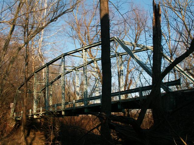
Information and Findings From Ohio's Historic Bridge InventorySetting/Context The bridge carries a 1 lane road over a stream in a rural setting. At the southeast quadrant is a 1.5-story frame building with sheet-metal gambrel roof; a sign identifies it as "Giant Oak Mill, est. 1803." A period farmhouse is beyond the southeast quadrant. Another period farm complex is beyond the northeast quadrant. At the northwest end of the bridge is a T-shaped intersection. Physical Description The 1 span, 131'-long, pin-connected, eight-panel, Camelback thru truss bridge is traditionally composed with built-up compression members and eyebar tension members. The upper chords are toe-out channels with cover plate and battens. The verticals are toe-out channels with lacing. The lower chords and diagonals are eyebars. The upper-lateral braces are T-sections with rod crossbracing. The portal bracing is non-original welded channel sections. The floorbeams are suspended from the lower panel points by U-shaped hangers. The floorbeams carry steel stringers and a wood deck. The bridge is supported on concrete abutments. Integrity Deck and original lattice railings replaced in 1994. Lower-chord eyebars, end-panel floorbeam hangers, and diagonals irreversibly altered by welded repairs and welded strengthening at the lower panel points. Portal bracing replaced with welded channels. Summary of Significance The Camelback thru truss bridge dates ca. 1905 by style but is reported as built in 1932 by county records, which probably indicates the bridge was relocated here in 1932. The bridge has no unusual or
technologically distinguishing features for an early 20th century, pin-connected truss. Its integrity of design has been significantly compromised by the welded repairs to the lower panel points. These repairs are irreversible and
have changed the way the truss functions at the pin connections. More complete and distinguished examples of this type/design better represent the significance of the technology. Bridge Considered Historic By Survey: No |
![]()
![]()
This historic bridge has been demolished. This map is shown for reference purposes only.
Coordinates (Latitude, Longitude):
Search For Additional Bridge Listings:
Bridgehunter.com: View listed bridges within 0.5 miles (0.8 kilometers) of this bridge.
Bridgehunter.com: View listed bridges within 10 miles (16 kilometers) of this bridge.
Additional Maps:
Google Streetview (If Available)
GeoHack (Additional Links and Coordinates)
Apple Maps (Via DuckDuckGo Search)
Apple Maps (Apple devices only)
Android: Open Location In Your Map or GPS App
Flickr Gallery (Find Nearby Photos)
Wikimedia Commons (Find Nearby Photos)
Directions Via Sygic For Android
Directions Via Sygic For iOS and Android Dolphin Browser
USGS National Map (United States Only)
Historical USGS Topo Maps (United States Only)
Historic Aerials (United States Only)
CalTopo Maps (United States Only)

© Copyright 2003-2024, HistoricBridges.org. All Rights Reserved. Disclaimer: HistoricBridges.org is a volunteer group of private citizens. HistoricBridges.org is NOT a government agency, does not represent or work with any governmental agencies, nor is it in any way associated with any government agency or any non-profit organization. While we strive for accuracy in our factual content, HistoricBridges.org offers no guarantee of accuracy. Information is provided "as is" without warranty of any kind, either expressed or implied. Information could include technical inaccuracies or errors of omission. Opinions and commentary are the opinions of the respective HistoricBridges.org member who made them and do not necessarily represent the views of anyone else, including any outside photographers whose images may appear on the page in which the commentary appears. HistoricBridges.org does not bear any responsibility for any consequences resulting from the use of this or any other HistoricBridges.org information. Owners and users of bridges have the responsibility of correctly following all applicable laws, rules, and regulations, regardless of any HistoricBridges.org information.
![]()