

View Information About HSR Ratings
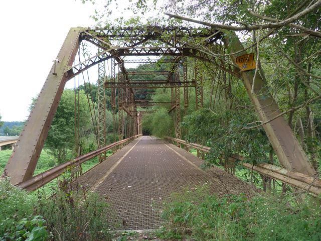
This bridge has been bypassed and abandoned, but can still be walked on by visitors. It is a late example of its type, but pin-connected truss bridges, especially multi-span examples of any age are rare. This bridge is therefore historically significant. It is also noted for the lack of alteration.
This bridge is located on a part of the river that is close to the Mohawk Resevoir. As such, it appears that during high water events the water level can rise dramatically at this location. There is evidence that the water has at times reached as high as halfway up the height of the truss... a large tree trunk was stuck between a pair of eyebars near one of the intermediate connections of the truss! Some of the trees in the surrounding area also had flood debris stuck in them at a similar elevation.
Information and Findings From Ohio's Historic Bridge InventorySetting/Context The bridge once carried a 2-lane state highway over a river in a rural, wooded setting. It has been bypassed by a modern road to the north, but it is accessible for pedestrian use. There is a parking area at the west end of the bridge, which is closed to traffic and bypassed, is located in a rural setting. Physical Description The 2 span, 406'-long, pin-connected Pennsylvania thru truss bridge has built-up compression members and eyebar tension members. Integrity Bypassed, ca. 2004 and left in place. The only observed change from the original design is the steel open grid deck. Summary of Significance "The 1914 pin-connected Pennsylvania thru truss bridge is a later but complete example of its type/design with typical period details. The bridge has been bypassed and left in place. There have been no significant changes to the integrity of design or materials since the prior inventory and the bridge was last field checked by ODOT in 2006. It is eligible from the prior ODOT inventory. The Pennsylvania truss type/design, also sometimes referred to as a Pettit truss, is a subdivided Pratt truss with polygonal upper chord that was developed in the 1870s for use as a long-span bridge with heavy locomotives. The Pennsylvania Railroad popularized the form (hence the name), and Henry Pettit, an engineer in the employ of the railroad, became associated with it. It was not, however, used exclusively by the Pennsylvania RR being a very popular railroad and later highway truss design. Lighter pin-connected Pennsylvania truss highway bridges were built from the 1880s to 1910s, and the design also made the transition to heavier, rivet-connected designs of the mid 20th century. The truss's main advantages are an economical use of material provided by the sloped upper chord and the added stiffness provided by the substruts and ties in longer spans. Span lengths of up to 300 ft. are not uncommon. Ohio has eight identified examples dating from 1888 to 1939. Post-1900 examples are less significant than earlier examples, but they may illustrate important refinements, such as the use of riveted connections or rolled section members." Justification The late example of a pin connected thru truss is one of 13 extant examples of bridges with polygonal upper chords and/or subdivided panels in the state that date from 1888 until 1923. It is of moderate significance given that the numbers in the population. Bridge Considered Historic By Survey: Yes |
![]()
![]()
![]()
Coordinates (Latitude, Longitude):
Search For Additional Bridge Listings:
Bridgehunter.com: View listed bridges within 0.5 miles (0.8 kilometers) of this bridge.
Bridgehunter.com: View listed bridges within 10 miles (16 kilometers) of this bridge.
Additional Maps:
Google Streetview (If Available)
GeoHack (Additional Links and Coordinates)
Apple Maps (Via DuckDuckGo Search)
Apple Maps (Apple devices only)
Android: Open Location In Your Map or GPS App
Flickr Gallery (Find Nearby Photos)
Wikimedia Commons (Find Nearby Photos)
Directions Via Sygic For Android
Directions Via Sygic For iOS and Android Dolphin Browser
USGS National Map (United States Only)
Historical USGS Topo Maps (United States Only)
Historic Aerials (United States Only)
CalTopo Maps (United States Only)

© Copyright 2003-2024, HistoricBridges.org. All Rights Reserved. Disclaimer: HistoricBridges.org is a volunteer group of private citizens. HistoricBridges.org is NOT a government agency, does not represent or work with any governmental agencies, nor is it in any way associated with any government agency or any non-profit organization. While we strive for accuracy in our factual content, HistoricBridges.org offers no guarantee of accuracy. Information is provided "as is" without warranty of any kind, either expressed or implied. Information could include technical inaccuracies or errors of omission. Opinions and commentary are the opinions of the respective HistoricBridges.org member who made them and do not necessarily represent the views of anyone else, including any outside photographers whose images may appear on the page in which the commentary appears. HistoricBridges.org does not bear any responsibility for any consequences resulting from the use of this or any other HistoricBridges.org information. Owners and users of bridges have the responsibility of correctly following all applicable laws, rules, and regulations, regardless of any HistoricBridges.org information.
![]()