

View Information About HSR Ratings
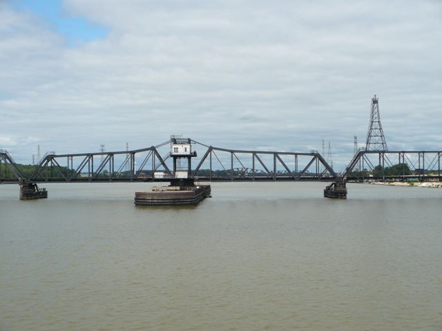
This bridge appears to have a complicated and somewhat confusing history. Reportedly, the bridge is shorter than the bridge it replaced as some length was filled in. The previous bridge was 9 spans of 177 feet each and a swing span of 340 feet. One of the spans of this previous bridge was not original and was steel and was reused in the replacement bridge. The approach truss spans of the replacement bridge are 180 feet, with the exception of the one next to the swing span on the northwest side which is 150 feet. In 1897, the March 19 issue of the Railway Age reports that Detroit Bridge and Iron Works were building the four 180 foot approach spans, but then says that the swing span had been recently rebuilt in steel and was in good condition suggesting someone else replaced that span. Another article, November 13, 1897 of the Railway and Engineering Review, states that the Edge Moor Bridge Company was building nine bridges for this railroad including the one at the Maumee River in Toledo. To the best of HistoricBridges.org's knowledge, the swing span was built by Edge Moor and the approach spans were built by Detroit Bridge and Iron Works. In 1914, the 150 foot truss span next to the swing span was pushed into the river in an accident. It may have been repaired and reused, but this is not known for sure. Thanks to John Marvig for assisting with this research.
This is one of several railroad swing bridges on the Maumee River. Each is significant as a complete, large truss bridge including extensive approach truss spans and a main swing span. This is an active bridge, and is in a location that is difficult to photograph from land. Thanks to Mr. Nietering's efforts however, photos of this bridge are brought to you from the perspective of a boat.

![]()
![]()
![]()
Coordinates (Latitude, Longitude):
Search For Additional Bridge Listings:
Bridgehunter.com: View listed bridges within 0.5 miles (0.8 kilometers) of this bridge.
Bridgehunter.com: View listed bridges within 10 miles (16 kilometers) of this bridge.
Additional Maps:
Google Streetview (If Available)
GeoHack (Additional Links and Coordinates)
Apple Maps (Via DuckDuckGo Search)
Apple Maps (Apple devices only)
Android: Open Location In Your Map or GPS App
Flickr Gallery (Find Nearby Photos)
Wikimedia Commons (Find Nearby Photos)
Directions Via Sygic For Android
Directions Via Sygic For iOS and Android Dolphin Browser
USGS National Map (United States Only)
Historical USGS Topo Maps (United States Only)
Historic Aerials (United States Only)
CalTopo Maps (United States Only)

© Copyright 2003-2024, HistoricBridges.org. All Rights Reserved. Disclaimer: HistoricBridges.org is a volunteer group of private citizens. HistoricBridges.org is NOT a government agency, does not represent or work with any governmental agencies, nor is it in any way associated with any government agency or any non-profit organization. While we strive for accuracy in our factual content, HistoricBridges.org offers no guarantee of accuracy. Information is provided "as is" without warranty of any kind, either expressed or implied. Information could include technical inaccuracies or errors of omission. Opinions and commentary are the opinions of the respective HistoricBridges.org member who made them and do not necessarily represent the views of anyone else, including any outside photographers whose images may appear on the page in which the commentary appears. HistoricBridges.org does not bear any responsibility for any consequences resulting from the use of this or any other HistoricBridges.org information. Owners and users of bridges have the responsibility of correctly following all applicable laws, rules, and regulations, regardless of any HistoricBridges.org information.
![]()