

View Information About HSR Ratings
2020 Update: As of this year, the bridge has been bypassed by a new bridge but the heritage bridge has thankfully been left standing as planned!
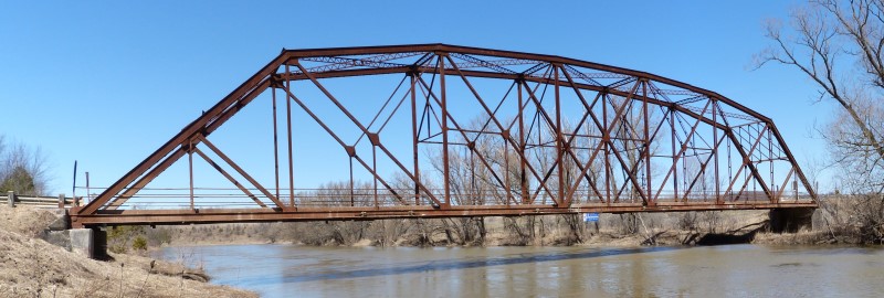
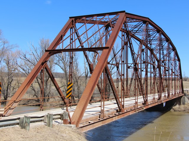
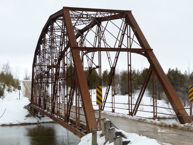
This impressive bridge is a large single span structure whose trusses rise dramatically above the roadway, punctuated by a large lattice web portal bracing. The bridge has multiple areas of historic and technological significance that combine to give this bridge an extremely high level of heritage significance. The historic integrity of the bridge appears to be good, with the replacement of some rivets with bolts appearing to be the only noteworthy alteration. The bridge's long span may be the longest surviving truss span in Bruce County, and regardless is a long truss span for southwestern Ontario. The bridge also appears to be the only surviving example of a Pennsylvania truss bridge in all of southwestern Ontario.
Overall, the bridge at first looks like it is a massive, over-built bridge. However, closer inspection shows that diagonal and vertical members are of average size for the period. The large top chord and end post are the result of the larger-than-normal span length.
The most unusual detail on the bridge lies in the bottom chord and flooring system. It is apparent that the bottom chord is extremely large and massive in comparison to the size of the other truss members and chords. The built-up bottom chord is composed of back-to-back channels with battens on the top and bottom. A closer inspection seems to reveal why the bottom chord is massive and of unusual design. This truss bridge has floorbeams at each vertical member (panel point) as is to be expected of a truss bridge. However, there are also floorbeams at each point along the bottom chord where a batten is located, in between vertical members! This design is extremely unusual to the point of being nearly unheard of. The reason for this design is not certain, however it may have to do with the fact that this bridge was built specifically to deal with a history of flooding in the area. The long-span design avoided the use of a pier in the water, allowing floodwaters to pass under the bridge unobstructed. One of the sources of flood damages to truss bridges is when debris becomes entangled with the truss, and damages the truss. The frequent placement of floorbeams on this bridge means that each floorbeam does not have to be as deep. The shallower floorbeams are able to fit within the unusually large and heavy-duty bottom chord. Because they do not extend below the bottom chord (as might have been the case with larger floorbeams placed at only the panel points), this reduces the places where flood debris can get entangled on the bridge. Further, the heavy bottom chord, being framed around each one of these floorbeams would be greatly strengthened by the floorbeams themselves. This creative design allows the bottom chord to shield the floor beams from debris while the floorbeams strengthen the bottom chord from impact damage by flood debris.
A 2013 Heritage Impact Assessment prepared for Bruce County provided the following information including the below drawing.

The Saugeen River has experienced significant flooding in its history and spring floods have continued to be a concern today. In 1915 a flood caused substantial damage upstream of the bridge at the Town of Walkerton.
The McCurdy Bridge is located on the Brant-Elderslie Road that formed the municipal boundary between Brant Township on the south and Elderslie Township to the north. Brant Township, surveyed in 1850, and Elderslie Township, surveyed in 1851 were both laid out with the 1,000 acre sectional survey system, commonly used between 1835 and 1906.
Brant Township opened for settlement in 1851 and within a year 620 people were located within the township. In 1864 the township had grown to a level that justified the establishment of a municipal government. In 1999 the Townships of Brant, Greenock, and Walkerton were reorganized to comprise the Municipality of Brockton. In 2011 Brockton had a population of 9,432.
Arran Township was surveyed on the north side of Brant Township and also opened to settlement in 1851. However settlement was far slower than in Brant and contained only 14 settlers in 1852. In 1856, Arran Township was divided into a smaller Arran Township and a new Elderslie Township. Almost 150 years later the two townships were recombined to form the Municipality of Arran-Elderslie which had a population of 6, 810 in 2011.
Ellengowan was the closest rural hamlet to the bridge and was located at the intersection of Brant-Elderslie Road and Bruce Road A post office was established in 1858 and by 1886, the community had a population of 100. The post office closed in 1910 and the community gradually disappeared.
The 19th century land surveys placed a gridiron road pattern on the landscape. The surveys were undertaken without regard to topographical features. The location of the McCurdy Bridge illustrates the problems that could arise.
The original township survey placed the Township line down a very steep slope of the west wall of the Saugeen River that would have been impossible to use as a road. Therefore the County of Bruce in the 1860s purchased a portion of land from Mr. McCurdy in order to relocate the road slightly north of the survey land and obtain a better approach to the river.
The date of the first bridge over the Saugeen River on Brant-Elderslie Road was not determined. In 1864 a bridge was reportedly damaged by a log jam. Although plans for a new bridge were initiated in 1868 it was not completed until 1872. This structure underwent major repairs in 1880, 1883, and 1885 and was replaced with yet another timber bridge in 1886. Damage caused by a log jam in 1897 resulted in the construction of yet another bridge in 1898. By 1913 the Bruce County Road and Bridge Committee described the bridge as in a very dangerous condition and planning commenced on a new bridge.
The Saugeen River was over 200 feet wide at the bridge crossing. Earlier bridges had short spans and required intermediate piers placed in the river. These piers were very vulnerable to ice shoves and log jams. The remains of an earlier timber crib pier are still evident on the south side of the McCurdy Bridge.
As noted above, the Bridge Committee chose a Pennsylvania truss design for the bridge. This enabled the river to be crossed without intermediate piers. The bridge was 215 feet with a deck width of 15 feet. It was built two feet higher above the Saugeen than the 1898 bridge in order to reduce the flood risk.
In common with bridge building practices of the era, the abutments were built by one company and the bridge structure by another firm. The County engineer coordinated the work. The contract for the concrete abutments was awarded to R. Beggs of Port Elgin at a cost of $3,000. The contract for the superstructure was awarded to the Standard Steel Construction Company of Port Robinson, Ontario at a cost of $11,500.
As with most of the small bridge building companies in Ontario, little is known about the history of the Standard Steel Construction Company. It was in existence in 1913. Standard Steel was still in existence in 1934 when the United Steel Corporation tried to acquire it. The company was eventually acquired by James Steel in 1966 and closed in 1971.
The bridge was expected to open in August of 1913; however, construction of the superstructure was delayed. The substructure abutments constructed by Beggs were finished by August, but the truss was not complete until December. By December 26, 1913, the bridge was complete and reported by the Building Committee for Bruce County as "one of the finest bridges in the Province of Ontario."
The steel trusses were fabricated in Port Robinson and erected on site by the Standard Steel Construction Company. The trusses were assembled with rivet and pin connections.
This bridge was at risk for demolition but fortunately Bruce County saw the value of preserving this bridge. As of 2017, the plan is to bypass this heritage bridge with a new bridge for vehicular traffic, and leave this heritage bridge standing for pedestrian use. This is an outstanding preservation outcome that will ensure the long-term future of the heritage bridge while also providing for the needs of traffic in the area. Bruce County deserves to be thanked for making a good decision in favor of preservation of one of the finest heritage bridges in Ontario. This bridge stands out as one of the most unusual, impressive, and significant examples. Span length, historic integrity, uncommon truss configuration, and unusual flooring and deck design all combine to make this bridge highly significant.

![]()
![]()
![]()
![]()
![]()
Coordinates (Latitude, Longitude):
Search For Additional Bridge Listings:
Additional Maps:
Google Streetview (If Available)
GeoHack (Additional Links and Coordinates)
Apple Maps (Via DuckDuckGo Search)
Apple Maps (Apple devices only)
Android: Open Location In Your Map or GPS App
Flickr Gallery (Find Nearby Photos)
Wikimedia Commons (Find Nearby Photos)
Directions Via Sygic For Android
Directions Via Sygic For iOS and Android Dolphin Browser

© Copyright 2003-2024, HistoricBridges.org. All Rights Reserved. Disclaimer: HistoricBridges.org is a volunteer group of private citizens. HistoricBridges.org is NOT a government agency, does not represent or work with any governmental agencies, nor is it in any way associated with any government agency or any non-profit organization. While we strive for accuracy in our factual content, HistoricBridges.org offers no guarantee of accuracy. Information is provided "as is" without warranty of any kind, either expressed or implied. Information could include technical inaccuracies or errors of omission. Opinions and commentary are the opinions of the respective HistoricBridges.org member who made them and do not necessarily represent the views of anyone else, including any outside photographers whose images may appear on the page in which the commentary appears. HistoricBridges.org does not bear any responsibility for any consequences resulting from the use of this or any other HistoricBridges.org information. Owners and users of bridges have the responsibility of correctly following all applicable laws, rules, and regulations, regardless of any HistoricBridges.org information.
![]()