


View Information About HSR Ratings
Additional Information: Robert McAlpine Limited of Weston, Ontario was the substructure contractor for the bridge.

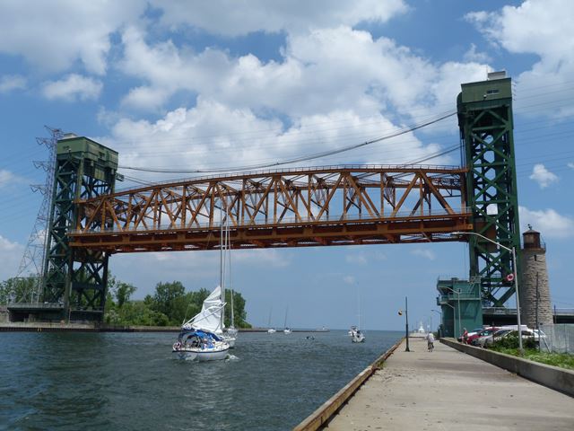
This bridge, completed in 1962, is a late example of a vertical lift bridge. However, the bridge is nevertheless old enough so that it has details not found on modern bridges like built-up beams with rivets as well as lattice bars (those being found in the bracing). In contrast, some built-up members (particularly those in the truss web) use plate with holes in place of lattice, a variety typical of 1950s and 1960s bridges. The bridge is also significant for its very long lift span, a length unequaled by most older lift bridges.
The bridge is not the first at this location. A swing bridge was once located at this crossing. In 1922, this was replaced by a single leaf Strauss heel-trunnion type bascule. An interesting story about this bridge is that in 1931 the canal was widened, and to accommodate this, a second bascule bridge was added at the other side of the canal to form a double leaf bascule bridge. On April 29, 1952, the freighter W. E. Fitzgerald collided with and destroyed one of the spans, which led to the design and construction of the existing lift bridge. The lift bridge superstructure was built by the company that is generally known as the Hamilton Bridge Company but changed its name many times over its operation and at the time was officially called the Hamilton Bridge and Tank Company. The buildings for the bridge were built by McAlpine Construction Company. The lift bridge was the longest and heaviest in Canada when completed. The lift span weight when completed was 2,100 tons. The bridge was designed for a single railway track of the Hamilton-Northwestern railway as well as a two lane roadway. In 1982, the tracks were removed, and the roadway was widened. The current weight of the lift span is 2200 tons (2000 tonnes).
The bridge has a vertical lift capacity of of 110 feet (33.5 meters). There is one 150 hp drive motor in each of the two towers to raise and lower the bridge, and an additional 150 hp motor in each tower to synchronize the drive motors in each tower. The bridge continues to operate for boats frequently. In 2004, the average lifts per year was reported as 4200 lifts.
The designer of this bridge, C. C. Parker and Associates is today part of Stantec Consulting.

This bridge is tagged with the following special condition(s): Unorganized Photos
![]()

![]()
![]()
![]()
![]()

![]()
![]()
Coordinates (Latitude, Longitude):
Search For Additional Bridge Listings:
Additional Maps:
Google Streetview (If Available)
GeoHack (Additional Links and Coordinates)
Apple Maps (Via DuckDuckGo Search)
Apple Maps (Apple devices only)
Android: Open Location In Your Map or GPS App
Flickr Gallery (Find Nearby Photos)
Wikimedia Commons (Find Nearby Photos)
Directions Via Sygic For Android
Directions Via Sygic For iOS and Android Dolphin Browser

© Copyright 2003-2024, HistoricBridges.org. All Rights Reserved. Disclaimer: HistoricBridges.org is a volunteer group of private citizens. HistoricBridges.org is NOT a government agency, does not represent or work with any governmental agencies, nor is it in any way associated with any government agency or any non-profit organization. While we strive for accuracy in our factual content, HistoricBridges.org offers no guarantee of accuracy. Information is provided "as is" without warranty of any kind, either expressed or implied. Information could include technical inaccuracies or errors of omission. Opinions and commentary are the opinions of the respective HistoricBridges.org member who made them and do not necessarily represent the views of anyone else, including any outside photographers whose images may appear on the page in which the commentary appears. HistoricBridges.org does not bear any responsibility for any consequences resulting from the use of this or any other HistoricBridges.org information. Owners and users of bridges have the responsibility of correctly following all applicable laws, rules, and regulations, regardless of any HistoricBridges.org information.
![]()