

View Information About HSR Ratings
Update: This bridge is now located at the following coordinates: 42.932372, -80.305995
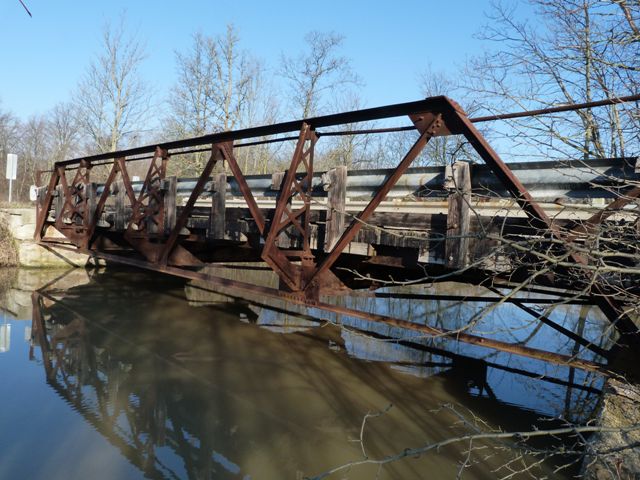
This is a tiny pony truss and due to its short length it also has shallow trusses, making it hard to tell it is a pony truss as a driver approaches it from the distance. However, from up close, the bridge is an attractive example of a small-scale truss bridge. Although modern railings have been added, original pipe railings remain and the truss itself is unaltered.
Like many bridges, this bridge was named after a farmer who had land in the area around the bridge. In this case it was Leo Miedema.
In 2012, this bridge became one of the first heritage bridges in Ontario to be relocated and reused on a pedestrian trail. HistoricBridges.org is excited at the preservation of this heritage bridge and hopes it will serve as a model for future preservation in Ontario.
Karen Lindsey, Secretary for the redevelopment committee provided the following insights into the project:
-Truly the arrangement was a win win for both the beautiful steel pony bridge and our group...the Waterford Rail Lands Redevelopment Committee.
-It was staff...more particularly Ryan Elliot at Vallee Engineering
that planted the seeds for this relocation and Andy Kooistra our chairman jumped in hands and feet!!!
-As a group we are awaiting written confirmation from the various government ministries to reinstall the bridge on the Toronto Hamilton
Buffalo (TH&B) line just west of Waterford under the "Black Bridge" which was part of the Lake Erie & Northern Electric Rail Line and now part of the Trans Canada Rail Trail.


Above Left: The bridge being lifted off of its abutments. Above Right: The bridge being lowered to its resting spot. Photo Credit: Karen Lindsey
![]()
![]()
![]()
This historic bridge has been relocated and is no longer at this location. See the main bridge page for a link to the new bridge location. This map is shown for reference purposes only.
Coordinates (Latitude, Longitude):
Search For Additional Bridge Listings:
Additional Maps:
Google Streetview (If Available)
GeoHack (Additional Links and Coordinates)
Apple Maps (Via DuckDuckGo Search)
Apple Maps (Apple devices only)
Android: Open Location In Your Map or GPS App
Flickr Gallery (Find Nearby Photos)
Wikimedia Commons (Find Nearby Photos)
Directions Via Sygic For Android
Directions Via Sygic For iOS and Android Dolphin Browser

© Copyright 2003-2024, HistoricBridges.org. All Rights Reserved. Disclaimer: HistoricBridges.org is a volunteer group of private citizens. HistoricBridges.org is NOT a government agency, does not represent or work with any governmental agencies, nor is it in any way associated with any government agency or any non-profit organization. While we strive for accuracy in our factual content, HistoricBridges.org offers no guarantee of accuracy. Information is provided "as is" without warranty of any kind, either expressed or implied. Information could include technical inaccuracies or errors of omission. Opinions and commentary are the opinions of the respective HistoricBridges.org member who made them and do not necessarily represent the views of anyone else, including any outside photographers whose images may appear on the page in which the commentary appears. HistoricBridges.org does not bear any responsibility for any consequences resulting from the use of this or any other HistoricBridges.org information. Owners and users of bridges have the responsibility of correctly following all applicable laws, rules, and regulations, regardless of any HistoricBridges.org information.
![]()