

View Information About HSR Ratings
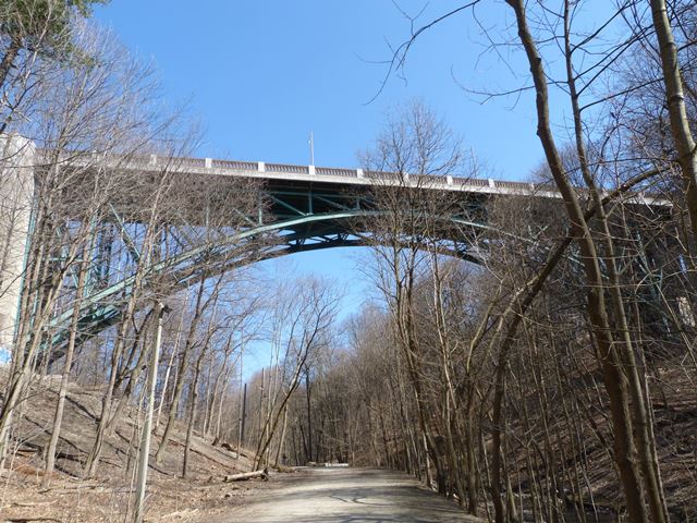
As of August, 2015 when this bridge was added to HistoricBridges.org, information and photos of this bridge on the Internet were nearly non-existent. One of the reasons might be because to see the impressive structure you have to venture under this bridge, perhaps using the trailway that follows Yellow Creek under this bridge, and you would need to do so during a time when the leaves are off the trees. Otherwise this bridge (which is buried in the woods) would be nearly impossible to see or photograph.
Hopefully this page will inspire greater awareness and discussion of this bridge. This bridge is in fact one of the most impressive bridges in Toronto, and should be considered a heritage bridge of high significance for its uncommon design, and excellent historic integrity due to lack of alteration.
The bridge consists of an impressive main steel deck arch span of roughly 94.5 meters (estimate) and with a substantial height above the valley floor. This span is a single hinge arch design, with the crown hinge at the center of the span clearly visible. The arch consists of three ribs. Ribs, members, and bracing are riveted built-up beams and include v-lacing, lattice, and battens.
A short series of steel deck plate girder spans form an approach at each end. These approach spans include arched fascia girders for aesthetic treatment, and their design appears to be concrete encased steel girders.

Above: Undated historical photo showing bridge. Source: virtualreferencelibrary.ca

Above: Historical photo showing bridge construction. Source: virtualreferencelibrary.ca
The existing bridge is apparently the third at this location. The previous bridge is documented in several historical photographs shown and discussed below. It was a beam or girder bridge, supported by riveted steel bents, sometimes called "towers" as the design was called by railways (who often used this design to span valleys) the "tower and girder" style of bridge.

The above photo, dated 1907, shows the deck of the previous bridge, including its ornamental lattice railing.

This 1915 photo shows the previous bridge from the valley below.

This 1927 photo shows the demolition of the previous bridge as part of the construction of the steel arch bridge.
![]()
![]()
![]()
Coordinates (Latitude, Longitude):
Search For Additional Bridge Listings:
Additional Maps:
Google Streetview (If Available)
GeoHack (Additional Links and Coordinates)
Apple Maps (Via DuckDuckGo Search)
Apple Maps (Apple devices only)
Android: Open Location In Your Map or GPS App
Flickr Gallery (Find Nearby Photos)
Wikimedia Commons (Find Nearby Photos)
Directions Via Sygic For Android
Directions Via Sygic For iOS and Android Dolphin Browser

© Copyright 2003-2024, HistoricBridges.org. All Rights Reserved. Disclaimer: HistoricBridges.org is a volunteer group of private citizens. HistoricBridges.org is NOT a government agency, does not represent or work with any governmental agencies, nor is it in any way associated with any government agency or any non-profit organization. While we strive for accuracy in our factual content, HistoricBridges.org offers no guarantee of accuracy. Information is provided "as is" without warranty of any kind, either expressed or implied. Information could include technical inaccuracies or errors of omission. Opinions and commentary are the opinions of the respective HistoricBridges.org member who made them and do not necessarily represent the views of anyone else, including any outside photographers whose images may appear on the page in which the commentary appears. HistoricBridges.org does not bear any responsibility for any consequences resulting from the use of this or any other HistoricBridges.org information. Owners and users of bridges have the responsibility of correctly following all applicable laws, rules, and regulations, regardless of any HistoricBridges.org information.
![]()