

View Information About HSR Ratings
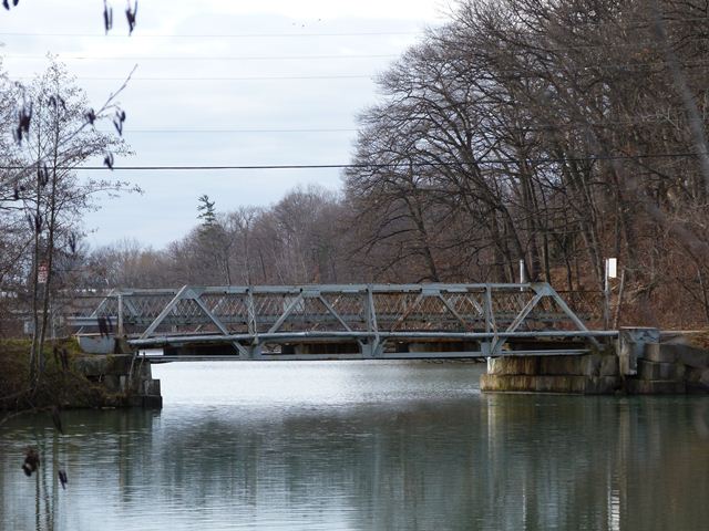
This bridge is a small traditionally composed riveted pony truss bridge. The bridge was built in 1921 to serve an unknown road at an unknown location and relocated and reused here in this location in 1958 where it is the only bridge to Henley Island located in the middle of Martindale Pond. Relocation and reuse of metal truss bridges has historically been somewhat common because the bridge type is easy to relocate. In the past (such as when this bridge was moved) it was done because it was economical. Today, it is often done in the name of historic preservation.
The bridge does have some alterations, specifically some of the members and gusset plates have some new steel welded on to them. The deck is currently a metal grate deck. The deck was likely originally concrete. Decks are not a important part of a heritage truss bridge's significance however so this is not a problematic alteration. In general, the bridge retains its original materials and design.
This bridge and the island it leads to appears to be owned entirely by the Canadian Henley Rowing Corporation, which manages the Royal Canadian Henley Regatta. This is likely a blessing, because if this bridge was owned by the Region of Niagara it would likely be demolished and replaced with an unsightly slab of concrete, a fate many pony truss bridges in the Region of Niagara have suffered or will soon suffer. This is one of the few pony truss bridges in the region that appears to have a preservation commitment.

Above: Photo of replacement bridge with remnants of truss bridge abutments visible underneath. Photo Credit: Ed Blasinski

Above: Photo of replacement bridge with remnants of truss bridge abutments visible underneath. Photo Credit: Ed Blasinski

Above: Photo of replacement bridge with remnants of truss bridge abutments visible underneath. Photo Credit: Ed Blasinski
![]()
![]()
![]()
This historic bridge has been demolished. This map is shown for reference purposes only.
Coordinates (Latitude, Longitude):
Search For Additional Bridge Listings:
Additional Maps:
Google Streetview (If Available)
GeoHack (Additional Links and Coordinates)
Apple Maps (Via DuckDuckGo Search)
Apple Maps (Apple devices only)
Android: Open Location In Your Map or GPS App
Flickr Gallery (Find Nearby Photos)
Wikimedia Commons (Find Nearby Photos)
Directions Via Sygic For Android
Directions Via Sygic For iOS and Android Dolphin Browser

© Copyright 2003-2024, HistoricBridges.org. All Rights Reserved. Disclaimer: HistoricBridges.org is a volunteer group of private citizens. HistoricBridges.org is NOT a government agency, does not represent or work with any governmental agencies, nor is it in any way associated with any government agency or any non-profit organization. While we strive for accuracy in our factual content, HistoricBridges.org offers no guarantee of accuracy. Information is provided "as is" without warranty of any kind, either expressed or implied. Information could include technical inaccuracies or errors of omission. Opinions and commentary are the opinions of the respective HistoricBridges.org member who made them and do not necessarily represent the views of anyone else, including any outside photographers whose images may appear on the page in which the commentary appears. HistoricBridges.org does not bear any responsibility for any consequences resulting from the use of this or any other HistoricBridges.org information. Owners and users of bridges have the responsibility of correctly following all applicable laws, rules, and regulations, regardless of any HistoricBridges.org information.
![]()