

View Information About HSR Ratings

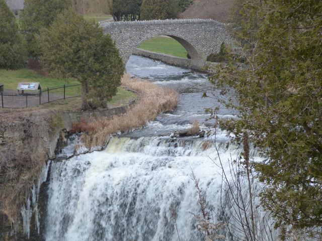
This attractive arch bridge which was built to carry pedestrians in a park setting is located on the creek right upstream of a beautiful waterfall. The bridge has the appearance of a stone bridge but it is assumed that the bridge is actually a concrete arch bridge with stone facing. The reason for this assumption is that the stones found on the surface of the bridge are too small and not locked together tightly enough to provide any load-bearing ability. Also, the bridge was built in 1938, and the practice of facing concrete arch bridges with stone was often done with park bridges built during this period. The bridge was built in the place of a dam that was built here in 1905 for the use of area mills. When the bridge was built, stone abutments from the dam were incorporated into the bridge. These stones can be seen on the ends of the abutments on the east side of the bridge. Unlike the stones on the bridge itself, these are large stones carefully placed to provide structural value. They provide an interesting contrast to the small cobblestones of the bridge. The bridge deck is surfaced in flagstone.
The Estate of Col W.E.S. Knowles provided funds for the construction of this bridge. The bridge was not maintained and eventually deteriorated to the point that it was closed to traffic. The bridge was rehabilitated in 2000 by the Optimist Club of Greensville and reopened. The bridge remains in good condition today, and appears to be maintained more carefully. For example, in June, 2012, the bridge closed for a few days to repair the flagstone deck.
Norm Van Bergen contacted HistoricBridges.org and provided the following information:
My father told me, before he passed away, that HIS dad built this bridge. My grandfather, Walter Van Bergen, was a master stonemason from Holland who emigrated to Canada. His work is present in many homes in the area, and in this case, a bridge as well. I can't attest that he was the only person who worked on the bridge, but he was certainly a key contributor to its design and construction. I'm afraid I don't know the company that he worked for.
There are three bridges in Webster's Falls Park: the Cobblestone Bridge, a stone-faced steel girder bridge, and a concrete rigid-frame bridge.

![]()
![]()
![]()
Coordinates (Latitude, Longitude):
Search For Additional Bridge Listings:
Additional Maps:
Google Streetview (If Available)
GeoHack (Additional Links and Coordinates)
Apple Maps (Via DuckDuckGo Search)
Apple Maps (Apple devices only)
Android: Open Location In Your Map or GPS App
Flickr Gallery (Find Nearby Photos)
Wikimedia Commons (Find Nearby Photos)
Directions Via Sygic For Android
Directions Via Sygic For iOS and Android Dolphin Browser

© Copyright 2003-2024, HistoricBridges.org. All Rights Reserved. Disclaimer: HistoricBridges.org is a volunteer group of private citizens. HistoricBridges.org is NOT a government agency, does not represent or work with any governmental agencies, nor is it in any way associated with any government agency or any non-profit organization. While we strive for accuracy in our factual content, HistoricBridges.org offers no guarantee of accuracy. Information is provided "as is" without warranty of any kind, either expressed or implied. Information could include technical inaccuracies or errors of omission. Opinions and commentary are the opinions of the respective HistoricBridges.org member who made them and do not necessarily represent the views of anyone else, including any outside photographers whose images may appear on the page in which the commentary appears. HistoricBridges.org does not bear any responsibility for any consequences resulting from the use of this or any other HistoricBridges.org information. Owners and users of bridges have the responsibility of correctly following all applicable laws, rules, and regulations, regardless of any HistoricBridges.org information.
![]()