

View Information About HSR Ratings
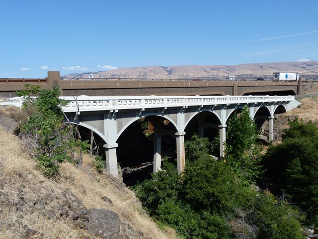
This bridge is one of the wide variety of aesthetics-focused bridges that were built for the historic Columbia River Highway. This one is noted for its spans with arched facades which conceal a more utilitarian structure within.
Information and Findings From Oregon's Historic Bridge InventoryGeneral Description of Columbia River Highway The building of the Columbia River Highway was the first concerted highway building effort of the newly created Oregon State Highway Commission in cooperation with the counties through which it passed. Championed by a number of notable Oregonian's, including Simon Benson, John B. Yeon, Samuel Hill, Julius Meier and Rufus Holman, they promoted the highway as both an important link between the east and west of Oregon and as a scenic route, showing off the beautiful Columbia River Gorge. In order to match the scenic qualities of the Gorge and meet the most modern highway standards of the day, the many bridges required along the route were designed to be both graceful and strong. To accomplish this at each site, the engineers created a wide variety of bridge types, including many concrete deck arches, often designed to be viewed from pedestrian lookouts. Together, the 25 bridges and viaducts stretching across three counties comprise one of the best collections of reinforced concrete structures in America. The bridges in Wasco County were among the last to be built and show many of the characteristic features of McCullough designs. Description of Bridge Six 40-ft reinforced concrete girder spans with arched facades, curved pier caps and bush hammered panels Designer C.B. McCullough (State Bridge Engineer), L.W. Metzger (Design Engineer) Character Defining Features Location on historic Columbia River Highway, Decorative features and railings, Structure type Bridge Considered Historic By Survey: Yes |
![]()
![]()
![]()
Coordinates (Latitude, Longitude):
Search For Additional Bridge Listings:
Bridgehunter.com: View listed bridges within 0.5 miles (0.8 kilometers) of this bridge.
Bridgehunter.com: View listed bridges within 10 miles (16 kilometers) of this bridge.
Additional Maps:
Google Streetview (If Available)
GeoHack (Additional Links and Coordinates)
Apple Maps (Via DuckDuckGo Search)
Apple Maps (Apple devices only)
Android: Open Location In Your Map or GPS App
Flickr Gallery (Find Nearby Photos)
Wikimedia Commons (Find Nearby Photos)
Directions Via Sygic For Android
Directions Via Sygic For iOS and Android Dolphin Browser
USGS National Map (United States Only)
Historical USGS Topo Maps (United States Only)
Historic Aerials (United States Only)
CalTopo Maps (United States Only)

© Copyright 2003-2024, HistoricBridges.org. All Rights Reserved. Disclaimer: HistoricBridges.org is a volunteer group of private citizens. HistoricBridges.org is NOT a government agency, does not represent or work with any governmental agencies, nor is it in any way associated with any government agency or any non-profit organization. While we strive for accuracy in our factual content, HistoricBridges.org offers no guarantee of accuracy. Information is provided "as is" without warranty of any kind, either expressed or implied. Information could include technical inaccuracies or errors of omission. Opinions and commentary are the opinions of the respective HistoricBridges.org member who made them and do not necessarily represent the views of anyone else, including any outside photographers whose images may appear on the page in which the commentary appears. HistoricBridges.org does not bear any responsibility for any consequences resulting from the use of this or any other HistoricBridges.org information. Owners and users of bridges have the responsibility of correctly following all applicable laws, rules, and regulations, regardless of any HistoricBridges.org information.
![]()