

View Information About HSR Ratings
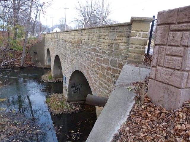
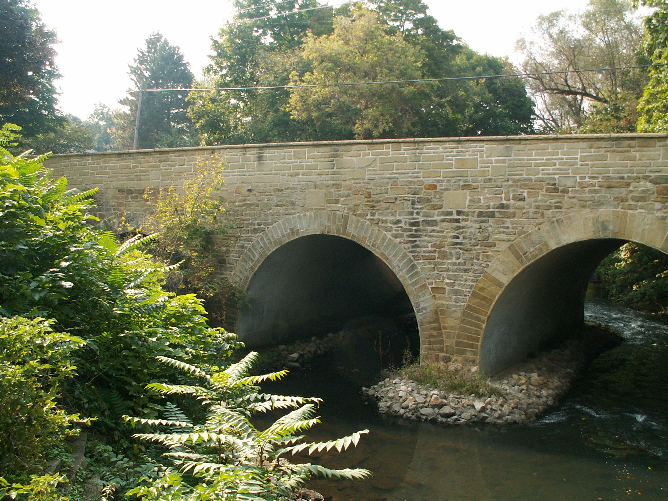
Stone arch bridges, particularly on highways, are extremely rare in Michigan. As a three-span structure, this bridge is particularly significant for its relatively long, multi-span configuration. The bridge is in fact the longest known stone highway bridge in Michigan. The bridge is three spans, but the southern span is mostly filled in with dirt for reasons which are unclear. The structure was preserved in 1995-1996 and remains today in excellent condition.
Information and Findings From Michigan Historic Bridge InventoryNarrative Description The Marshall Avenue Bridge is eligible for the National Register as an
example of a stone masonry-arch bridge, a structural type that is
extremely rare in Michigan. Information and Findings From Michigan Historic Sites OnlineNarrative Description The Marshall Avenue Bridge crosses Rice Creek in a residential neighborhood in the city of Marshall, the county seat of Calhoun County. The bridge is comprised of three twenty-five foot stone-arch spans. The structure's random range work rises to create solid railings along the forty-two foot wide deck, which holds two sidewalks and a thirty-five foot wide roadway. The stonework also continues at each end of the bridge to form the abutments and flared wing walls. The bridge, situated on a north-south axis, is a few blocks south of a National Historic Landmark District that encompasses 867 buildings. Ketchum Park and a dam are located to the east of the bridge. Statement of Significance The Marshall Avenue Bridge is eligible for the National Register under Criterion C as an example of a stone masonry-arch bridge, a structural type that is extremely rare in Michigan because the state has few good sources of building stone. Michigan can claim only a handful of stone masonry spans, all of which employ short-span arches that spring from stone sidewalls. Multiple-span stone-arch bridges are particularly unusual. The Marshall Avenue Bridge owes its stone-arch design to a deposit of sandstone in the vicinity of Marshall. Very little information is available about the history of the three-span structure, but the construction date of 1899 provided by the bridge inspection reports seems reasonable. It was renovated in 1951. It was apparently at this time that the arch barrels and inside surfaces of the railings were coated with concrete, greatly detracting from the original design. Another renovation in 1996 removed the concrete and restored the structure's original appearance. |
![]()
![]()
![]()
![]()
Coordinates (Latitude, Longitude):
Search For Additional Bridge Listings:
Bridgehunter.com: View listed bridges within 0.5 miles (0.8 kilometers) of this bridge.
Bridgehunter.com: View listed bridges within 10 miles (16 kilometers) of this bridge.
Additional Maps:
Google Streetview (If Available)
GeoHack (Additional Links and Coordinates)
Apple Maps (Via DuckDuckGo Search)
Apple Maps (Apple devices only)
Android: Open Location In Your Map or GPS App
Flickr Gallery (Find Nearby Photos)
Wikimedia Commons (Find Nearby Photos)
Directions Via Sygic For Android
Directions Via Sygic For iOS and Android Dolphin Browser
USGS National Map (United States Only)
Historical USGS Topo Maps (United States Only)
Historic Aerials (United States Only)
CalTopo Maps (United States Only)

© Copyright 2003-2024, HistoricBridges.org. All Rights Reserved. Disclaimer: HistoricBridges.org is a volunteer group of private citizens. HistoricBridges.org is NOT a government agency, does not represent or work with any governmental agencies, nor is it in any way associated with any government agency or any non-profit organization. While we strive for accuracy in our factual content, HistoricBridges.org offers no guarantee of accuracy. Information is provided "as is" without warranty of any kind, either expressed or implied. Information could include technical inaccuracies or errors of omission. Opinions and commentary are the opinions of the respective HistoricBridges.org member who made them and do not necessarily represent the views of anyone else, including any outside photographers whose images may appear on the page in which the commentary appears. HistoricBridges.org does not bear any responsibility for any consequences resulting from the use of this or any other HistoricBridges.org information. Owners and users of bridges have the responsibility of correctly following all applicable laws, rules, and regulations, regardless of any HistoricBridges.org information.
![]()