


View Information About HSR Ratings
There is a lot to look at in this location. Although the large concrete arch is the most interesting, the unusual 1960s stringer with arched fascia beam is decent looking from below, and there are the remains of a nice looking old dam a short distance west of this bridge. Photos of the dam are included in the photo gallery for this bridge.
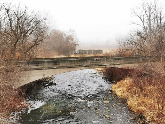
The concrete arch bridge at this location appears to be the old Romeo Plank bridge, which was most likely replaced by the current Romeo Plank Bridge, a 1964 bridge. This style of concrete arch bridge was once common in Macomb County, but through attrition, all but this and Chapman Road appear to remain. This Romeo Plank arch bridge is a one lane bridge, with intact guardrails. These railings are concrete, and have rectangles inscribed in them. There is evidence of plaques having once been on the bridge, but both have been removed. Compared to Chapman Road, this is a very large bridge. Since this bridge is similar to the Chapman Road Bridge as well as other demolished bridges in the county, it is assumed that this bridge was built circa 1910 likely by the Illinois Bridge Company of Chicago, Illinois. This company was one of a number of bridge companies authorized to build Luten patent bridges, and this bridge may well be built to the Luten patent. The railing panels are very similar to those found on other bridges associated with Luten.
The old alignment of the road can still be seen running to this bridge, as some of the asphalt still remains. The bridge appears to have been given to the nearby landowners, since it is fenced off now and does not appear to be public. This is a bridge that deserves to be preserved. It is among the least altered concrete arch bridges in Michigan and overall is still in decent condition. Its span length is fairly substantial as well.
The bridge still appears to be in good condition. A very long piece of reinforcing rod hangs in the river, which makes it look bad, but a closer inspection revealed that a piece of concrete that ran along the guardrails has fallen away on one side. Its something that would be repaired during a rehabilitation, but the bridge is not structurally compromised at this time. The other side (east side) is not like this at all and is in better condition. Some of the arch is cracked slightly, which would need to be patched if this bridge were restored. Similar repairs were made to the Chapman Road Bridge some time ago. Since this bridge is closed, and is not being cared for, these minor problems will slowly worsen and become major problems. If the concrete arch continues to crack and spall, the chances of it standing will decrease, and the cost to rehabilitate it will increase.
This bridge is tagged with the following special condition(s): Luten and Unorganized Photos
![]()
![]()
![]()
![]()
![]()
Coordinates (Latitude, Longitude):
Search For Additional Bridge Listings:
Bridgehunter.com: View listed bridges within 0.5 miles (0.8 kilometers) of this bridge.
Bridgehunter.com: View listed bridges within 10 miles (16 kilometers) of this bridge.
Additional Maps:
Google Streetview (If Available)
GeoHack (Additional Links and Coordinates)
Apple Maps (Via DuckDuckGo Search)
Apple Maps (Apple devices only)
Android: Open Location In Your Map or GPS App
Flickr Gallery (Find Nearby Photos)
Wikimedia Commons (Find Nearby Photos)
Directions Via Sygic For Android
Directions Via Sygic For iOS and Android Dolphin Browser
USGS National Map (United States Only)
Historical USGS Topo Maps (United States Only)
Historic Aerials (United States Only)
CalTopo Maps (United States Only)

© Copyright 2003-2024, HistoricBridges.org. All Rights Reserved. Disclaimer: HistoricBridges.org is a volunteer group of private citizens. HistoricBridges.org is NOT a government agency, does not represent or work with any governmental agencies, nor is it in any way associated with any government agency or any non-profit organization. While we strive for accuracy in our factual content, HistoricBridges.org offers no guarantee of accuracy. Information is provided "as is" without warranty of any kind, either expressed or implied. Information could include technical inaccuracies or errors of omission. Opinions and commentary are the opinions of the respective HistoricBridges.org member who made them and do not necessarily represent the views of anyone else, including any outside photographers whose images may appear on the page in which the commentary appears. HistoricBridges.org does not bear any responsibility for any consequences resulting from the use of this or any other HistoricBridges.org information. Owners and users of bridges have the responsibility of correctly following all applicable laws, rules, and regulations, regardless of any HistoricBridges.org information.
![]()