
View Information About HSR Ratings
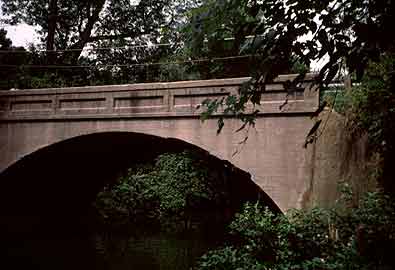
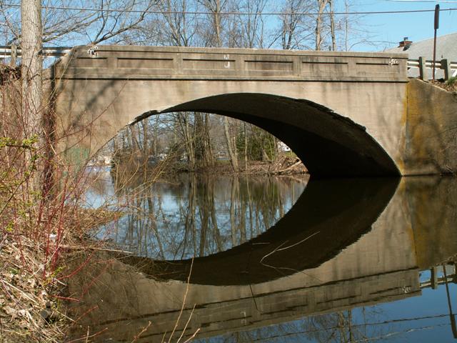
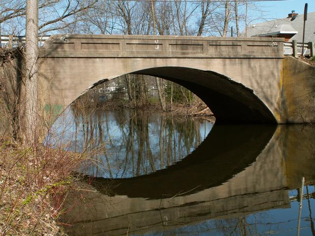
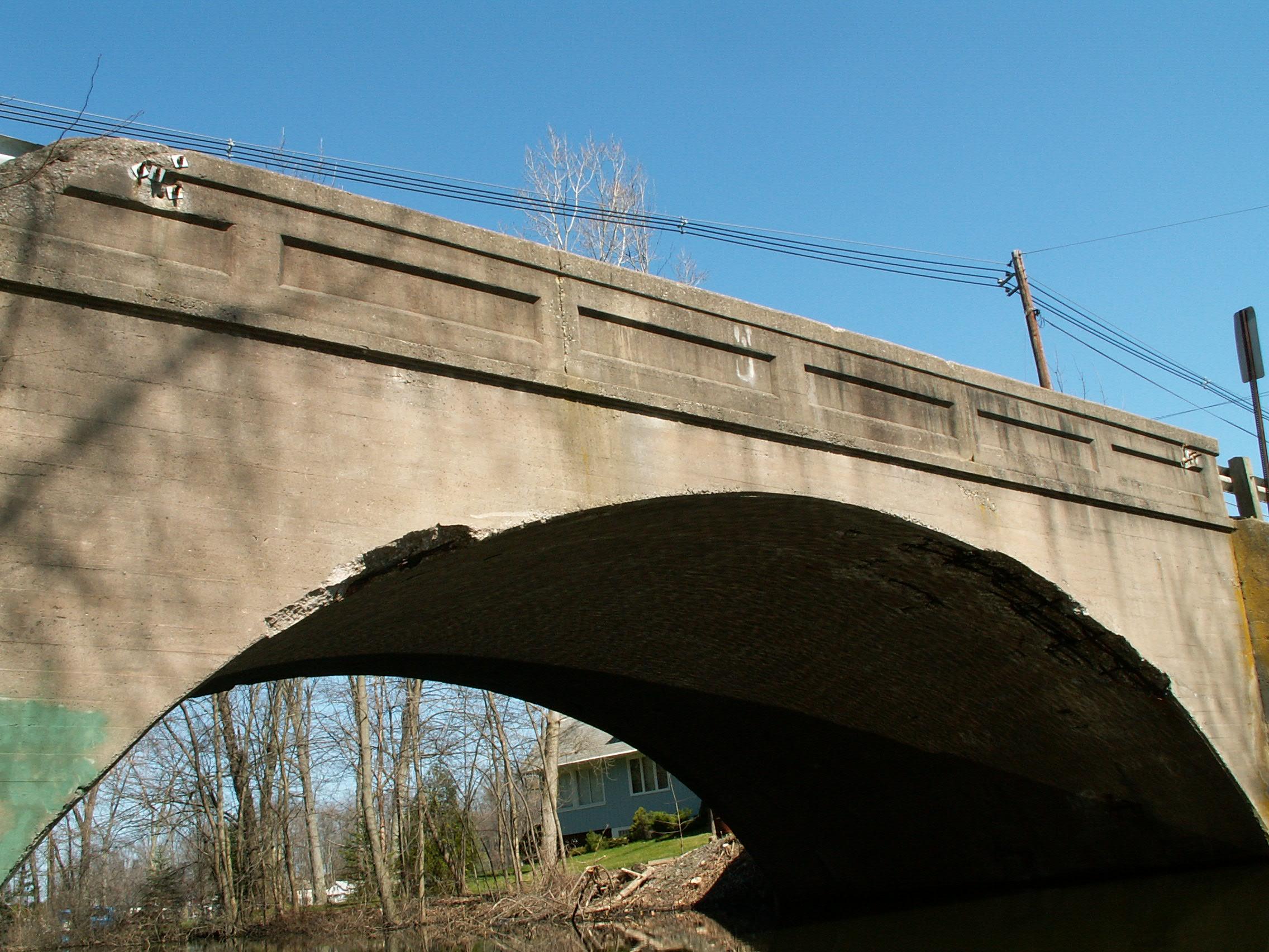
This is a very picturesque concrete arch bridge located next to Paw Paw Lake. This small outlet connects Paw Paw Lake to Paw Paw River, which winds around the lake.
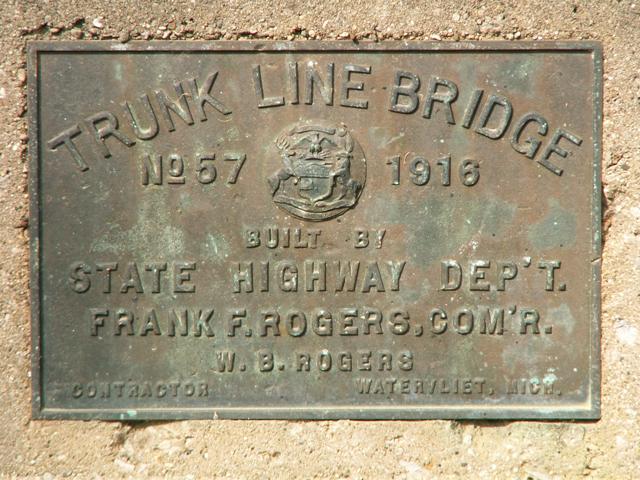
This is a very early trunk line bridge, only the 57th ever built by the State Highway Department. A local contractor from Watervliet, W. B. Rogers constructed the standard plan bridge in 1916. It no longer carries a trunk line; M-140 is currently aligned a bit to the East. As a result, this road is relatively quiet. It was not always so however. From 1918, the trunk line route was known as M-11. In 1926 route became US-31 until 1931 when US-31 was moved west to be a lakeshore route. At that point M-140 was placed on the road and bridge. Around 1959 the route was realigned to its current location. The bridge is in good condition, with only very minor railing and arch deterioration. One guardrail end appears to be broken off, possible from a collision before modern Armco guardrails were added to the approach. The bridge is posted with a 22-40-46 ton weight limit.
An interesting phenomenon is that this bridge, Trunk Line Bridge 57, survives, along with the very next trunk line bridge built, Trunk Line Bridge #58 also survives. It is also an arch bridge, but is located in the city of Wyoming and is the BL-196 Bridge.
Berrien County, which is not noted for historic bridge preservation, has decided to demolish this bridge. Other solutions, such as a repair project, and reduced speed limits on this residential road, would have been a better path to providing an efficient roadway system, while also retaining a structure with significant historic value and beauty.
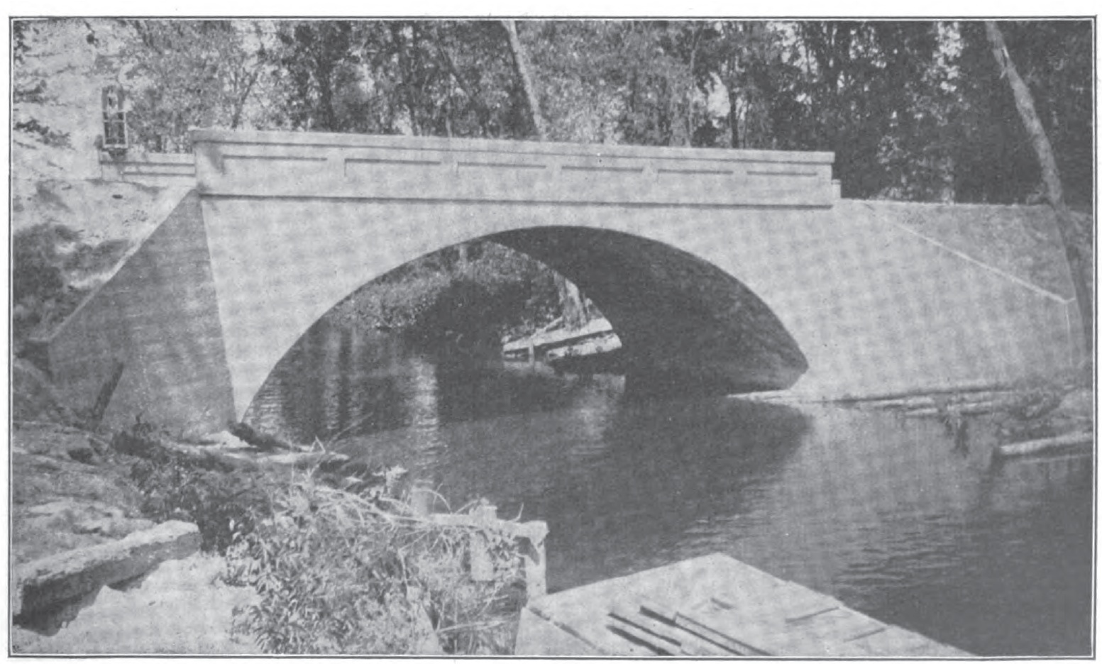
Below is a photo of the bridge in 1917 as it appeared in an issue of Michigan Roads and Forests.
Information and Findings From Michigan Historic Bridge Inventory
Narrative Description The bridge is eligible for the National Register as a well-preserved, early example of a concrete arch bridge built according to a state highway department standard plan. The bridge plates indicate that this structure was originally Trunk Line Bridge No. 57, built in 1916 by the state highway department. Although plans for the structure do not appear to survive, the design is based on a standard plan. The structure resembles the department's standard plan for a reinforced concrete arch published in the Fifth Biennial Report (1913-1914). It is very similar to a 31-foot span in Hillsdale County, Trunk Line Bridge No. 237, which is also eligible for the National Register. Contractor W. B. Rogers received $5,269 for erecting the North Watervliet Road Bridge. A photograph of the completed structure appeared in the state highway's department's sixth biennial report, published in 1916. The North Watervliet Road Bridge carried the West Michigan Pike, which paralleled the eastern shore of Lake Michigan from the Indiana border to the straits of Mackinac. Although this route helped promote tourism in western Michigan, archival research did not provide enough information to directly link the construction of the bridge with the tourism industry. Information and Findings From Michigan Historic Sites OnlineNarrative Description main span number: 1 main span length: 40.0 structure length: 45.0 roadway width: 22.0 structure width: 24.0 The North Watervliet Road Bridge is located slightly north of the city limits of Watervliet and just east of Paw Paw Lake in a rural residential area. The road curves sharply to the south of the bridge. The bridge appears to serve residents and people visiting Paw Paw Lake. The bridge features solid concrete parapet railings with six recesses on each side, and Armco guard rails bolted to corners. Identical bridge plates appear at the north and south corners. The bridge's arch is barrel vaulted. Statement of Significance The bridge plates indicate that this structure was originally Trunk Line No. 57, built in 1916 by the state highway department, presumable according to a standard plan. The structure resembles the department's standard plan for a reinforced concrete arch found in the Fifth Biennial Report (1913-1914). The route was part of the West Michigan Pike, which promoted tourism in the western half of the state. This bridge is eligible for the National Register under Criterion C, as a good, early example of a concrete arch bridge built according to a state highway department standard plan. |
![]()
![]()
![]()
![]()
This historic bridge has been demolished. This map is shown for reference purposes only.
Coordinates (Latitude, Longitude):
Search For Additional Bridge Listings:
Bridgehunter.com: View listed bridges within 0.5 miles (0.8 kilometers) of this bridge.
Bridgehunter.com: View listed bridges within 10 miles (16 kilometers) of this bridge.
Additional Maps:
Google Streetview (If Available)
GeoHack (Additional Links and Coordinates)
Apple Maps (Via DuckDuckGo Search)
Apple Maps (Apple devices only)
Android: Open Location In Your Map or GPS App
Flickr Gallery (Find Nearby Photos)
Wikimedia Commons (Find Nearby Photos)
Directions Via Sygic For Android
Directions Via Sygic For iOS and Android Dolphin Browser
USGS National Map (United States Only)
Historical USGS Topo Maps (United States Only)
Historic Aerials (United States Only)
CalTopo Maps (United States Only)

© Copyright 2003-2024, HistoricBridges.org. All Rights Reserved. Disclaimer: HistoricBridges.org is a volunteer group of private citizens. HistoricBridges.org is NOT a government agency, does not represent or work with any governmental agencies, nor is it in any way associated with any government agency or any non-profit organization. While we strive for accuracy in our factual content, HistoricBridges.org offers no guarantee of accuracy. Information is provided "as is" without warranty of any kind, either expressed or implied. Information could include technical inaccuracies or errors of omission. Opinions and commentary are the opinions of the respective HistoricBridges.org member who made them and do not necessarily represent the views of anyone else, including any outside photographers whose images may appear on the page in which the commentary appears. HistoricBridges.org does not bear any responsibility for any consequences resulting from the use of this or any other HistoricBridges.org information. Owners and users of bridges have the responsibility of correctly following all applicable laws, rules, and regulations, regardless of any HistoricBridges.org information.
![]()