

View Information About HSR Ratings
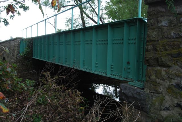
This bridge is an interesting combination of a plate girder bridge with tiny stone arch culvert approaches. The bridge is also noteworthy because it was rehabilitated (between 2008 and 2011), rather than demolished and replaced as has been the trend in Pennsylvania thus far into the 21st Century. A number of alterations took place during this rehabilitation, however the overall structure retains its original appearance. A number of non-original bolts were added to the sides of the girders. The pole railings appear to have been replaced. Also, the original girder plaque was replaced with a replica. A non-original steel grate deck was replaced with a concrete deck. An earlier rehabilitation took place in 1971 is when the metal grate deck had been installed.
Information and Findings From Pennsylvania's Historic Bridge InventoryDiscussion of Bridge The 3 span, 55'-long bridge built in 1910 consists of an approximately 43'-long steel thru girder span flanked by 6'-long stone arch overflow spans. The bridge is supported on a stone substructure. Fieldstone wingwalls with parapets enclose the approach roadways. Incorporated with the wingwalls are the short stone arch overflow spans. In 1971, the thru girder span was altered by the addition of welded rolled floorbeams spaced between the original riveted rolled floorbeams. At the same time, the previous concrete deck was replaced by an open steel grid deck. Thru girder bridges are a very common bridge type in widespread use from the late 19th century through the mid 20th century. This altered example has no technologically unusual or noteworthy features, and incorporates details, such as the stone arch overflow spans and wingwalls, that are very typical of bridges designed by Chester County Engineer Nathan R. Rambo from 1899 to 1922. The bridge is not significant in the state context, and more complete prototypical examples have been chosen to represent the bridge type's significance in the county context. The bridge is not historically significant in association with its setting. Discussion of Surrounding Area The bridge carries a 2 lane road over a stream in a rural setting of active farms and mixed 19th to late-20th-century residences approximately 1/2 mile east of the crossroads village of Cambridge. The setting does not have the cohesiveness or integrity of a potential historic district, although there are some individual properties with possible individual historic significance including a mid 19th century stone mill building (inoperable) at the bridge's northwest quadrant. The other bridge quadrants are wooded or open fields. Bridge Considered Historic By Survey: No |
![]()
![]()
![]()
Coordinates (Latitude, Longitude):
Search For Additional Bridge Listings:
Bridgehunter.com: View listed bridges within 0.5 miles (0.8 kilometers) of this bridge.
Bridgehunter.com: View listed bridges within 10 miles (16 kilometers) of this bridge.
Additional Maps:
Google Streetview (If Available)
GeoHack (Additional Links and Coordinates)
Apple Maps (Via DuckDuckGo Search)
Apple Maps (Apple devices only)
Android: Open Location In Your Map or GPS App
Flickr Gallery (Find Nearby Photos)
Wikimedia Commons (Find Nearby Photos)
Directions Via Sygic For Android
Directions Via Sygic For iOS and Android Dolphin Browser
USGS National Map (United States Only)
Historical USGS Topo Maps (United States Only)
Historic Aerials (United States Only)
CalTopo Maps (United States Only)

© Copyright 2003-2024, HistoricBridges.org. All Rights Reserved. Disclaimer: HistoricBridges.org is a volunteer group of private citizens. HistoricBridges.org is NOT a government agency, does not represent or work with any governmental agencies, nor is it in any way associated with any government agency or any non-profit organization. While we strive for accuracy in our factual content, HistoricBridges.org offers no guarantee of accuracy. Information is provided "as is" without warranty of any kind, either expressed or implied. Information could include technical inaccuracies or errors of omission. Opinions and commentary are the opinions of the respective HistoricBridges.org member who made them and do not necessarily represent the views of anyone else, including any outside photographers whose images may appear on the page in which the commentary appears. HistoricBridges.org does not bear any responsibility for any consequences resulting from the use of this or any other HistoricBridges.org information. Owners and users of bridges have the responsibility of correctly following all applicable laws, rules, and regulations, regardless of any HistoricBridges.org information.
![]()