

View Information About HSR Ratings
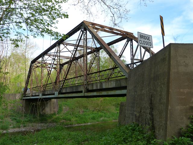
This bridge is a riveted Pratt truss. It has some lattice railings that have a different appearance because of an extra horizontal angle running through the middle of the railing. The bridge has been closed to traffic. However, the bridge is not deteriorated in a way that would make rehabilitation for continued light vehicular use difficult. HistoricBridges.org recommends that the bridge be rehabilitated for continued vehicular use. A target weight limit of 10 tons would allow the vast majority of vehicles to use this quiet rural road. Rehabilitation for this purpose would likely cost less than a demolition and replacement project.
Information and Findings From Pennsylvania's Historic Bridge InventoryDiscussion of Bridge The single-span, 95'-long, riveted Pratt thru truss bridge built in 1916 is supported on concrete abutments with wingwalls. The trusses are traditionally composed, and the bridge has no innovative or distinctive details. Although it appears to be complete, it is a late example of its type and design. Neither the bridge nor its setting are historically or technologically significant. It is located in a county with over 35 metal truss bridges. Discussion of Surrounding Area The bridge carries one lane of a two-lane road over a stream in a sparsely developed, wooded setting with scattered houses and modular housing. Bridge Considered Historic By Survey: No |
![]()
![]()
![]()
This historic bridge has been demolished. This map is shown for reference purposes only.
Coordinates (Latitude, Longitude):
Search For Additional Bridge Listings:
Bridgehunter.com: View listed bridges within 0.5 miles (0.8 kilometers) of this bridge.
Bridgehunter.com: View listed bridges within 10 miles (16 kilometers) of this bridge.
Additional Maps:
Google Streetview (If Available)
GeoHack (Additional Links and Coordinates)
Apple Maps (Via DuckDuckGo Search)
Apple Maps (Apple devices only)
Android: Open Location In Your Map or GPS App
Flickr Gallery (Find Nearby Photos)
Wikimedia Commons (Find Nearby Photos)
Directions Via Sygic For Android
Directions Via Sygic For iOS and Android Dolphin Browser
USGS National Map (United States Only)
Historical USGS Topo Maps (United States Only)
Historic Aerials (United States Only)
CalTopo Maps (United States Only)

© Copyright 2003-2024, HistoricBridges.org. All Rights Reserved. Disclaimer: HistoricBridges.org is a volunteer group of private citizens. HistoricBridges.org is NOT a government agency, does not represent or work with any governmental agencies, nor is it in any way associated with any government agency or any non-profit organization. While we strive for accuracy in our factual content, HistoricBridges.org offers no guarantee of accuracy. Information is provided "as is" without warranty of any kind, either expressed or implied. Information could include technical inaccuracies or errors of omission. Opinions and commentary are the opinions of the respective HistoricBridges.org member who made them and do not necessarily represent the views of anyone else, including any outside photographers whose images may appear on the page in which the commentary appears. HistoricBridges.org does not bear any responsibility for any consequences resulting from the use of this or any other HistoricBridges.org information. Owners and users of bridges have the responsibility of correctly following all applicable laws, rules, and regulations, regardless of any HistoricBridges.org information.
![]()