

View Information About HSR Ratings
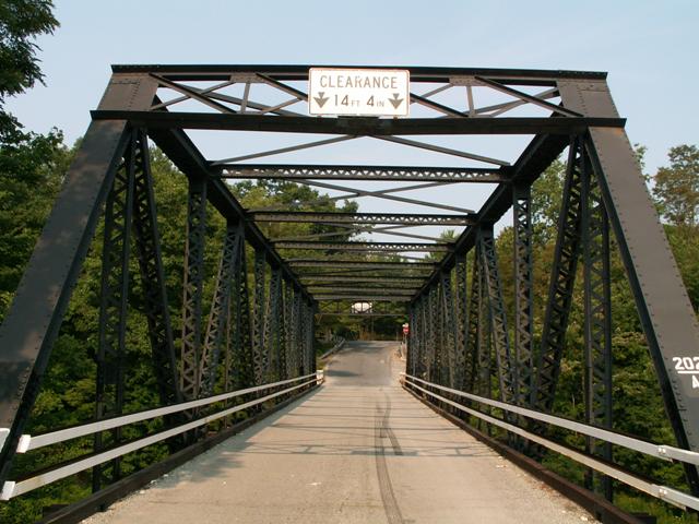
This bridge is an attractive, traditional example of a riveted Warren through truss. It has received some alterations, and modern bolts are visible on portions of the bridge. Otherwise, historic integrity is good. However, structural integrity is apparently not so good. This bridge had a very low 2% sufficiency rating in 2006, and the bridge is on a state-owned route. However, the bridge is listed as being maintained by the railroad. Regardless of who owns the bridge, PennDOT will likely do what it normally does and see the bridge demolished, whether by their hand or the railroad's. On-site conditions and time did not allow for an inspection under the bridge's deck, which is apparently where the problems are, because the trusses as seen from the road appear to be in decent shape.
Information and Findings From Pennsylvania's Historic Bridge InventoryDiscussion of Bridge The single span, 148'-long and 19' wide, 6 panel, riveted Warren thru truss with verticals bridge is supported on concrete abutments. The trusses are traditionally composed, and repairs to the lower chords have been done with in kind material bolted to the original fabric. An example of common period technology, the bridge is not individually significant, and the rail line that it crosses is not historically significant. Neither the bridge nor its setting are historically or technologically significant. Discussion of Surrounding Area The bridge carries a 2 lane road over CSXT railroad tracks in a rural area of active farms. A third track has been removed. The line is the B&O RR's former Somerset & Cambria RR, a branch line connecting Johnstown with the B&O's Pennsylvania main line. The branch line is not historically significant. Bridge Considered Historic By Survey: No |
![]()
![]()
This historic bridge has been demolished. This map is shown for reference purposes only.
Coordinates (Latitude, Longitude):
Search For Additional Bridge Listings:
Bridgehunter.com: View listed bridges within 0.5 miles (0.8 kilometers) of this bridge.
Bridgehunter.com: View listed bridges within 10 miles (16 kilometers) of this bridge.
Additional Maps:
Google Streetview (If Available)
GeoHack (Additional Links and Coordinates)
Apple Maps (Via DuckDuckGo Search)
Apple Maps (Apple devices only)
Android: Open Location In Your Map or GPS App
Flickr Gallery (Find Nearby Photos)
Wikimedia Commons (Find Nearby Photos)
Directions Via Sygic For Android
Directions Via Sygic For iOS and Android Dolphin Browser
USGS National Map (United States Only)
Historical USGS Topo Maps (United States Only)
Historic Aerials (United States Only)
CalTopo Maps (United States Only)

© Copyright 2003-2024, HistoricBridges.org. All Rights Reserved. Disclaimer: HistoricBridges.org is a volunteer group of private citizens. HistoricBridges.org is NOT a government agency, does not represent or work with any governmental agencies, nor is it in any way associated with any government agency or any non-profit organization. While we strive for accuracy in our factual content, HistoricBridges.org offers no guarantee of accuracy. Information is provided "as is" without warranty of any kind, either expressed or implied. Information could include technical inaccuracies or errors of omission. Opinions and commentary are the opinions of the respective HistoricBridges.org member who made them and do not necessarily represent the views of anyone else, including any outside photographers whose images may appear on the page in which the commentary appears. HistoricBridges.org does not bear any responsibility for any consequences resulting from the use of this or any other HistoricBridges.org information. Owners and users of bridges have the responsibility of correctly following all applicable laws, rules, and regulations, regardless of any HistoricBridges.org information.
![]()