

View Information About HSR Ratings
This bridge is one of several surviving plate girder highway bridges in Chester County. A number of these bridges, including this one, stand out for their use of handsome stone abutments, an interesting contrast to the simple riveted plate girder superstructure. This bridge does not display any remarkable features among the surviving plate girder bridges in the county, but it is unaltered and in good condition.
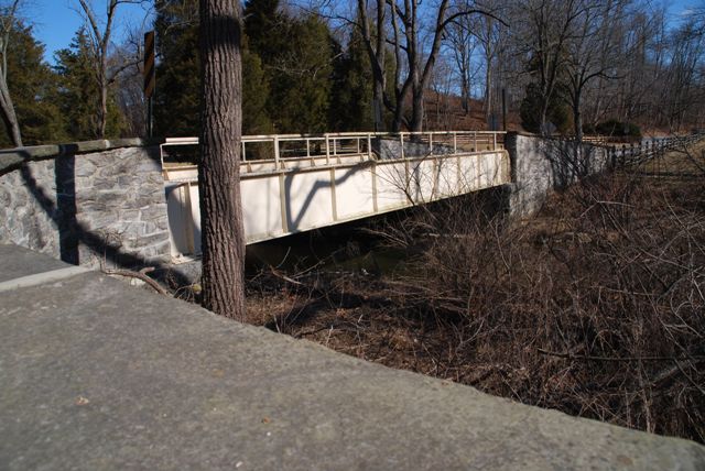
Information and Findings From Pennsylvania's Historic Bridge InventoryDiscussion of Bridge The one-span, 48'-long, steel thru girder bridge is supported on stone abutments. Built-up girders support rolled floorbeams and a concrete slab deck. One-high rail pipe hand railings are bolted to the top flange of the built-up girders. Fieldstone wingwalls with parapets enclose the approach roadways. According to county records, the bridge is a standard steel thru girder bridge built by the county as a routine bridge replacement project. It is a historically and technologically undistinguished example of a very common bridge type. It has no unusual or individually significant features. It is not located adjacent to the NReligible Runnymeade Farm complex. Based on the bridge's 20th-century date of construction and history as a replacement structure on a preexisting road, the bridge does not have a significant historic association with the farm, which is significant for its 18th- and 19th-century buildings and association with pre-1900 agricultural land uses and settlement patterns. Discussion of Surrounding Area The bridge carries a 2 lane road over a stream in a rural setting of active farms and scattered late-20th-century residences. Fields are to each of the bridge's quadrants. At the northwest corner is an iron gate and farm lane to the Runnymeade Farm. The 18th- and 19th-century farm complex has been determined eligible by PHMC (1/9/1985). Bridge Considered Historic By Survey: No |
![]()
![]()
![]()
Coordinates (Latitude, Longitude):
Search For Additional Bridge Listings:
Bridgehunter.com: View listed bridges within 0.5 miles (0.8 kilometers) of this bridge.
Bridgehunter.com: View listed bridges within 10 miles (16 kilometers) of this bridge.
Additional Maps:
Google Streetview (If Available)
GeoHack (Additional Links and Coordinates)
Apple Maps (Via DuckDuckGo Search)
Apple Maps (Apple devices only)
Android: Open Location In Your Map or GPS App
Flickr Gallery (Find Nearby Photos)
Wikimedia Commons (Find Nearby Photos)
Directions Via Sygic For Android
Directions Via Sygic For iOS and Android Dolphin Browser
USGS National Map (United States Only)
Historical USGS Topo Maps (United States Only)
Historic Aerials (United States Only)
CalTopo Maps (United States Only)

© Copyright 2003-2024, HistoricBridges.org. All Rights Reserved. Disclaimer: HistoricBridges.org is a volunteer group of private citizens. HistoricBridges.org is NOT a government agency, does not represent or work with any governmental agencies, nor is it in any way associated with any government agency or any non-profit organization. While we strive for accuracy in our factual content, HistoricBridges.org offers no guarantee of accuracy. Information is provided "as is" without warranty of any kind, either expressed or implied. Information could include technical inaccuracies or errors of omission. Opinions and commentary are the opinions of the respective HistoricBridges.org member who made them and do not necessarily represent the views of anyone else, including any outside photographers whose images may appear on the page in which the commentary appears. HistoricBridges.org does not bear any responsibility for any consequences resulting from the use of this or any other HistoricBridges.org information. Owners and users of bridges have the responsibility of correctly following all applicable laws, rules, and regulations, regardless of any HistoricBridges.org information.
![]()