

View Information About HSR Ratings
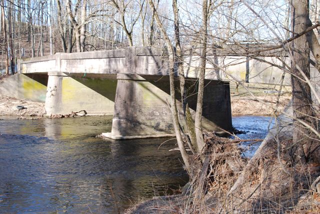
This bridge is a rare example of a multi-span concrete through girder. It is especially rare in Chester County, which did not build many bridges of this type. The claim by the Historic Bridge Inventory that 65 examples of this bridge type remain in Pennsylvania is outdated.
Information and Findings From Pennsylvania's Historic Bridge InventoryDiscussion of Bridge The 3-span, 136'-long, reinforced concrete thru girder bridge built in 1926 is supported on concrete piers and abutments. The unadorned girders serve as the bridge's parapets and support an integral slab deck. The reinforced concrete thru girder bridge type and design was developed during the first decade of the 20th century, but never proved as successful as other reinforced concrete bridge types such as slabs and T beams. Reinforced concrete thru girder bridges were popular with some county engineers for short periods of time, but they were never widely used or favored by Chester County engineers. It is not a historically important bridge type in the Chester County context. Over 65 examples from 1906 to the late 1920s have been identified in the state. This 1926 example is a later example of the technology and it has no noteworthy features. It is not historically distinguished by its technology, setting or context. Discussion of Surrounding Area The bridge carries a 2 lane road over a stream in a forested setting. The setting does not appear to have historic district potential. Bridge Considered Historic By Survey: No |
![]()
![]()
![]()
Coordinates (Latitude, Longitude):
Search For Additional Bridge Listings:
Bridgehunter.com: View listed bridges within 0.5 miles (0.8 kilometers) of this bridge.
Bridgehunter.com: View listed bridges within 10 miles (16 kilometers) of this bridge.
Additional Maps:
Google Streetview (If Available)
GeoHack (Additional Links and Coordinates)
Apple Maps (Via DuckDuckGo Search)
Apple Maps (Apple devices only)
Android: Open Location In Your Map or GPS App
Flickr Gallery (Find Nearby Photos)
Wikimedia Commons (Find Nearby Photos)
Directions Via Sygic For Android
Directions Via Sygic For iOS and Android Dolphin Browser
USGS National Map (United States Only)
Historical USGS Topo Maps (United States Only)
Historic Aerials (United States Only)
CalTopo Maps (United States Only)

© Copyright 2003-2024, HistoricBridges.org. All Rights Reserved. Disclaimer: HistoricBridges.org is a volunteer group of private citizens. HistoricBridges.org is NOT a government agency, does not represent or work with any governmental agencies, nor is it in any way associated with any government agency or any non-profit organization. While we strive for accuracy in our factual content, HistoricBridges.org offers no guarantee of accuracy. Information is provided "as is" without warranty of any kind, either expressed or implied. Information could include technical inaccuracies or errors of omission. Opinions and commentary are the opinions of the respective HistoricBridges.org member who made them and do not necessarily represent the views of anyone else, including any outside photographers whose images may appear on the page in which the commentary appears. HistoricBridges.org does not bear any responsibility for any consequences resulting from the use of this or any other HistoricBridges.org information. Owners and users of bridges have the responsibility of correctly following all applicable laws, rules, and regulations, regardless of any HistoricBridges.org information.
![]()