

View Information About HSR Ratings
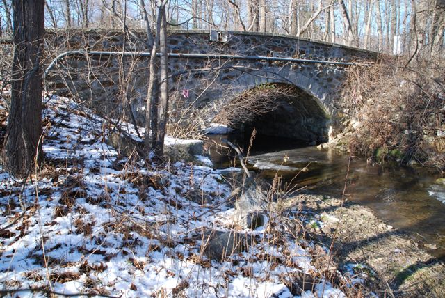
This bridge is a small single span stone arch bridge that appears to be in good condition.
Information and Findings From Pennsylvania's Historic Bridge InventoryDiscussion of Bridge The one-span, 22'-long, stone arch bridge has voussoirs, fieldstone spandrel walls and parapets with replacement concrete coping. The intrados has been pargetted. It is an example of a bridge type that is common from the first two decades of the 20th century in Chester County. The traditional stone arch bridges were favored by the county engineer, and at least 19 similar bridges from 1908 to 1919 have been identified. Stone arch bridges have been in use in Pennsylvania since the late 17th century, and over 350 examples have been identified statewide, with more than two-thirds dating to before 1900. Early 20th century examples in Chester County are considered individually significant in the local context only when they are complete and large or particularly well detailed. This example is not historically or technologically distinguished within its population or by its setting and context. It postdates the adjacent Rose Cottage, a remodeled ca. 1820-60 school building, and does not have a significant historic association with the development of the school or the Isabella Iron Furnace, which closed by the 1890s. Discussion of Surrounding Area The bridge carries a 2 lane road over a stream in a rural setting. Three of the bridge's four quadrants are wooded. At the southwest quadrant is a one-story stone building with two sections connected by a hyphen. After laying vacant for many years, it has been recently remodeled as a residence (ca. 1985) with replacement windows, doors and an addition. According to PHMC survey files, the building was the Rose Cottage, a school started by the wife of a local ironmaster ca. 1820-60. The school building does not have integrity of original design. The Isabella Iron Furnace, which operated until the 1890s, is in ruins and located more than 1/2 mile to the north. Bridge Considered Historic By Survey: No Information and Findings From Pennsylvania's Stone Arch Bridge Management PlanDiscussion of Bridge This bridge is not recommended for long-term preservation. It ranks in the lowest third of all stone arch bridges under study in this plan. Its condition code is moderate, a result of some scour and some cracks. Its transportation code is moderate, bordering on low, a result of high traffic volumes and a relatively narrow roadway width. The bridge stands in an area of moderate potential for development, and may have difficulty handling even a minor increase in traffic; this will exacerbate its already inadequate transportation code. Its waterway is adequate. The bridge is not listed in or eligible for listing in the National Register of Historic Places individually or as part of a historic district, and it is not in a park, natural area, or greenway, resulting in a very low values code. The public input code is also very low; the bridge has not received any public support. Ratings The West Nantmeal, Creek Road Bridge is owned by
PennDOT and is ranked 90th. Recommendation: Not recommended for long-term preservation. |
![]()
![]()
![]()
Coordinates (Latitude, Longitude):
Search For Additional Bridge Listings:
Bridgehunter.com: View listed bridges within 0.5 miles (0.8 kilometers) of this bridge.
Bridgehunter.com: View listed bridges within 10 miles (16 kilometers) of this bridge.
Additional Maps:
Google Streetview (If Available)
GeoHack (Additional Links and Coordinates)
Apple Maps (Via DuckDuckGo Search)
Apple Maps (Apple devices only)
Android: Open Location In Your Map or GPS App
Flickr Gallery (Find Nearby Photos)
Wikimedia Commons (Find Nearby Photos)
Directions Via Sygic For Android
Directions Via Sygic For iOS and Android Dolphin Browser
USGS National Map (United States Only)
Historical USGS Topo Maps (United States Only)
Historic Aerials (United States Only)
CalTopo Maps (United States Only)

© Copyright 2003-2024, HistoricBridges.org. All Rights Reserved. Disclaimer: HistoricBridges.org is a volunteer group of private citizens. HistoricBridges.org is NOT a government agency, does not represent or work with any governmental agencies, nor is it in any way associated with any government agency or any non-profit organization. While we strive for accuracy in our factual content, HistoricBridges.org offers no guarantee of accuracy. Information is provided "as is" without warranty of any kind, either expressed or implied. Information could include technical inaccuracies or errors of omission. Opinions and commentary are the opinions of the respective HistoricBridges.org member who made them and do not necessarily represent the views of anyone else, including any outside photographers whose images may appear on the page in which the commentary appears. HistoricBridges.org does not bear any responsibility for any consequences resulting from the use of this or any other HistoricBridges.org information. Owners and users of bridges have the responsibility of correctly following all applicable laws, rules, and regulations, regardless of any HistoricBridges.org information.
![]()