

View Information About HSR Ratings
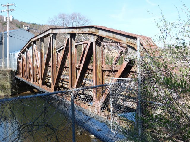
This bridge is an example of a pony truss in Pennsylvania built to a state standard plan. The bridge is closed to traffic and completely fenced off. It appears to have led into an area which is now completely private property. The bridge no longer appears on the National Bridge Inventory, and so the bridge itself may be privately owned. Although the Historic Bridge Inventory quickly dismissed the bridge as not noteworthy, HistoricBridges.org observes that this bridge exhibits one of the longest pony truss spans in the state. Most state standard plan truss bridges of this design in Pennsylvania appear to be between 90 and 120 feet long. With a 125 foot span, this bridge stands out as a significant example of state standard truss bridge construction.
Information and Findings From Pennsylvania's Historic Bridge InventoryDiscussion of Bridge The skewed, single span, 125'-long, rivet-connected Parker pony truss bridge is supported on concrete pargetted stone abutments with ashlar wingwalls. The top and bottom chords are built-up members, and the verticals and diagonals are rolled I beam sections. The bridge is an example of a state highway department standard design that was used with great frequency beginning in the mid 1920s. It has no innovative or distinctive details. More than 90 Parker truss bridges built after 1925 remain statewide. The bridge is not historically or technologically distinguished by its setting or context. Discussion of Surrounding Area The bridge carries a single lane of traffic and a sidewalk over a stream in a modern industrial setting adjacent to a paper mill on the outskirts of Johnsonburg borough. The mill is dominated by late-20th-century processing buildings. The setting does not have historic district potential. The bridge is not within the boundaries of the potential downtown Johnsonburg Historic District identified by PHMC (DOE 4/2/1998). Bridge Considered Historic By Survey: No |
![]()
![]()
![]()
Coordinates (Latitude, Longitude):
Search For Additional Bridge Listings:
Bridgehunter.com: View listed bridges within 0.5 miles (0.8 kilometers) of this bridge.
Bridgehunter.com: View listed bridges within 10 miles (16 kilometers) of this bridge.
Additional Maps:
Google Streetview (If Available)
GeoHack (Additional Links and Coordinates)
Apple Maps (Via DuckDuckGo Search)
Apple Maps (Apple devices only)
Android: Open Location In Your Map or GPS App
Flickr Gallery (Find Nearby Photos)
Wikimedia Commons (Find Nearby Photos)
Directions Via Sygic For Android
Directions Via Sygic For iOS and Android Dolphin Browser
USGS National Map (United States Only)
Historical USGS Topo Maps (United States Only)
Historic Aerials (United States Only)
CalTopo Maps (United States Only)

© Copyright 2003-2024, HistoricBridges.org. All Rights Reserved. Disclaimer: HistoricBridges.org is a volunteer group of private citizens. HistoricBridges.org is NOT a government agency, does not represent or work with any governmental agencies, nor is it in any way associated with any government agency or any non-profit organization. While we strive for accuracy in our factual content, HistoricBridges.org offers no guarantee of accuracy. Information is provided "as is" without warranty of any kind, either expressed or implied. Information could include technical inaccuracies or errors of omission. Opinions and commentary are the opinions of the respective HistoricBridges.org member who made them and do not necessarily represent the views of anyone else, including any outside photographers whose images may appear on the page in which the commentary appears. HistoricBridges.org does not bear any responsibility for any consequences resulting from the use of this or any other HistoricBridges.org information. Owners and users of bridges have the responsibility of correctly following all applicable laws, rules, and regulations, regardless of any HistoricBridges.org information.
![]()