

View Information About HSR Ratings
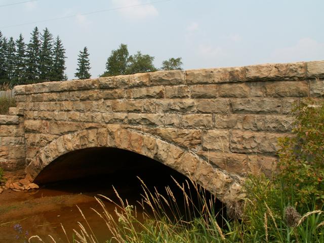
This bridge is an attractive stone arch bridge that might be considered an unexpected find, since it is located on a fairly well-traveled state highway that includes heavy truck traffic. The bridge may seem a bit wide for a 1905 bridge, but the truth is that it was not always this wide. The bridge was widened in 1935 with concrete. So today, half of the bridge is technically a concrete arch bridge. However, when the bridge was widened, the stones from that end of the bridge were set in front of the concrete, so the bridge continues to have the exact appearance it always did, only a bit wider.
The bridge is today an important example of stone arch technology in southwestern Pennsylvania, despite the 1935 alteration. The continued structural soundness of the stone arches showcase the excellent workmanship behind the bridge.
Information and Findings From Pennsylvania's Historic Bridge InventoryDiscussion of Bridge The 38'-long stone arch bridge was built ca. 1905 with a 19.5' width. It was extended by 11.5' by adding a reinforced concrete arch on the downstream side in 1935. The original spandrel wall and ring stones were carefully reused to finish the extension giving the bridge its original appearance on both elevations. The bridge is 1 of 7 similar handsome ashlar stone arch bridges in the county built between ca. 1905 and ca. 1915. It is technologically significant as one of the earliest, and it is historically significant as a contributing resource to a potential Brothers Valley rural historic district with a period of significance through 1947. Discussion of Surrounding Area The bridge carries a 2 lane road with shoulders over a stream in a pristine agricultural area in Brothers Valley. Beyond the bridge is a late-19th century farmstead with mid-20th century outbuildings. The bridge is located in, and contributes to the character of, a potential rural historic district with a period of significance through 1947. Bridge Considered Historic By Survey: Yes |
![]()
![]()
Coordinates (Latitude, Longitude):
Search For Additional Bridge Listings:
Bridgehunter.com: View listed bridges within 0.5 miles (0.8 kilometers) of this bridge.
Bridgehunter.com: View listed bridges within 10 miles (16 kilometers) of this bridge.
Additional Maps:
Google Streetview (If Available)
GeoHack (Additional Links and Coordinates)
Apple Maps (Via DuckDuckGo Search)
Apple Maps (Apple devices only)
Android: Open Location In Your Map or GPS App
Flickr Gallery (Find Nearby Photos)
Wikimedia Commons (Find Nearby Photos)
Directions Via Sygic For Android
Directions Via Sygic For iOS and Android Dolphin Browser
USGS National Map (United States Only)
Historical USGS Topo Maps (United States Only)
Historic Aerials (United States Only)
CalTopo Maps (United States Only)

© Copyright 2003-2024, HistoricBridges.org. All Rights Reserved. Disclaimer: HistoricBridges.org is a volunteer group of private citizens. HistoricBridges.org is NOT a government agency, does not represent or work with any governmental agencies, nor is it in any way associated with any government agency or any non-profit organization. While we strive for accuracy in our factual content, HistoricBridges.org offers no guarantee of accuracy. Information is provided "as is" without warranty of any kind, either expressed or implied. Information could include technical inaccuracies or errors of omission. Opinions and commentary are the opinions of the respective HistoricBridges.org member who made them and do not necessarily represent the views of anyone else, including any outside photographers whose images may appear on the page in which the commentary appears. HistoricBridges.org does not bear any responsibility for any consequences resulting from the use of this or any other HistoricBridges.org information. Owners and users of bridges have the responsibility of correctly following all applicable laws, rules, and regulations, regardless of any HistoricBridges.org information.
![]()