

View Information About HSR Ratings
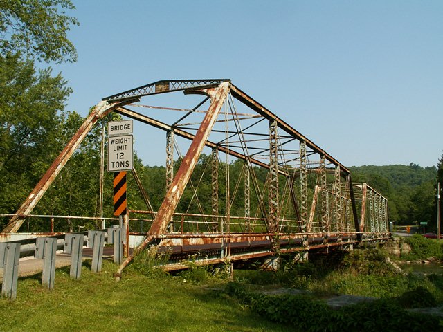
This bridge is located in the center of Oil Creek State Park, and it is worthy contender for the park's prime attraction, and most certainly is a fitting centerpiece to the park. The bridge is an extremely rare surviving example of a bridge built by the Morse Bridge Company, and one of the only known surviving multi-span example's of the company's work. Surviving through truss bridges built by the Morse Bridge Company are highly significant since the company was noted for varying its aesthetic treatment from bridge to bridge and so individual surviving bridges may be unique, the only one of their kind. This appears to be the case with the Petroleum Center Bridge as its triangular design, pedimented portal bracing is unlike any other known bridge by the company, with the only thing coming close being the decorative portal bracing seen on Six Mile Creek Road in Michigan, although that bracing has a curved design.
The Petroleum Center Bridge also displays some of the unusual construction details of older Morse Bridge Company bridges, notably the omission of any struts or sway bracing and the use of heavier angle for lateral bracing to compensate for this design. The bridge also has the unusual cast iron washers for the pins that the company was noted for. One unusual construction detail on this bridge not found on other Morse Bridge Company bridges is the v-lacing design on the verticals. The lacing bars do not have the standard rounded ends and also there are two rivets at the end of each bar instead of the usual single rivet. Furthermore, the lacing bars do not overlap and share rivers. These three noted design details of the v-lacing are not normally found on highway truss bridges, but is more common on railroad bridges.
It is also a wonderfully ornate structure, with Both the Six Mile Creek Road and the Eagle Rock Bridge were built by the Morse Bridge Company. The Eagle Rock Bridge is a particularly stunning example of the company's work since it is a two-span structure. The bridge features unusual "railroad style" v-lacing on the vertical members. I have not seen this v-lacing style, which features a separate rivet for each lacing piece, on many pin connected highway truss bridges. Restoration should be considered a priority for this bridge, although I am doubtful that it is.
Information and Findings From Pennsylvania's Historic Bridge InventoryDiscussion of Bridge The 1884, pin connected, 2 span, 239'-long (2 @ 115'), Pratt thru truss bridge is supported on an ashlar substructure. The portal is detailed with corner brackets with pierced decoration and a lattice-filled pedimented top brace. The original floorbeams were built up sections, but a number of them and their hangers were replaced with rolled I sections in 1984. There are limited repairs to the verticals. The steel channel railings inside the truss lines were placed in 1947 as was the open grid steel deck. The bridge is historically and technologically significant as an early and fairly complete example of the important bridge type and as an example of the work of the Morse Bridge Company of Youngstown, OH. Discussion of Surrounding Area The bridge carries 1 lane of a road over a stream in Oil Creek State Park. The wooded setting with scattered, undistinguished 20th century residences does not have historic district potential. Bridge Considered Historic By Survey: Yes |
![]()
![]()
![]()
Coordinates (Latitude, Longitude):
Search For Additional Bridge Listings:
Bridgehunter.com: View listed bridges within 0.5 miles (0.8 kilometers) of this bridge.
Bridgehunter.com: View listed bridges within 10 miles (16 kilometers) of this bridge.
Additional Maps:
Google Streetview (If Available)
GeoHack (Additional Links and Coordinates)
Apple Maps (Via DuckDuckGo Search)
Apple Maps (Apple devices only)
Android: Open Location In Your Map or GPS App
Flickr Gallery (Find Nearby Photos)
Wikimedia Commons (Find Nearby Photos)
Directions Via Sygic For Android
Directions Via Sygic For iOS and Android Dolphin Browser
USGS National Map (United States Only)
Historical USGS Topo Maps (United States Only)
Historic Aerials (United States Only)
CalTopo Maps (United States Only)

© Copyright 2003-2024, HistoricBridges.org. All Rights Reserved. Disclaimer: HistoricBridges.org is a volunteer group of private citizens. HistoricBridges.org is NOT a government agency, does not represent or work with any governmental agencies, nor is it in any way associated with any government agency or any non-profit organization. While we strive for accuracy in our factual content, HistoricBridges.org offers no guarantee of accuracy. Information is provided "as is" without warranty of any kind, either expressed or implied. Information could include technical inaccuracies or errors of omission. Opinions and commentary are the opinions of the respective HistoricBridges.org member who made them and do not necessarily represent the views of anyone else, including any outside photographers whose images may appear on the page in which the commentary appears. HistoricBridges.org does not bear any responsibility for any consequences resulting from the use of this or any other HistoricBridges.org information. Owners and users of bridges have the responsibility of correctly following all applicable laws, rules, and regulations, regardless of any HistoricBridges.org information.
![]()