

View Information About HSR Ratings
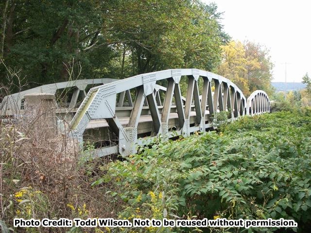
This bridge's trusses are completely composed of rolled beams. The most unusual feature of the bridge is the fact that the bottom chord connections to the lower gusset plates are pinned, which is quite unusual for a 1930s bridge. All other connections, including the diagonal members' bottom chord connections are riveted. The Historic Bridge Inventory notes this made it easy to assemble the bridge. The Inventory is either outdated or incorrect in saying this detail is common in the region. It is an unusual detail (only two bridges were known to exhibit this design at the time HistoricBridges.org documented the bridge), and the preservation of this bridge should be considered for this reason, and also the fact that the bridge appears to be in decent shape and thus easy to keep in service of properly maintained and preserved.
Information and Findings From Pennsylvania's Historic Bridge InventoryDiscussion of Bridge The 2 span, 259' long, Warren with polygonal top chord pony truss bridge is supported on concrete abutments with wingwallls and a concrete pier. The members are rolled section, and it has riveted connections save for the lower panel points that are pinned. The approximately 125' long spans are long for pony trusses, and the pinned lower chord connections are for ease of construction. Bridges with this detail are not uncommon in the region. Neither the 1931 bridge nor its setting and context are historically or technologically significant. Discussion of Surrounding Area The bridge carries a 2 lane road over a stream in a sparsely developed, wooded setting just north of the SR 982 and SR 30 cloverleaf. Bridge Considered Historic By Survey: No |
![]()
![]()
This historic bridge has been demolished. This map is shown for reference purposes only.
Coordinates (Latitude, Longitude):
Search For Additional Bridge Listings:
Bridgehunter.com: View listed bridges within 0.5 miles (0.8 kilometers) of this bridge.
Bridgehunter.com: View listed bridges within 10 miles (16 kilometers) of this bridge.
Additional Maps:
Google Streetview (If Available)
GeoHack (Additional Links and Coordinates)
Apple Maps (Via DuckDuckGo Search)
Apple Maps (Apple devices only)
Android: Open Location In Your Map or GPS App
Flickr Gallery (Find Nearby Photos)
Wikimedia Commons (Find Nearby Photos)
Directions Via Sygic For Android
Directions Via Sygic For iOS and Android Dolphin Browser
USGS National Map (United States Only)
Historical USGS Topo Maps (United States Only)
Historic Aerials (United States Only)
CalTopo Maps (United States Only)

© Copyright 2003-2024, HistoricBridges.org. All Rights Reserved. Disclaimer: HistoricBridges.org is a volunteer group of private citizens. HistoricBridges.org is NOT a government agency, does not represent or work with any governmental agencies, nor is it in any way associated with any government agency or any non-profit organization. While we strive for accuracy in our factual content, HistoricBridges.org offers no guarantee of accuracy. Information is provided "as is" without warranty of any kind, either expressed or implied. Information could include technical inaccuracies or errors of omission. Opinions and commentary are the opinions of the respective HistoricBridges.org member who made them and do not necessarily represent the views of anyone else, including any outside photographers whose images may appear on the page in which the commentary appears. HistoricBridges.org does not bear any responsibility for any consequences resulting from the use of this or any other HistoricBridges.org information. Owners and users of bridges have the responsibility of correctly following all applicable laws, rules, and regulations, regardless of any HistoricBridges.org information.
![]()