

View Information About HSR Ratings
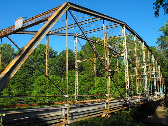
This bridge is an old and an increasingly rare example of a pin-connected Pennsylvania through truss bridge. Pennsylvania truss bridges have ironically become extremely rare in Pennsylvania, thanks to widespread demolition. Although the builder plaque is lost, the bridge appears to be one of the standard designs that the Pittsburgh Bridge Company and its agents Nelson and Buchannan used for longer truss spans such as this. The design of the commissioner's plaque and the portal bracing are the design used by that company. This particular bridge has good historic integrity, with only some scattered repairs and alterations from a 1959 rehabilitation.
This bridge could likely be restored for continued light vehicular use, especially if it were carefully marked and disassembled so that repairs could be made in a shop to the individual parts of the bridge. While this form of preservation sounds expensive, it often can cost less than the cost of a replacement bridge and it results in a bridge that is in like-new condition. However Pennsylvania has decided to continue its trend of widespread demolition and replacement of historic metal truss bridges, failing to give these bridges the same care and preservation that the Commonwealth's overrated wooden covered bridges have received in unfair proportions relative to other historic bridge types. Now, the only way the bridge will be saved is if a third party steps forward to relocate and preserve the bridge elsewhere.
PennDOT comments that the pole railings were added in 1959. However the pole railings appear to be original, with the lower metal guide curb being what appears to have been added in 1959.
Information and Findings From Pennsylvania's Historic Bridge InventoryDiscussion of Bridge The pin-connected, Parker thru truss with subidvided panels bridge was determined eligible as a result of the Section 106 consultation process. Discussion of Surrounding Area The bridge carries a 2 lane township road over a river in a sparsely developed, forested setting. The Reading Railroad is to the west of the river and the former Pennsylvania Railroad is to the east. Both were important lines in opening the coal fields. The Reading line is now known as the Reading Blue Mountain & Northern line. Bridge Considered Historic By Survey: Yes Information From PennDOT Bridge Marketing Website The Pennsylvania Department of Transportation,
Engineering District 5-0, and Berks County seek an interested party to
acquire the Berne Station Bridge. The bridge currently carries Fisher
Dam Road and Zweizig Road over the Schuylkill River between Tilden and
Perry Townships in Berks County. It is eligible for the National
Register of Historic Places under Criterion A for its association with
transportation and economic development in Berks County during the late
19th century, and under Criterion C as a well-preserved example of a
single-span Parker through truss located in a rural setting. The
concrete decking on metal deck pans and pipe railings were added in the
late 1950s. Due to structural deficiencies, the bridge has been closed
to vehicular traffic since 2006. |
![]()
![]()
![]()
This historic bridge has been demolished. This map is shown for reference purposes only.
Coordinates (Latitude, Longitude):
Search For Additional Bridge Listings:
Bridgehunter.com: View listed bridges within 0.5 miles (0.8 kilometers) of this bridge.
Bridgehunter.com: View listed bridges within 10 miles (16 kilometers) of this bridge.
Additional Maps:
Google Streetview (If Available)
GeoHack (Additional Links and Coordinates)
Apple Maps (Via DuckDuckGo Search)
Apple Maps (Apple devices only)
Android: Open Location In Your Map or GPS App
Flickr Gallery (Find Nearby Photos)
Wikimedia Commons (Find Nearby Photos)
Directions Via Sygic For Android
Directions Via Sygic For iOS and Android Dolphin Browser
USGS National Map (United States Only)
Historical USGS Topo Maps (United States Only)
Historic Aerials (United States Only)
CalTopo Maps (United States Only)

© Copyright 2003-2024, HistoricBridges.org. All Rights Reserved. Disclaimer: HistoricBridges.org is a volunteer group of private citizens. HistoricBridges.org is NOT a government agency, does not represent or work with any governmental agencies, nor is it in any way associated with any government agency or any non-profit organization. While we strive for accuracy in our factual content, HistoricBridges.org offers no guarantee of accuracy. Information is provided "as is" without warranty of any kind, either expressed or implied. Information could include technical inaccuracies or errors of omission. Opinions and commentary are the opinions of the respective HistoricBridges.org member who made them and do not necessarily represent the views of anyone else, including any outside photographers whose images may appear on the page in which the commentary appears. HistoricBridges.org does not bear any responsibility for any consequences resulting from the use of this or any other HistoricBridges.org information. Owners and users of bridges have the responsibility of correctly following all applicable laws, rules, and regulations, regardless of any HistoricBridges.org information.
![]()