

View Information About HSR Ratings

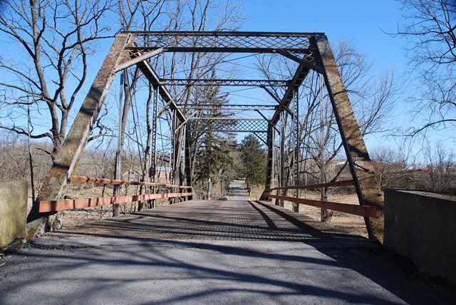
This bridge is a rare surviving example of a bridge built by the Climax Road Machine Company of Marathon, New York. This company appears to have been more noted for its manufacturing of equipment used to build roads and was likely not ever a major bridge builder. The substructure contractor for this bridge was Willauer Company. The bridge has been altered in some areas, notably with welded alterations on the bottom chord. Also, all the lateral bracing under the deck has been removed. Otherwise however, the bridge appears to be intact.
The Historic Bridge Inventory claims that the floor beams date to the 1956 alterations, however the floor beams have riveted details at the ends and appear to be original, so this statement appears to be in error.
Information and Findings From Pennsylvania's Historic Bridge InventoryDiscussion of Bridge The 5-panel, pin-connected, 81'-long Pratt thru truss bridge is supported on concrete abutments. The trusses are traditionally composed, and they have no innovative or distinctive details. Instead of the U-shaped hanger, rolled section floorbeams are connected to the pins by riveted pin plates at the ends of the floorbeams. The detail is not uncommon for the period, and it is not innovative or distinctive. It is one of two similar bridges by the fabricator in the county (06 7215 0787 9467 dates to 1904). The bridge is a later example of its type, and it is not historically or technologically significant. County records state the bridge was "rebuilt" in 1956, and it appears that the floor beams and deck date to the rebuilding. Discussion of Surrounding Area The bridge carries one lane of a 2 lane road over a stream in a sparsely developed, wooded and agricultural setting. Bridge Considered Historic By Survey: No |
![]()
![]()
![]()
Coordinates (Latitude, Longitude):
Search For Additional Bridge Listings:
Bridgehunter.com: View listed bridges within 0.5 miles (0.8 kilometers) of this bridge.
Bridgehunter.com: View listed bridges within 10 miles (16 kilometers) of this bridge.
Additional Maps:
Google Streetview (If Available)
GeoHack (Additional Links and Coordinates)
Apple Maps (Via DuckDuckGo Search)
Apple Maps (Apple devices only)
Android: Open Location In Your Map or GPS App
Flickr Gallery (Find Nearby Photos)
Wikimedia Commons (Find Nearby Photos)
Directions Via Sygic For Android
Directions Via Sygic For iOS and Android Dolphin Browser
USGS National Map (United States Only)
Historical USGS Topo Maps (United States Only)
Historic Aerials (United States Only)
CalTopo Maps (United States Only)

© Copyright 2003-2024, HistoricBridges.org. All Rights Reserved. Disclaimer: HistoricBridges.org is a volunteer group of private citizens. HistoricBridges.org is NOT a government agency, does not represent or work with any governmental agencies, nor is it in any way associated with any government agency or any non-profit organization. While we strive for accuracy in our factual content, HistoricBridges.org offers no guarantee of accuracy. Information is provided "as is" without warranty of any kind, either expressed or implied. Information could include technical inaccuracies or errors of omission. Opinions and commentary are the opinions of the respective HistoricBridges.org member who made them and do not necessarily represent the views of anyone else, including any outside photographers whose images may appear on the page in which the commentary appears. HistoricBridges.org does not bear any responsibility for any consequences resulting from the use of this or any other HistoricBridges.org information. Owners and users of bridges have the responsibility of correctly following all applicable laws, rules, and regulations, regardless of any HistoricBridges.org information.
![]()