

View Information About HSR Ratings
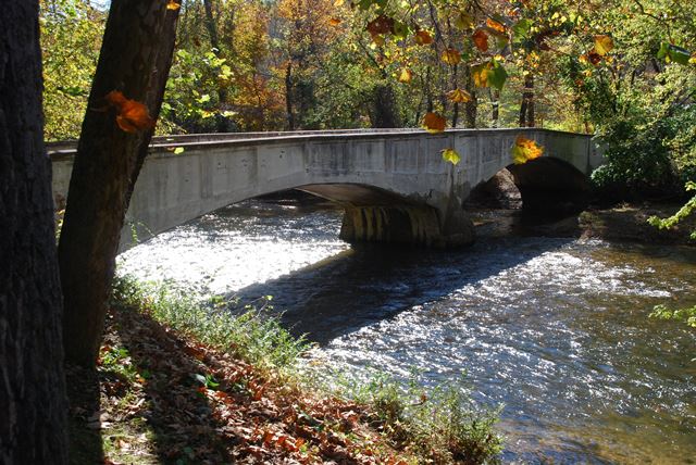
This bridge is one of two bridges with similar unusual architectural detailing in York County. The outside of the arches feature inset panels that do not distinguish between railing and spandrel wall, and extend down to the arch. Additionally, the railings are not horizontal, and have a slight incline at each end. This bridge retains good historic integrity.
Information and Findings From Pennsylvania's Historic Bridge InventoryDiscussion of Bridge The 2-span, 131'-long, reinforced concrete, elliptical arch bridge built in 1918 is supported on concrete abutments and bullnose pier. The reinforced concrete spandrel walls and parapets have oversize panels extending from just above the arch ring to the parapet coping. The bridge has the distinctive paneling of York County reinforced concrete arch bridges that were designed by County Engineer Charles Williams during the mid 1910s. It is one of at least 10 similar bridges from 1913 to 1918 identified in York County, and it is the only multiple span example. The bridge benefits from an undisturbed rural setting that is adjacent to the 19th century Glen Allen rural mill and farm complex that has historic district potential. The bridge, which replaced a previous covered bridge, dates from the mill's active period of operation. The bridge served to connect the mill with the farms on the south bank of Yellow Breeches Creek in York County. It is evaluated as contributing to the potential Glen Allen historic district. Discussion of Surrounding Area The bridge carries one lane of traffic over a stream that is the York-Cumberland county line. The south (York County) side of the stream is forested with no visible buildings. On the north (Cumberland) county side, at the northwest quadrant, is a 19th-century mill and farm complex known as Glen Allen. It includes the Glen Allen Mill (ca. 1835), a grist mill complete with machinery, a stone and log residence (ca. 1790 with 19th century additions) and a federal-style brick residence (ca. 1835) with period outbuildings. According to a local history, the mill operated continuously through the mid 1960s. Glen Allen has the significance, cohesiveness and integrity to be a historic district. Bridge Considered Historic By Survey: Yes |
![]()
![]()
![]()
Coordinates (Latitude, Longitude):
Search For Additional Bridge Listings:
Bridgehunter.com: View listed bridges within 0.5 miles (0.8 kilometers) of this bridge.
Bridgehunter.com: View listed bridges within 10 miles (16 kilometers) of this bridge.
Additional Maps:
Google Streetview (If Available)
GeoHack (Additional Links and Coordinates)
Apple Maps (Via DuckDuckGo Search)
Apple Maps (Apple devices only)
Android: Open Location In Your Map or GPS App
Flickr Gallery (Find Nearby Photos)
Wikimedia Commons (Find Nearby Photos)
Directions Via Sygic For Android
Directions Via Sygic For iOS and Android Dolphin Browser
USGS National Map (United States Only)
Historical USGS Topo Maps (United States Only)
Historic Aerials (United States Only)
CalTopo Maps (United States Only)

© Copyright 2003-2024, HistoricBridges.org. All Rights Reserved. Disclaimer: HistoricBridges.org is a volunteer group of private citizens. HistoricBridges.org is NOT a government agency, does not represent or work with any governmental agencies, nor is it in any way associated with any government agency or any non-profit organization. While we strive for accuracy in our factual content, HistoricBridges.org offers no guarantee of accuracy. Information is provided "as is" without warranty of any kind, either expressed or implied. Information could include technical inaccuracies or errors of omission. Opinions and commentary are the opinions of the respective HistoricBridges.org member who made them and do not necessarily represent the views of anyone else, including any outside photographers whose images may appear on the page in which the commentary appears. HistoricBridges.org does not bear any responsibility for any consequences resulting from the use of this or any other HistoricBridges.org information. Owners and users of bridges have the responsibility of correctly following all applicable laws, rules, and regulations, regardless of any HistoricBridges.org information.
![]()