

View Information About HSR Ratings

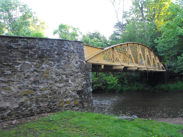
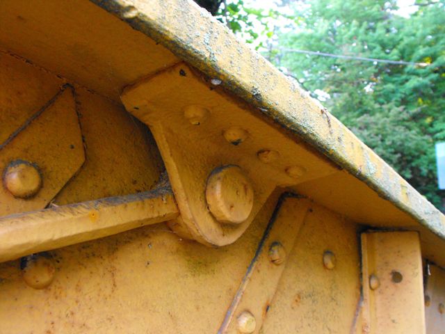
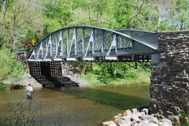
This bridge is one of the rarest and most unusual types and designs of bowstring truss bridges in the country, designed by bridge builder Thomas Moseley. The exact design type of this bridge is described by engineers as a form of tied arch and/or a lattice girder. However in terms of understanding the history of the bridge, interpreting the thinking that went into the design of the bridge, and observing the general appearance of the bridge, this structure has more in common with a bowstring truss bridge. Patents which display portions of this bridge's design describe the bridges as truss bridges, which shows that Thomas Moseley was thinking about the truss bridge not the arch bridge when designing his bridges. Built in 1869, the bridge is one of the earliest examples of a bowstring truss bridge, a bridge type that rapidly came and went, enjoying a brief, yet widespread popularity during the 1870s. Bowstring truss bridges are rare enough in their own right today, yet this bridge may be the last of its kind. Design significance aside, the bridge is also among the oldest metal bridges remaining in North America. As a result, its historic significance is nearly without compare among bridges in the United States.

While there is no single patent that reflects the exact design of this bridge, three patents made by Thomas Moseley are related to Moseley's bowstring bridge work. One, dating to 1870, just after this bridge was built has the most related designs. There were some other bridge patents that Moseley filed that may have inspired the design of this bridge and the 1870 patent that displays the most similar details to the Hares Hill Road Bridge, one dates to 1866 and the other dates to 1857.
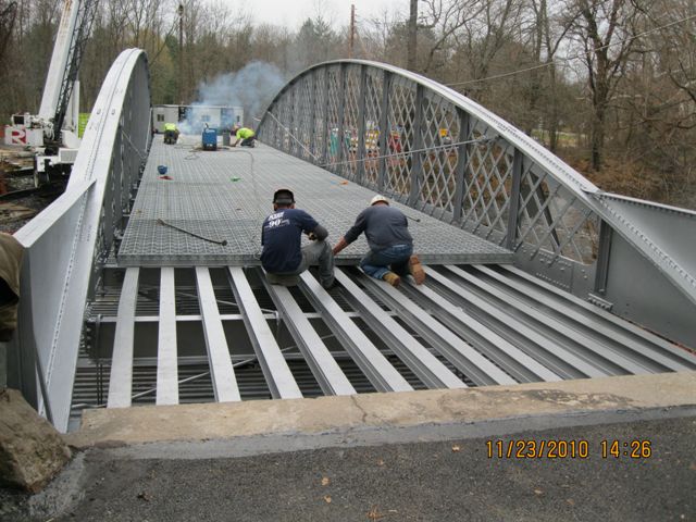
Fortunately, the future of this nationally significant bridge is good. In 2010, PennDOT chose to rehabilitate this historic bridge for continued vehicular use. The quality construction of the original bridge combined with the benefits of a rehabilitation will ensure that this historic bridge remains for many years to come. The decision to rehabilitate this bridge likely cost taxpayers less than a replacement bridge would have cost. The rehabilitation of this bridge also appears to have been well-designed and conducted in a manner respective to the historic integrity of the bridge. Some of the highlights in the scope of work included deck replacement and in-kind replacement of some of the vertical members. All metal on the bridge was cleaned and repainted in a beautiful silver color. Silver is a color that was often used on bridges in the past but is sadly not used often in more recent preservation projects. Silver is a nice choice for a truss bridge because while it doesn't look too bright, it helps the bridge stand out and be noticed. It is a particularly beautiful color for a bridge when seen in the summer time, where it contrasts with green leaves.
PennDOT commented that Resident Engineer for PennDOT: Michael Suchonic, Project Inspector: John Gallager with CMC, Inc., and Contractor: Road-Con, Inc were all involved with this project. HistoricBridges.org thanks these entities for their role in preserving this extremely important part of our nation's transportation heritage. Be sure to view the photo gallery page for this bridge, as there is a collection of photos courtesy PennDOT that show the rehabilitation of this bridge.
![]()
![]()
![]()
![]()
![]()
![]()
![]()
![]()

![]()
![]()
Coordinates (Latitude, Longitude):
Search For Additional Bridge Listings:
Bridgehunter.com: View listed bridges within 0.5 miles (0.8 kilometers) of this bridge.
Bridgehunter.com: View listed bridges within 10 miles (16 kilometers) of this bridge.
Additional Maps:
Google Streetview (If Available)
GeoHack (Additional Links and Coordinates)
Apple Maps (Via DuckDuckGo Search)
Apple Maps (Apple devices only)
Android: Open Location In Your Map or GPS App
Flickr Gallery (Find Nearby Photos)
Wikimedia Commons (Find Nearby Photos)
Directions Via Sygic For Android
Directions Via Sygic For iOS and Android Dolphin Browser
USGS National Map (United States Only)
Historical USGS Topo Maps (United States Only)
Historic Aerials (United States Only)
CalTopo Maps (United States Only)

© Copyright 2003-2024, HistoricBridges.org. All Rights Reserved. Disclaimer: HistoricBridges.org is a volunteer group of private citizens. HistoricBridges.org is NOT a government agency, does not represent or work with any governmental agencies, nor is it in any way associated with any government agency or any non-profit organization. While we strive for accuracy in our factual content, HistoricBridges.org offers no guarantee of accuracy. Information is provided "as is" without warranty of any kind, either expressed or implied. Information could include technical inaccuracies or errors of omission. Opinions and commentary are the opinions of the respective HistoricBridges.org member who made them and do not necessarily represent the views of anyone else, including any outside photographers whose images may appear on the page in which the commentary appears. HistoricBridges.org does not bear any responsibility for any consequences resulting from the use of this or any other HistoricBridges.org information. Owners and users of bridges have the responsibility of correctly following all applicable laws, rules, and regulations, regardless of any HistoricBridges.org information.
![]()