

View Information About HSR Ratings
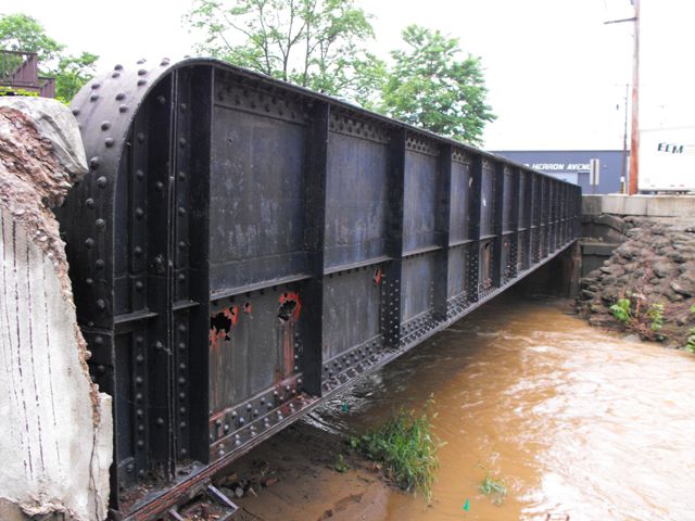
This bridge is a good example of a traditionally composed highway plate girder. While railroad plate girders remain common nationwide, some states did not build many highway plate girders. However, Pennsylvania was one state which did build a large number of highway plate girders. This example retains good historic integrity. Structurally, it suffers from areas of 100% section loss on the web of the girder. Dispite the alarming appearance of this section loss, structurally the girder remains a strong and capable structure.
Information and Findings From Pennsylvania's Historic Bridge InventoryDiscussion of Bridge The 1931, skewed, single span, built up thru girder bridge is supported on concrete abutments. The bridge has a steel plate asphalt filled corrugated pan deck. The cantilevered sidewalk has a 2 rail high metal pipe rail railing. The bridge is an example of a common type with no innovative or distinguishing detail. Girder bridges were first developed by the railroad industry in the 1850s, and they were used on vehicular roadways in Allegheny County beginning in the late 19th century. Neither the bridge nor its setting and context are historically or technologically noteworthy. Discussion of Surrounding Area The bridge carries 1 lane of a street and 1 sidewalk over a stream in an area dominated by commercial and industrial buildings, with scattered mid- and late-20th century residences. The area does not appear to have historic district potential. Bridge Considered Historic By Survey: No |
![]()
![]()
![]()
This historic bridge has been demolished. This map is shown for reference purposes only.
Coordinates (Latitude, Longitude):
Search For Additional Bridge Listings:
Bridgehunter.com: View listed bridges within 0.5 miles (0.8 kilometers) of this bridge.
Bridgehunter.com: View listed bridges within 10 miles (16 kilometers) of this bridge.
Additional Maps:
Google Streetview (If Available)
GeoHack (Additional Links and Coordinates)
Apple Maps (Via DuckDuckGo Search)
Apple Maps (Apple devices only)
Android: Open Location In Your Map or GPS App
Flickr Gallery (Find Nearby Photos)
Wikimedia Commons (Find Nearby Photos)
Directions Via Sygic For Android
Directions Via Sygic For iOS and Android Dolphin Browser
USGS National Map (United States Only)
Historical USGS Topo Maps (United States Only)
Historic Aerials (United States Only)
CalTopo Maps (United States Only)

© Copyright 2003-2024, HistoricBridges.org. All Rights Reserved. Disclaimer: HistoricBridges.org is a volunteer group of private citizens. HistoricBridges.org is NOT a government agency, does not represent or work with any governmental agencies, nor is it in any way associated with any government agency or any non-profit organization. While we strive for accuracy in our factual content, HistoricBridges.org offers no guarantee of accuracy. Information is provided "as is" without warranty of any kind, either expressed or implied. Information could include technical inaccuracies or errors of omission. Opinions and commentary are the opinions of the respective HistoricBridges.org member who made them and do not necessarily represent the views of anyone else, including any outside photographers whose images may appear on the page in which the commentary appears. HistoricBridges.org does not bear any responsibility for any consequences resulting from the use of this or any other HistoricBridges.org information. Owners and users of bridges have the responsibility of correctly following all applicable laws, rules, and regulations, regardless of any HistoricBridges.org information.
![]()