

View Information About HSR Ratings

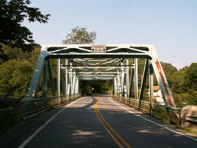
This bridge is a relatively small example of Pennsylvania's very attractive standard plan 1930s/40s truss bridge design. As such, it features a shallower portal bracing design that other bridges built to this standard. These 1930s/40s bridges in Pennsylvania are becoming increasingly rare as PennDOT goes around demolishing them, partly aided by the fact that none of these bridges were assessed as historic by the historic bridge inventory. The loss of these bridges, which are wide and sturdy enough to support modern traffic if maintained, is a serious blow to what makes the Pennsylvania landscape so beautiful and enjoyable to travel through.
Fortunately, PennDOT had a change of heart with this bridge and chose to rehabilitate it in 2009. PennDOT deserves to be thanked for choosing to rehabilitate this bridge instead of replacing it, representing a good preservation project and also a wise use of tax dollars.
Information and Findings From Pennsylvania's Historic Bridge InventoryDiscussion of Bridge The 1941, skewed, 158'-long, riveted Parker thru truss bridge is supported on ashlar abutments with concrete caps. The trusses are traditionally composed with the upper and lower chords being built up box sections, and the verticals and diagonals rolled I sections. Lateral and sway bracing are laced channels. The deck is reinforced concrete, and the steel railings inside the truss lines are original. The bridge has no innovative or distinctive details. Use of rolled section for truss members was common after 1930. The Parker truss was commonly used by PennDOT for span lengths greater than 125' in the 1930s. Neither the 1941 bridge nor its setting are historically or technologically significant. Discussion of Surrounding Area The bridge carries a 2 lane road over a stream in a sparsely developed, wooded setting. There are highly altered ca. 1910 vernacular houses along the stream to the east of and below the bridge. There are also a couple of houses on the east side of the at grade railroad crossing north and west of the bridge. The approximately 6 buildings in the area do not have the significance or integrity to be a historic district. Bridge Considered Historic By Survey: No |
![]()
![]()
Coordinates (Latitude, Longitude):
Search For Additional Bridge Listings:
Bridgehunter.com: View listed bridges within 0.5 miles (0.8 kilometers) of this bridge.
Bridgehunter.com: View listed bridges within 10 miles (16 kilometers) of this bridge.
Additional Maps:
Google Streetview (If Available)
GeoHack (Additional Links and Coordinates)
Apple Maps (Via DuckDuckGo Search)
Apple Maps (Apple devices only)
Android: Open Location In Your Map or GPS App
Flickr Gallery (Find Nearby Photos)
Wikimedia Commons (Find Nearby Photos)
Directions Via Sygic For Android
Directions Via Sygic For iOS and Android Dolphin Browser
USGS National Map (United States Only)
Historical USGS Topo Maps (United States Only)
Historic Aerials (United States Only)
CalTopo Maps (United States Only)

© Copyright 2003-2024, HistoricBridges.org. All Rights Reserved. Disclaimer: HistoricBridges.org is a volunteer group of private citizens. HistoricBridges.org is NOT a government agency, does not represent or work with any governmental agencies, nor is it in any way associated with any government agency or any non-profit organization. While we strive for accuracy in our factual content, HistoricBridges.org offers no guarantee of accuracy. Information is provided "as is" without warranty of any kind, either expressed or implied. Information could include technical inaccuracies or errors of omission. Opinions and commentary are the opinions of the respective HistoricBridges.org member who made them and do not necessarily represent the views of anyone else, including any outside photographers whose images may appear on the page in which the commentary appears. HistoricBridges.org does not bear any responsibility for any consequences resulting from the use of this or any other HistoricBridges.org information. Owners and users of bridges have the responsibility of correctly following all applicable laws, rules, and regulations, regardless of any HistoricBridges.org information.
![]()