

View Information About HSR Ratings

Some places (like the entire state of Michigan) do not have a single bridge like this. Although there are more examples of this technology in Pennsylvania, this does not mean these bridges are common and unworthy of preservation. At least some of these bridges should be preserved. The Hooversville Bridge seems like an excellent candidate.
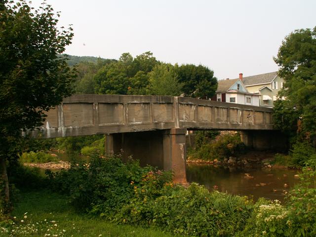
This bridge is essentially a "normal" two-span through plate girder that is encased in concrete. Engineers experimented with concrete encasing in the early twentieth century in an attempt to try to protect and prolong the life of the steel. The technique did not last however, and by 1940 was in general no longer used.
The plate girder itself can in fact be seen today because at the ends of the bridge the concrete has deteriorated slightly, revealing the ends of the girders. Also, the shape of the concrete is similar to a plate girder, where one can see the ribs on the concrete, which cover the ribs that appear on most plate girder walls.
Information and Findings From Pennsylvania's Historic Bridge InventoryDiscussion of Bridge The 1914, 2 simple span, 166'-long (2 @ 83'), built up thru girder bridge is supported on concrete abutments and a concrete pier. The bridge, which has a camber, is completely encased in concrete. The bridge is an example of a common type with no innovative or distinguishing detail. Girder bridges were first developed by the railroad industry in the 1840s, and they were used on vehicular roadways in Pennsylvania beginning in the late 19th century. Neither the bridge nor its setting are historically or technologically significant. Discussion of Surrounding Area The bridge carries a 2 lane of a borough street and 1 sidewalk over a river in the central part of Hooversville with undistinguished and altered late-19th and early-20th century houses and commercial buildings. Many have modern additions, replacement siding and windows, and rebuilt or lost porches. The area lacks the cohesiveness and architectural significance to be a potential historic district. Bridge Considered Historic By Survey: No |
![]()
![]()
This historic bridge has been demolished. This map is shown for reference purposes only.
Coordinates (Latitude, Longitude):
Search For Additional Bridge Listings:
Bridgehunter.com: View listed bridges within 0.5 miles (0.8 kilometers) of this bridge.
Bridgehunter.com: View listed bridges within 10 miles (16 kilometers) of this bridge.
Additional Maps:
Google Streetview (If Available)
GeoHack (Additional Links and Coordinates)
Apple Maps (Via DuckDuckGo Search)
Apple Maps (Apple devices only)
Android: Open Location In Your Map or GPS App
Flickr Gallery (Find Nearby Photos)
Wikimedia Commons (Find Nearby Photos)
Directions Via Sygic For Android
Directions Via Sygic For iOS and Android Dolphin Browser
USGS National Map (United States Only)
Historical USGS Topo Maps (United States Only)
Historic Aerials (United States Only)
CalTopo Maps (United States Only)

© Copyright 2003-2024, HistoricBridges.org. All Rights Reserved. Disclaimer: HistoricBridges.org is a volunteer group of private citizens. HistoricBridges.org is NOT a government agency, does not represent or work with any governmental agencies, nor is it in any way associated with any government agency or any non-profit organization. While we strive for accuracy in our factual content, HistoricBridges.org offers no guarantee of accuracy. Information is provided "as is" without warranty of any kind, either expressed or implied. Information could include technical inaccuracies or errors of omission. Opinions and commentary are the opinions of the respective HistoricBridges.org member who made them and do not necessarily represent the views of anyone else, including any outside photographers whose images may appear on the page in which the commentary appears. HistoricBridges.org does not bear any responsibility for any consequences resulting from the use of this or any other HistoricBridges.org information. Owners and users of bridges have the responsibility of correctly following all applicable laws, rules, and regulations, regardless of any HistoricBridges.org information.
![]()