

View Information About HSR Ratings

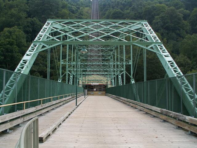
This bridge was built solely to provide access to the Johnstown Incline, which provides transportation up to what was originally a Cambria Iron Company sponsored residential development called Westmont. It was also created in response to the 1889 Johnstown Flood, since this facility could provide a way for residents of Johnstown to escape to high ground in the event of a flood. The bridge and incline did indeed later serve this purpose in a 1936 flood. As such, this bridge is significant for its association with the flood response, and with the incline which is a significant engineering feat in its own right, and one of very few remaining examples of an incline of this size.
This bridge itself is significant as an example of an uncommon and complex truss configuration, the Pennsylvania truss. The bridge has a rather wide deck for an 1890 bridge. The length of the bridge is significant, although it falls short of the average length for this truss configuration. It may be that this truss configuration was selected to give the bridge extra strength to withstand any floods.
The bridge has been rehabilitated over the years and as such some of the original design integrity has been lost. The observant bridge enthusiast may note these alterations. However, the overall materials and design of the bridge remains intact. The cyclone fence present on the bridge is perhaps the most notable and unsightly modern addition to the bridge. It would be nice to see this replaced with a barrier that does not obstruct the view of the truss and its details.

![]()
![]()
Coordinates (Latitude, Longitude):
Search For Additional Bridge Listings:
Bridgehunter.com: View listed bridges within 0.5 miles (0.8 kilometers) of this bridge.
Bridgehunter.com: View listed bridges within 10 miles (16 kilometers) of this bridge.
Additional Maps:
Google Streetview (If Available)
GeoHack (Additional Links and Coordinates)
Apple Maps (Via DuckDuckGo Search)
Apple Maps (Apple devices only)
Android: Open Location In Your Map or GPS App
Flickr Gallery (Find Nearby Photos)
Wikimedia Commons (Find Nearby Photos)
Directions Via Sygic For Android
Directions Via Sygic For iOS and Android Dolphin Browser
USGS National Map (United States Only)
Historical USGS Topo Maps (United States Only)
Historic Aerials (United States Only)
CalTopo Maps (United States Only)

© Copyright 2003-2024, HistoricBridges.org. All Rights Reserved. Disclaimer: HistoricBridges.org is a volunteer group of private citizens. HistoricBridges.org is NOT a government agency, does not represent or work with any governmental agencies, nor is it in any way associated with any government agency or any non-profit organization. While we strive for accuracy in our factual content, HistoricBridges.org offers no guarantee of accuracy. Information is provided "as is" without warranty of any kind, either expressed or implied. Information could include technical inaccuracies or errors of omission. Opinions and commentary are the opinions of the respective HistoricBridges.org member who made them and do not necessarily represent the views of anyone else, including any outside photographers whose images may appear on the page in which the commentary appears. HistoricBridges.org does not bear any responsibility for any consequences resulting from the use of this or any other HistoricBridges.org information. Owners and users of bridges have the responsibility of correctly following all applicable laws, rules, and regulations, regardless of any HistoricBridges.org information.
![]()