

View Information About HSR Ratings
Among the state-designed truss bridges of the 1920s-1940s, this bridge has one of the most uncommon portal bracing designs. Another example of this portal design was seen on the Millsboro Bridge. The McClintock Bridge is a two-span Pratt through truss bridge. Each span is composed of seven panels. There is lattice under the top chord. A cantilevered sidewalk, which features lattice railings, is present on the west side of the bridge. Original railings do not remain on the bridge and modern Armco railings have been added. The bridge is fairly wide, and vertical clearance is reasonable on this bridge. The bridge is a functional crossing that also has a great deal of aesthetic value. The finding of this bridge as not historic is the result of the decision to consider all nearly all standard plan truss bridges in Pennsylvania as not historic. This decision does not reflect the potential factors a bridge might have for National Register eligibility in terms of being a good representative example of a period of time in the history of bridge construction. At the least, a number of these state standard truss bridges should be considered National Register eligible as good representative examples. This bridge should be considered eligible as an uncommon example of its portal bracing design. Given the dimensions of the bridge and the overall condition of the bridge, rehabilitating and preserving the bridge makes sense, and is a logical course of action that would likely also represent a sound fiscal decision as well. What, then, is the fate of this bridge? PennDOT plans to demolish and replace this bridge with a slab of pre-stressed concrete box beams.
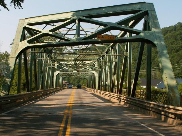
Information and Findings From Pennsylvania's Historic Bridge InventoryDiscussion of Bridge The 1930, riveted, skewed, 2 span, 312'-long (2 @ 156'), Pratt thru truss bridge is supported on concrete abutments with flared wingwalls and a concrete pier. The trusses have built up upper and lower chords and rolled I section verticals and diagonals. Built to a state highway department standard design that was used with great frequency since in the mid 1920s, the bridge has no innovative or distinctive details. SR 8 traversed the west side of the state from Waynesburg (Greene County) to Erie, passing through Pittsburgh. One of more than a half dozen north-south, trans-state routes, its traffic was mostly local in nature. Neither the bridge nor its setting are historically or technologically significant. Discussion of Surrounding Area The bridge carries a 2 lane road and a sidewalk over a stream south of Rouseville. At the northwest quadrant is a modern oil refinery. Across the road is an abandoned cinder block factory building. The other quadrants are wooded. The area does not have historic district potential. Bridge Considered Historic By Survey: No |
![]()
![]()
![]()
This historic bridge has been demolished. This map is shown for reference purposes only.
Coordinates (Latitude, Longitude):
Search For Additional Bridge Listings:
Bridgehunter.com: View listed bridges within 0.5 miles (0.8 kilometers) of this bridge.
Bridgehunter.com: View listed bridges within 10 miles (16 kilometers) of this bridge.
Additional Maps:
Google Streetview (If Available)
GeoHack (Additional Links and Coordinates)
Apple Maps (Via DuckDuckGo Search)
Apple Maps (Apple devices only)
Android: Open Location In Your Map or GPS App
Flickr Gallery (Find Nearby Photos)
Wikimedia Commons (Find Nearby Photos)
Directions Via Sygic For Android
Directions Via Sygic For iOS and Android Dolphin Browser
USGS National Map (United States Only)
Historical USGS Topo Maps (United States Only)
Historic Aerials (United States Only)
CalTopo Maps (United States Only)

© Copyright 2003-2024, HistoricBridges.org. All Rights Reserved. Disclaimer: HistoricBridges.org is a volunteer group of private citizens. HistoricBridges.org is NOT a government agency, does not represent or work with any governmental agencies, nor is it in any way associated with any government agency or any non-profit organization. While we strive for accuracy in our factual content, HistoricBridges.org offers no guarantee of accuracy. Information is provided "as is" without warranty of any kind, either expressed or implied. Information could include technical inaccuracies or errors of omission. Opinions and commentary are the opinions of the respective HistoricBridges.org member who made them and do not necessarily represent the views of anyone else, including any outside photographers whose images may appear on the page in which the commentary appears. HistoricBridges.org does not bear any responsibility for any consequences resulting from the use of this or any other HistoricBridges.org information. Owners and users of bridges have the responsibility of correctly following all applicable laws, rules, and regulations, regardless of any HistoricBridges.org information.
![]()