

View Information About HSR Ratings
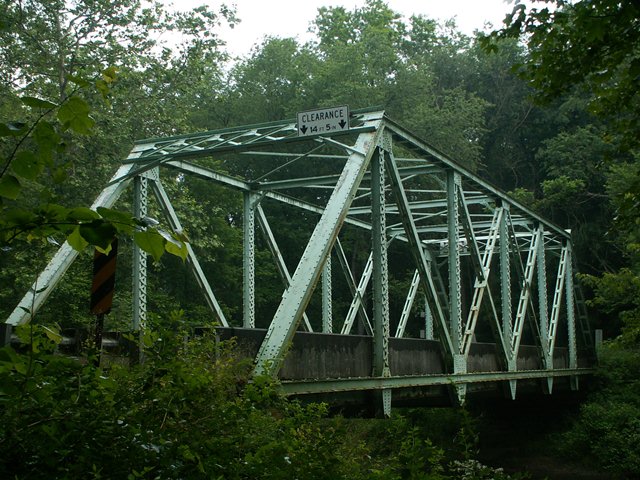
This is a six panel steel through truss with riveted connections. The bridge features v-lacing on the verticals and the bottom chord, and the portal bracing is a lattice design. The bridge's members are semi-massive, more so than the classic pin connected through truss, but not truly heavy like those found on Pennsylvania's U.S. and state highways. This bridge proves that riveted truss bridges built later in the truss bridge era can still have an attractive appearance to them, and blend into a forested setting in a manner similar to their pin connected ancestors. The beauty of metal truss bridges like this one is that while the trusses offer a geometric art that draws the eye, at the same time, the fact that this bridges steel is spread out throughout a truss web, it does not obstruct or block the view of its surroundings like a solid steel stringer bridge with its large, wall-like beams might.
Information and Findings From Pennsylvania's Historic Bridge InventoryDiscussion of Bridge The 1922, riveted, single span, 104'-long, Pratt thru truss bridge is supported on ashlar abutments with concrete caps. The heavy trusses, designed to handle to high load capacity, are composed of built up members. The bridge has no innovative or distinctive details. It is a late example of a common technology used in Pennsylvania since ca. 1890 and built with frequency by both county and state highway bridge builders in the 20th century. Neither the bridge nor its setting are historically or technologically significant. Discussion of Surrounding Area The bridge carries 1 lane of a road over a stream in a sparsely developed, forested setting near Hope Mills. The area does not have historic district potential. Bridge Considered Historic By Survey: No Information From www.mercercotrussbridges.com Demolition Mitigation WebsiteDiscussion of Bridge The trusses of the single span, riveted Pratt Through Truss bridge are composed of heavy trusses designed to carry heavy loads. The abutments are ashlar, or dressed stone. |
![]()
![]()
![]()
Coordinates (Latitude, Longitude):
Search For Additional Bridge Listings:
Bridgehunter.com: View listed bridges within 0.5 miles (0.8 kilometers) of this bridge.
Bridgehunter.com: View listed bridges within 10 miles (16 kilometers) of this bridge.
Additional Maps:
Google Streetview (If Available)
GeoHack (Additional Links and Coordinates)
Apple Maps (Via DuckDuckGo Search)
Apple Maps (Apple devices only)
Android: Open Location In Your Map or GPS App
Flickr Gallery (Find Nearby Photos)
Wikimedia Commons (Find Nearby Photos)
Directions Via Sygic For Android
Directions Via Sygic For iOS and Android Dolphin Browser
USGS National Map (United States Only)
Historical USGS Topo Maps (United States Only)
Historic Aerials (United States Only)
CalTopo Maps (United States Only)

© Copyright 2003-2024, HistoricBridges.org. All Rights Reserved. Disclaimer: HistoricBridges.org is a volunteer group of private citizens. HistoricBridges.org is NOT a government agency, does not represent or work with any governmental agencies, nor is it in any way associated with any government agency or any non-profit organization. While we strive for accuracy in our factual content, HistoricBridges.org offers no guarantee of accuracy. Information is provided "as is" without warranty of any kind, either expressed or implied. Information could include technical inaccuracies or errors of omission. Opinions and commentary are the opinions of the respective HistoricBridges.org member who made them and do not necessarily represent the views of anyone else, including any outside photographers whose images may appear on the page in which the commentary appears. HistoricBridges.org does not bear any responsibility for any consequences resulting from the use of this or any other HistoricBridges.org information. Owners and users of bridges have the responsibility of correctly following all applicable laws, rules, and regulations, regardless of any HistoricBridges.org information.
![]()