


View Information About HSR Ratings
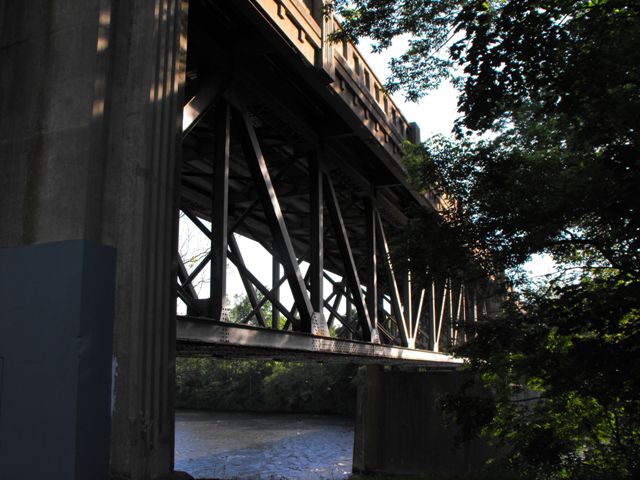
This bridge is a very long bridge, the result of a large number of approach spans that lead up to two main deck truss spans. The bridge is unaltered, but its relatively young age limits its historic value. However, the bridge is a very attractive structure, largely due to the attractive detailing on the concrete railings, combined with geometric art of the main truss spans which are quite handsomely decorated for a 1950s bridge.
This bridge is nearly impossible to photograph in the summer without a boat. HistoricBridges.org only has a limited selection of photos for this bridge as a result.
Information and Findings From Pennsylvania's Historic Bridge InventoryDiscussion of Bridge The 14 span viaduct is 1,167' long, with 2 riveted Pratt deck truss spans of 149' each and 12 spans of rolled section stringers. It is finished with architectonic concrete balustrades and accenting of the concrete substructure in the Art Moderne style. Built in 1953, the bridge is not an early example of the riveted Pratt truss, which has been used since the late 19th century. The viaduct is large and complete, but it is not historically or technologically significant, and it is not located in or associated with any historic districts. Discussion of Surrounding Area The viaduct carries a 2 lane with a sidewalk and a safety walk over the Lehigh River, railroads, and a canal. On the east bank of the river is the abandoned Lehigh Canal and active tracks of Conrail, lines established by the Central RR of NJ in the late 1860s. The canal right-of-way of the canal is a National Register-listed historic district with a period of significance from 1840 to 1931, the active years of the canal. On the west bank of the river, the bridge spans over a 2 lane city street, and an active track of Conrail, the former lines of the Lehigh Valley RR, established in the early 1850s. At the north end of the bridge is an early- to mid-20th century residential neighborhood of highly altered houses in West Catasauqua. The neighborhood does not appear to have historic district potential. Bridge Considered Historic By Survey: No |
This bridge is tagged with the following special condition(s): Unorganized Photos
![]()
![]()
![]()
![]()
![]()
Coordinates (Latitude, Longitude):
Search For Additional Bridge Listings:
Bridgehunter.com: View listed bridges within 0.5 miles (0.8 kilometers) of this bridge.
Bridgehunter.com: View listed bridges within 10 miles (16 kilometers) of this bridge.
Additional Maps:
Google Streetview (If Available)
GeoHack (Additional Links and Coordinates)
Apple Maps (Via DuckDuckGo Search)
Apple Maps (Apple devices only)
Android: Open Location In Your Map or GPS App
Flickr Gallery (Find Nearby Photos)
Wikimedia Commons (Find Nearby Photos)
Directions Via Sygic For Android
Directions Via Sygic For iOS and Android Dolphin Browser
USGS National Map (United States Only)
Historical USGS Topo Maps (United States Only)
Historic Aerials (United States Only)
CalTopo Maps (United States Only)

© Copyright 2003-2024, HistoricBridges.org. All Rights Reserved. Disclaimer: HistoricBridges.org is a volunteer group of private citizens. HistoricBridges.org is NOT a government agency, does not represent or work with any governmental agencies, nor is it in any way associated with any government agency or any non-profit organization. While we strive for accuracy in our factual content, HistoricBridges.org offers no guarantee of accuracy. Information is provided "as is" without warranty of any kind, either expressed or implied. Information could include technical inaccuracies or errors of omission. Opinions and commentary are the opinions of the respective HistoricBridges.org member who made them and do not necessarily represent the views of anyone else, including any outside photographers whose images may appear on the page in which the commentary appears. HistoricBridges.org does not bear any responsibility for any consequences resulting from the use of this or any other HistoricBridges.org information. Owners and users of bridges have the responsibility of correctly following all applicable laws, rules, and regulations, regardless of any HistoricBridges.org information.
![]()