

View Information About HSR Ratings
This bridge is a seven panel Pratt through truss with pinned connections. It is a traditionally composed structure, and it dates to the older of the two main decades for pin-connected truss bridges, the 1880s and 1890s. The plaque has been stolen, but the bridge once had a Smith Bridge Company plaque on it. The bridge features traditional structural element design characteristic of Smith Bridge Company bridges from the period, including battens under the built-up top chord and end post, sway bracing that is a rolled beam, and the design of lattice portal bracing arrangement. The bridge is historically significant as a good example of this noteworthy company's work.
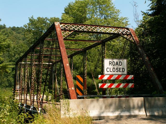
This bridge was damaged by a vehicle collision, and now PennDOT intends to use that as a great excuse to demolish this beautiful historic structure. The situation with this bridge illustrates the importance of preserving bridges now, before this sort of thing happens. Preservation solutions are available for bridges which are restored for continued vehicular traffic which allow the original railings to remain while also adding small, crash-resistant railings that protect the superstructure. PennDOT's decision to demolish this bridge, even in its condition, is highly disappointing. The bridge could certainly be placed in use for pedestrian use. PennDOT needs to design a comprehensive preservation plan for its historic bridges that would allow for extensive funding to preserve these beautiful historic bridges that play a large role in making Pennsylvania such a wonderful and cultural place to visit.
Below is a photo of the interpretive signage created to fulfill Section 106 mitigation for the adverse effect of demolishing the bridge. Click on it for an enlarged view. Photo courtesy PennDOT.

![]()
![]()
This historic bridge has been demolished. This map is shown for reference purposes only.
Coordinates (Latitude, Longitude):
Search For Additional Bridge Listings:
Bridgehunter.com: View listed bridges within 0.5 miles (0.8 kilometers) of this bridge.
Bridgehunter.com: View listed bridges within 10 miles (16 kilometers) of this bridge.
Additional Maps:
Google Streetview (If Available)
GeoHack (Additional Links and Coordinates)
Apple Maps (Via DuckDuckGo Search)
Apple Maps (Apple devices only)
Android: Open Location In Your Map or GPS App
Flickr Gallery (Find Nearby Photos)
Wikimedia Commons (Find Nearby Photos)
Directions Via Sygic For Android
Directions Via Sygic For iOS and Android Dolphin Browser
USGS National Map (United States Only)
Historical USGS Topo Maps (United States Only)
Historic Aerials (United States Only)
CalTopo Maps (United States Only)

© Copyright 2003-2024, HistoricBridges.org. All Rights Reserved. Disclaimer: HistoricBridges.org is a volunteer group of private citizens. HistoricBridges.org is NOT a government agency, does not represent or work with any governmental agencies, nor is it in any way associated with any government agency or any non-profit organization. While we strive for accuracy in our factual content, HistoricBridges.org offers no guarantee of accuracy. Information is provided "as is" without warranty of any kind, either expressed or implied. Information could include technical inaccuracies or errors of omission. Opinions and commentary are the opinions of the respective HistoricBridges.org member who made them and do not necessarily represent the views of anyone else, including any outside photographers whose images may appear on the page in which the commentary appears. HistoricBridges.org does not bear any responsibility for any consequences resulting from the use of this or any other HistoricBridges.org information. Owners and users of bridges have the responsibility of correctly following all applicable laws, rules, and regulations, regardless of any HistoricBridges.org information.
![]()