

View Information About HSR Ratings
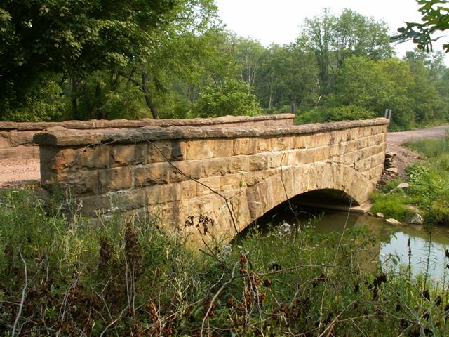
This bridge is one of a number of remaining stone arch bridges in Somerset County. The Historic Bridge Inventory singled this bridge out to be considered non-historic. However it is worth noting they did this only because older examples remain. On its own, this bridge is really just as interesting as the other bridges, although it does perhaps have a slightly less impressive arch span. It does have nice and tall stone parapets (railings) that are attractively capped off with stone slabs.
Information and Findings From Pennsylvania's Historic Bridge InventoryDiscussion of Bridge The 40'-long and 19' wide stone arch bridge built ca. 1914 is laid up in rusticated ashlar. The corresponding parapets step down over the flared wingwalls. The bridge retains its original masonry pattern and crisp mortar joints, and it appears to be complete. It is, however, the newest of the seven nearly identical stone arch bridges dating from ca. 1905 to ca. 1915 in the county. It is the early and complete examples that are significant. This bridge, a late example of its technology, is not historically or technologically significant. The bridge is identical to 55101000600000 that was built in 1914. Discussion of Surrounding Area The bridge carries 1 lane of an unimproved township road over a stream in a rural area of scattered early-20th century residences and active farms north of the village of Reading Mines. Just north of the bridge is the T intersection with TR 647. To the west of the bridge is an undistinguished early-20th century farm. Other residences in the area are heavily altered. The area lacks the concentration of resources to be a potential historic district. Bridge Considered Historic By Survey: No |
![]()
![]()
Coordinates (Latitude, Longitude):
Search For Additional Bridge Listings:
Bridgehunter.com: View listed bridges within 0.5 miles (0.8 kilometers) of this bridge.
Bridgehunter.com: View listed bridges within 10 miles (16 kilometers) of this bridge.
Additional Maps:
Google Streetview (If Available)
GeoHack (Additional Links and Coordinates)
Apple Maps (Via DuckDuckGo Search)
Apple Maps (Apple devices only)
Android: Open Location In Your Map or GPS App
Flickr Gallery (Find Nearby Photos)
Wikimedia Commons (Find Nearby Photos)
Directions Via Sygic For Android
Directions Via Sygic For iOS and Android Dolphin Browser
USGS National Map (United States Only)
Historical USGS Topo Maps (United States Only)
Historic Aerials (United States Only)
CalTopo Maps (United States Only)

© Copyright 2003-2024, HistoricBridges.org. All Rights Reserved. Disclaimer: HistoricBridges.org is a volunteer group of private citizens. HistoricBridges.org is NOT a government agency, does not represent or work with any governmental agencies, nor is it in any way associated with any government agency or any non-profit organization. While we strive for accuracy in our factual content, HistoricBridges.org offers no guarantee of accuracy. Information is provided "as is" without warranty of any kind, either expressed or implied. Information could include technical inaccuracies or errors of omission. Opinions and commentary are the opinions of the respective HistoricBridges.org member who made them and do not necessarily represent the views of anyone else, including any outside photographers whose images may appear on the page in which the commentary appears. HistoricBridges.org does not bear any responsibility for any consequences resulting from the use of this or any other HistoricBridges.org information. Owners and users of bridges have the responsibility of correctly following all applicable laws, rules, and regulations, regardless of any HistoricBridges.org information.
![]()