

View Information About HSR Ratings
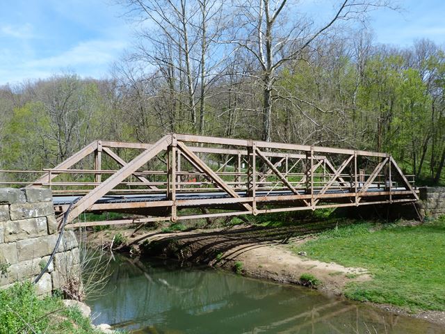
This bridge sits in its original location, but carries a trail in Ryerson Station State Park. This trail follows an abandoned stretch of McNay Ridge Road. The bridge is the reason for the name of the trail: Iron Bridge Trail. It is one of the only preserved historic truss bridges in southwestern Pennsylvania. The bridge is a late example of a pin-connected truss bridge and omits the use of eyebars for diagonals except for the counters, which is not unusual among late pin-connected truss bridges. The built-up top chord and end posts have an uncommon appearance because the flanges of the channels face inward, not outward.
Information and Findings From Pennsylvania's Historic Bridge InventoryDiscussion of Bridge The 96' long and 17' wide pin connected Pratt pony truss bridge supported on ashlar abutments with wingwalls has the floor beams placed above the lower chords. The bridge is dated 1914 making it a late example of its design. The trusses are traditionally composed, and the floor beams are rolled sections. There are some welded replacement of original members, especially at the lower chords. With no innovative or distinctive details, the bridge is not historically or technologically significant. Discussion of Surrounding Area The pedestrian bridge carried a park road over a stream in a sparsely developed, wooded setting in Ryerson Station State Park. The bridge, which is closed to vehicular traffic, connects a local road to a trail and picnic area. The land for the 1,164-acre park that has as its focus the 62 acre lake was acquired in 1958. The lake was created in 1960. The park was opened to the public in 1967. It was named for the 1792 Fort Ryerson. The park is not a potential historic district. Bridge Considered Historic By Survey: No |
![]()
![]()
![]()
Coordinates (Latitude, Longitude):
Search For Additional Bridge Listings:
Bridgehunter.com: View listed bridges within 0.5 miles (0.8 kilometers) of this bridge.
Bridgehunter.com: View listed bridges within 10 miles (16 kilometers) of this bridge.
Additional Maps:
Google Streetview (If Available)
GeoHack (Additional Links and Coordinates)
Apple Maps (Via DuckDuckGo Search)
Apple Maps (Apple devices only)
Android: Open Location In Your Map or GPS App
Flickr Gallery (Find Nearby Photos)
Wikimedia Commons (Find Nearby Photos)
Directions Via Sygic For Android
Directions Via Sygic For iOS and Android Dolphin Browser
USGS National Map (United States Only)
Historical USGS Topo Maps (United States Only)
Historic Aerials (United States Only)
CalTopo Maps (United States Only)

© Copyright 2003-2024, HistoricBridges.org. All Rights Reserved. Disclaimer: HistoricBridges.org is a volunteer group of private citizens. HistoricBridges.org is NOT a government agency, does not represent or work with any governmental agencies, nor is it in any way associated with any government agency or any non-profit organization. While we strive for accuracy in our factual content, HistoricBridges.org offers no guarantee of accuracy. Information is provided "as is" without warranty of any kind, either expressed or implied. Information could include technical inaccuracies or errors of omission. Opinions and commentary are the opinions of the respective HistoricBridges.org member who made them and do not necessarily represent the views of anyone else, including any outside photographers whose images may appear on the page in which the commentary appears. HistoricBridges.org does not bear any responsibility for any consequences resulting from the use of this or any other HistoricBridges.org information. Owners and users of bridges have the responsibility of correctly following all applicable laws, rules, and regulations, regardless of any HistoricBridges.org information.
![]()