

View Information About HSR Ratings
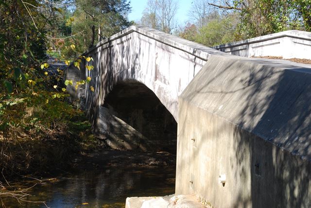
This concrete arch bridge is noted for some unusual design details. First, the road follows the contour of the arch, giving the roadway a humpback look to it. The railing design includes solid parapets with inset rectangles that also follow the arch contour, except that they come to a sharp point at the center of the bridge. On the outside of the bridge, the unusual architectural expression is made where the inset rectangles do not follow the railing, but cover both the railing and arch, hiding any distinction between arch and railing. The bridge appears to retain good historic integrity. The bridge has had a coating applied to it which made reading the marble plaque difficult.
Information and Findings From Pennsylvania's Historic Bridge InventoryDiscussion of Bridge The single span, 41'-long, deck arch bridge built in 1917 has paneled parapets. It is supported on concrete abutments with stone and concrete wingwalls. The sections of stone wingwall appear to date to a previous bridge. The reinforced concrete arch bridge technology was introduced in Pennsylvania about 1900, and by 1910 it had become ubiquitous. It was popular with many county and city engineers. More than 200 examples from before 1916 have been identified with more than 55 from before 1910. This bridge is not an early example in the county or region, and it has no unusual or noteworthy details. It is not historically or technologically distinguished by its setting or context. Discussion of Surrounding Area The 1 lane bridge carries a 2 lane road over a stream in a rural setting with scattered 19th to late 20th century residences. The setting does not have the cohesiveness or integrity of a historic district. Bridge Considered Historic By Survey: No |
![]()
![]()
![]()
Coordinates (Latitude, Longitude):
Search For Additional Bridge Listings:
Bridgehunter.com: View listed bridges within 0.5 miles (0.8 kilometers) of this bridge.
Bridgehunter.com: View listed bridges within 10 miles (16 kilometers) of this bridge.
Additional Maps:
Google Streetview (If Available)
GeoHack (Additional Links and Coordinates)
Apple Maps (Via DuckDuckGo Search)
Apple Maps (Apple devices only)
Android: Open Location In Your Map or GPS App
Flickr Gallery (Find Nearby Photos)
Wikimedia Commons (Find Nearby Photos)
Directions Via Sygic For Android
Directions Via Sygic For iOS and Android Dolphin Browser
USGS National Map (United States Only)
Historical USGS Topo Maps (United States Only)
Historic Aerials (United States Only)
CalTopo Maps (United States Only)

© Copyright 2003-2024, HistoricBridges.org. All Rights Reserved. Disclaimer: HistoricBridges.org is a volunteer group of private citizens. HistoricBridges.org is NOT a government agency, does not represent or work with any governmental agencies, nor is it in any way associated with any government agency or any non-profit organization. While we strive for accuracy in our factual content, HistoricBridges.org offers no guarantee of accuracy. Information is provided "as is" without warranty of any kind, either expressed or implied. Information could include technical inaccuracies or errors of omission. Opinions and commentary are the opinions of the respective HistoricBridges.org member who made them and do not necessarily represent the views of anyone else, including any outside photographers whose images may appear on the page in which the commentary appears. HistoricBridges.org does not bear any responsibility for any consequences resulting from the use of this or any other HistoricBridges.org information. Owners and users of bridges have the responsibility of correctly following all applicable laws, rules, and regulations, regardless of any HistoricBridges.org information.
![]()