

View Information About HSR Ratings
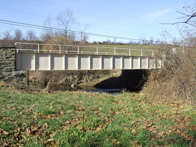
This bridge is a traditionally composed steel through plate girder. The bridge retains excellent historic integrity including county and fabricator plaques. The only noteworthy alteration is the welding of plates onto the floorbeam flanges, which is a minor alteration to say the least. The bridge sits on handsome stone abutments, which add greatly to the aesthetic value of the bridge. The abutments have a third plaque, listing the bridge as rebuilt in 1915, indicating a bridge was at this location prior to the existing bridge's construction.
Chester County is planning to demolish and replace this bridge. However there is a group of local citizens opposed to the replacement of this bridge working to save the bridge. They cite the historic and aesthetic value of the bridge as a reason to preserve the bridge. In addition, they suggest that the existing one-lane bridge is sufficient, given the fact that the bridge carries very little traffic, with a tiny Average Daily Traffic of 134, with a significant portion of this traffic being horse and buggy thanks to a local Amish population. An ADT of 134 is well below the AASHTO Very Low Volume Roadway threshold of 400 ADT, which also suggests that the existing one-lane bridge is functionally sufficient. Further, it is very likely this bridge, which is not in very bad condition, could be rehabilitated for less than the cost of replacing the bridge.
One of the most neglected historic bridge types, both by the Historic Bridge Inventory and the general public as well is the metal riveted plate girder. Plate girders are a structure type no longer built today, nor are rivets used in modern highway construction. While there are a relatively large number of plate girders remaining on Pennsylvania's highways, they are rapidly disappearing as they age and deteriorate and are replaced with new bridges. Nearly all riveted plate girders were written off by the Historic Bridge Inventory as not eligible for the National Register, a finding that PennDOT and the Pennsylvania Historical Museum Commission strongly continue to support.
The Historic Bridge Inventory found the Watermark Road Bridge ineligible for the National Register citing "earlier and more distinguishes examples." Out of approximately 34 examples in Chester County when the survey was conducted, only three plate girders were found eligible. All of these girders were associated with the Pennsylvania Railroad. None of the plate girder bridges that are examples of the county-built water crossings were found eligible.
HistoricBridges.org recognizes the need to not flood historic bridge inventories with eligible findings which have the potential to diminish the value of bridges that are more rare and significant. However, a couple thoughts bear consideration. Just because a particular bridge type is common today, will it always be this common, especially if none are given preservation consideration as historic bridges? Should all examples of a bridge type be written off as "not eligible" just because there are a lot of examples? Instead, HistoricBridges.org suggests that a few examples of this bridge type should be selected for preservation. The Historic Bridge Inventory only found plate girders in Chester County associated with the Pennsylvania Railroad to be historic. Some representation should be given to the county-built water crossing bridges as well. Which bridges among this pool of structures should be selected for preservation? Reasons to select a bridge for preservation should be based on historic significance, feasibility of preservation, and/or community support. In the case of this bridge, while it may not be the oldest or longest example, the bridge does retain excellent historic integrity, appears feasible to preserve, and has the support of the local community. For these reasons, the Watermark Road Bridge should be preserved.
This bridge brings up another problem with how bridges are treated in the United States. Forget whether this bridge is historic or not. Why should it have to take a bridge being "Eligible for the National Register of Historic Places" to get it rehabilitated instead of replaced? The bridge is not in very bad condition, carries very little traffic, rehabilitation would likely cost less than replacement, and the preservation of this bridge has the support of the local community. Regardless of the bridge's historic value, these factors alone suggest that preservation is the prudent choice.
Information and Findings From Pennsylvania's Historic Bridge InventoryDiscussion of Bridge The one span, 54'-long, steel thru girder bridge built in 1915 is an example of a common type and design with no innovative or distinguishing details. The bridge is finished with pipe hand railings. It is supported on stone abutments and wingwalls surmounted by stone parapets. Thru girder bridges have been common as both highway and railroad bridges since the late-19th century. This style of bridge is common in Chester County, and earlier and more distinguished examples have been identified in the county context. The bridge is not significant for its setting, technology, or context. Discussion of Surrounding Area The bridge carries a 2 lane road over a stream in a rural area of active farms. Adjacent to the bridge are pastures. In the distance is a farm with modern horse barn and early 1800s stone farmhouse. The setting does not appear to have historic district potential. Bridge Considered Historic By Survey: No |
![]()
![]()
![]()
Coordinates (Latitude, Longitude):
Search For Additional Bridge Listings:
Bridgehunter.com: View listed bridges within 0.5 miles (0.8 kilometers) of this bridge.
Bridgehunter.com: View listed bridges within 10 miles (16 kilometers) of this bridge.
Additional Maps:
Google Streetview (If Available)
GeoHack (Additional Links and Coordinates)
Apple Maps (Via DuckDuckGo Search)
Apple Maps (Apple devices only)
Android: Open Location In Your Map or GPS App
Flickr Gallery (Find Nearby Photos)
Wikimedia Commons (Find Nearby Photos)
Directions Via Sygic For Android
Directions Via Sygic For iOS and Android Dolphin Browser
USGS National Map (United States Only)
Historical USGS Topo Maps (United States Only)
Historic Aerials (United States Only)
CalTopo Maps (United States Only)

© Copyright 2003-2024, HistoricBridges.org. All Rights Reserved. Disclaimer: HistoricBridges.org is a volunteer group of private citizens. HistoricBridges.org is NOT a government agency, does not represent or work with any governmental agencies, nor is it in any way associated with any government agency or any non-profit organization. While we strive for accuracy in our factual content, HistoricBridges.org offers no guarantee of accuracy. Information is provided "as is" without warranty of any kind, either expressed or implied. Information could include technical inaccuracies or errors of omission. Opinions and commentary are the opinions of the respective HistoricBridges.org member who made them and do not necessarily represent the views of anyone else, including any outside photographers whose images may appear on the page in which the commentary appears. HistoricBridges.org does not bear any responsibility for any consequences resulting from the use of this or any other HistoricBridges.org information. Owners and users of bridges have the responsibility of correctly following all applicable laws, rules, and regulations, regardless of any HistoricBridges.org information.
![]()