

View Information About HSR Ratings
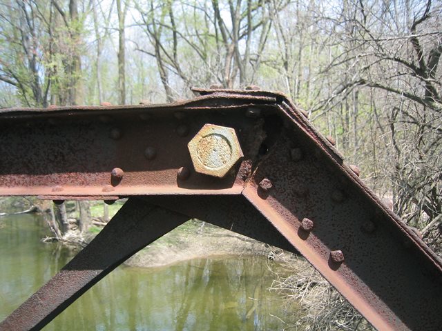
The Michigan Historic Bridge Inventory gives a date of 1910 for the construction of this bridge. However, the bridge has steel brands that read "Jones and Laughlins." The "s" in Laughlins indicates steel dating to before 1905. The 1910 date is likely a "default" date used in some database when the date was unknown. The bridge may be a ca. 1900 bridge, but most likely not date to before 1890, since it displays a standardization that was less common in the 1880s.
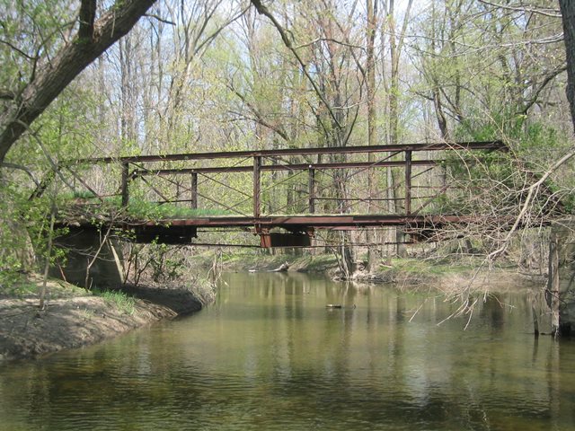
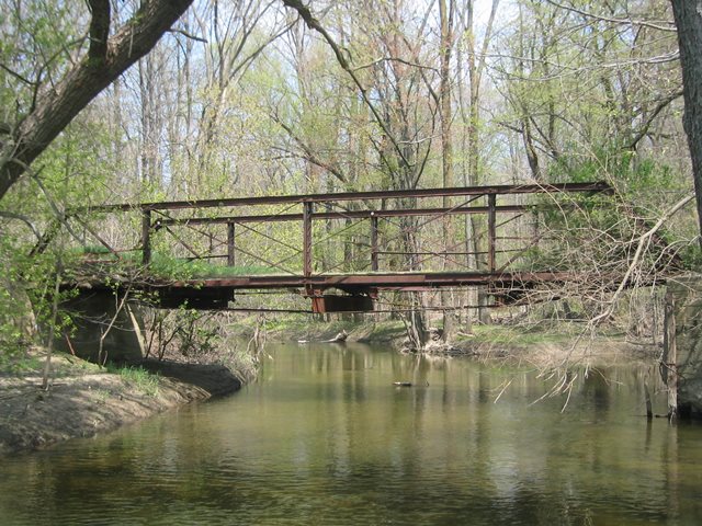
The 27 Mile Bridge is a traditionally designed Pratt pony truss, but is nevertheless very interesting. V-lacing is present on the vertical members of the bridge. The connections are pinned. The bottom chord is nearly completely gone, either from deterioration, or because it was cut off in some areas. However, what remains suggests it was compose of paired channels, which is unusual since eyebars would normally be expected on a pin-connected truss bridge.
The condition of this bridge was very similar to the nearby 28 Mile Bridge, only a bit worse. The 27 Mile Bridge had decayed severely, so bad that some actual parts were missing. Other parts were barely holding together by very small amounts of steel. This bridge appeared to have been retrofitted long ago, with the addition of large i-beams below the original i-beam floor beams below the bridge, combined with an unusual system of rods that run under the whole bridge and act as post-tension rods, today doing nearly all the work of holding the bridge up. Parts of the deck were missing in spots.
By 2014, this bridge had been demolished. Nothing of the bridge except some crumbled pieces of the concrete deck remained along the banks of the river. A photo of the site after bridge demolition is shown below.

Photo Credit: Ken Beaupre
This bridge is tagged with the following special condition(s): Available
![]()
![]()
![]()
![]()
![]()
This historic bridge has been demolished. This map is shown for reference purposes only.
Coordinates (Latitude, Longitude):
Search For Additional Bridge Listings:
Bridgehunter.com: View listed bridges within 0.5 miles (0.8 kilometers) of this bridge.
Bridgehunter.com: View listed bridges within 10 miles (16 kilometers) of this bridge.
Additional Maps:
Google Streetview (If Available)
GeoHack (Additional Links and Coordinates)
Apple Maps (Via DuckDuckGo Search)
Apple Maps (Apple devices only)
Android: Open Location In Your Map or GPS App
Flickr Gallery (Find Nearby Photos)
Wikimedia Commons (Find Nearby Photos)
Directions Via Sygic For Android
Directions Via Sygic For iOS and Android Dolphin Browser
USGS National Map (United States Only)
Historical USGS Topo Maps (United States Only)
Historic Aerials (United States Only)
CalTopo Maps (United States Only)

© Copyright 2003-2024, HistoricBridges.org. All Rights Reserved. Disclaimer: HistoricBridges.org is a volunteer group of private citizens. HistoricBridges.org is NOT a government agency, does not represent or work with any governmental agencies, nor is it in any way associated with any government agency or any non-profit organization. While we strive for accuracy in our factual content, HistoricBridges.org offers no guarantee of accuracy. Information is provided "as is" without warranty of any kind, either expressed or implied. Information could include technical inaccuracies or errors of omission. Opinions and commentary are the opinions of the respective HistoricBridges.org member who made them and do not necessarily represent the views of anyone else, including any outside photographers whose images may appear on the page in which the commentary appears. HistoricBridges.org does not bear any responsibility for any consequences resulting from the use of this or any other HistoricBridges.org information. Owners and users of bridges have the responsibility of correctly following all applicable laws, rules, and regulations, regardless of any HistoricBridges.org information.
![]()