

View Information About HSR Ratings
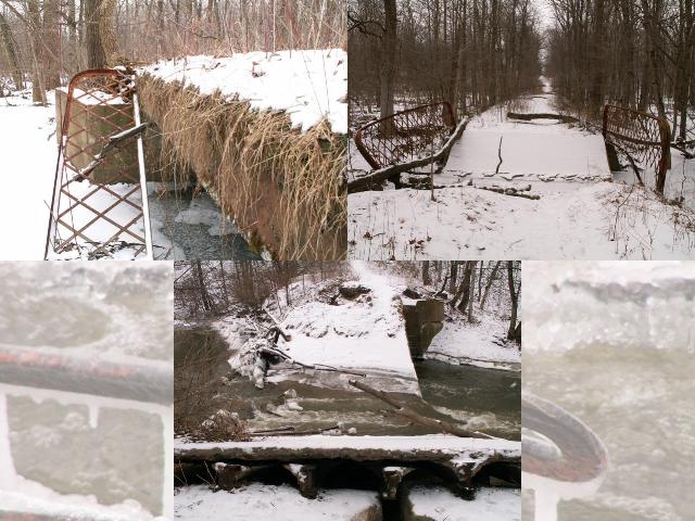
This is a section of abandoned road that can take a person back in time and reveal what a drive in the 1920s might have been like. Three historic bridges used to carry 30 Mile Road over the Clinton River and a couple small branches. Starting from the East, you would cross a small steel stringer beam bridge with lattice guardrails. You would then cross a slightly larger steel stringer beam bridge (which is listed here as the Middle Bridge), which would also have lattice guardrails, but they would be a bit taller. Finally, you would cross the Clinton River, on a pin connected Pratt pony truss. The Michigan Historic Bridge Inventory mentions all three of these bridges, and gives a date of 1920 for the construction of all three bridges. However, in reality, they were likely much older, since the pin-connected truss bridge likely dated to before 1910, and the stringer bridges may have dated to the same time.
Today, the first small beam bridge (from the East) is the only one whose deck still stands. This was a traditional plan steel stringer beam bridge, with standard lattice guardrails and a jack-arch deck. This particular design of bridge appeared to have a guardrail problem, since several of these bridges found in Michigan, including this 30 Mile Road example, have guardrails that are falling off the bridge. It appears to be the way in which the guardrails were held on the bridge via a brace attached to the outside of the bridge... when the brace rusted, the guardrails would fall off. Field stone abutments are present, however these have been completely covered in concrete.
The second, middle bridge, is also a steel stringer beam bridge with lattice guardrails, however the guardrails are taller, and mounted differently. This bridge's fate was exactly the opposite as the first bridge - the deck has collapsed, but the guardrails have survived, mounted into the abutments at each end! The collapse of this bridge appears to have involved the concrete covered field stone abutments. Along with the deck, which appeared to have broken in the middle, the stone abutments are tipping over at one end. Flood waters appear to have helped to wash the abutments free, which resulted in them tipping over.
The truss bridge, which crosses the main Clinton River, appears to have been a pin connected Pratt pony truss. It sat on concrete abutments, that may also have cobblestones behind them. Like the middle beam bridge, the deck appears to have broke in the middle. The abutments seemed intact from what was visible, but the details of what happened might have been hidden from view.
All of these bridges appear to have been collapsed for some time, yet many parts of this bridge remained in the water at this time. Eye bars, turnbuckles, members and even the top chords are still here.
Robert Mahu revisited the bridges in 2010 and found things similar to what they were in 2005 although the lattice railings from the small steel stringer bridge had gone missing. However, by 2011, he visited again and found that the superstructures of all the bridges had been removed. He also found the abutments of a tiny fourth "bridge" that was about 10 yards from the truss bridge. This structure would have been easy to miss and was smaller than the three other bridges.
![]()
![]()
This historic bridge has been demolished. This map is shown for reference purposes only.
Coordinates (Latitude, Longitude):
Search For Additional Bridge Listings:
Bridgehunter.com: View listed bridges within 0.5 miles (0.8 kilometers) of this bridge.
Bridgehunter.com: View listed bridges within 10 miles (16 kilometers) of this bridge.
Additional Maps:
Google Streetview (If Available)
GeoHack (Additional Links and Coordinates)
Apple Maps (Via DuckDuckGo Search)
Apple Maps (Apple devices only)
Android: Open Location In Your Map or GPS App
Flickr Gallery (Find Nearby Photos)
Wikimedia Commons (Find Nearby Photos)
Directions Via Sygic For Android
Directions Via Sygic For iOS and Android Dolphin Browser
USGS National Map (United States Only)
Historical USGS Topo Maps (United States Only)
Historic Aerials (United States Only)
CalTopo Maps (United States Only)

© Copyright 2003-2024, HistoricBridges.org. All Rights Reserved. Disclaimer: HistoricBridges.org is a volunteer group of private citizens. HistoricBridges.org is NOT a government agency, does not represent or work with any governmental agencies, nor is it in any way associated with any government agency or any non-profit organization. While we strive for accuracy in our factual content, HistoricBridges.org offers no guarantee of accuracy. Information is provided "as is" without warranty of any kind, either expressed or implied. Information could include technical inaccuracies or errors of omission. Opinions and commentary are the opinions of the respective HistoricBridges.org member who made them and do not necessarily represent the views of anyone else, including any outside photographers whose images may appear on the page in which the commentary appears. HistoricBridges.org does not bear any responsibility for any consequences resulting from the use of this or any other HistoricBridges.org information. Owners and users of bridges have the responsibility of correctly following all applicable laws, rules, and regulations, regardless of any HistoricBridges.org information.
![]()